A massive and historic winter storm is impacting nearly 245 million Americans and over 40 states The scope of this system continues to be immense, with snow and ice stretching from the Southwest into the Northeast and New England. Significant impacts from very heavy snow to a crippling ice storm are already occurring and will last through the weekend.
A historic major winter storm stretching more than 2,300 miles across the U.S. has begun and is expected to bring over a foot of snow to parts of the Northeast.
The system is delivering harsh winter weather and impacting more than 245 million Americans across 40 states through Monday.
More than 190 million Americans are under Winter Weather Alerts, and 21 states have declared states of emergencies.
The sprawling system began to develop midday Friday in the Plains, bringing heavy snow, ice and rain as it began its journey across the country.
Snow and ice blanketed Texas, Oklahoma and Arkansas, causing power outages throughout the region.

People walk up a hill after sledding in the Hillcrest neighborhood on January 24, 2026 in Little Rock, Arkansas.
(Will Newton/Getty Images / FOX Weather)
On Saturday, the storm moved its way into the Southeast, causing intense ice and snow from Mississippi into parts of the Carolinas.
As of 11 p.m. Saturday night, parts of Virginia, West Virginia and Washington D.C. reported snow beginning to impact the area.
LIVE UPDATES: DANGEROUS WINTER STORM BLASTS THE SOUTH AS POWER OUTAGES SKYROCKET
Significant snowfall and ice accumulation is expected to continue and lead to widespread power outages and major travel disruptions that are expected to last several days.
The FOX Forecast Center is continuing to monitor this massive winter storm. Here is a timeline of how the storm will continue in the following days.
(FOX Weather)
Sunday
CITIES IMPACTED: Nashville, Atlanta, Columbia, Raleigh, Wilmington, Richmond, Washington, Philadelphia, New York City
INTERSTATES IMPACTED: I-81, I-95, I-20, I-40, I-75
AIRPORTS IMPACTED: ATL, BNA, RDU, PHL, DCA, LGA, ROA, JFK, EWR
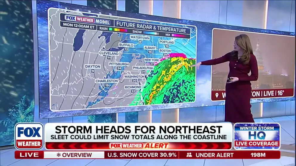
Starting first thing Sunday morning, snow will fall from northern Virginia to potentially as far north as the New York tri-state area. Impacts will continue to be felt in Virginia, D.C. and in the Southeast through Nashville, Atlanta, Columbia, Raleigh, Wilmington and Richmond.
The storm will peak in intensity through the day and into the evening, with snow rates potentially reaching as high as 2 to 3 inches per hour.
Winter Storm Warnings are in place across most of the Northeast, including Washington, DC, New York City, Philadelphia and Boston and will last into Monday. This could be the biggest snowstorm that the I-95 corridor could see in years.

Crews work to clear snow from a sidewalk during a winter storm in Kansas City, Missouri, US, on Saturday, Jan. 24, 2026.
(Clayton Steward/Bloomberg via Getty Images / FOX Weather)
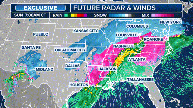
In addition to the snow, strong to severe thunderstorms are possible across parts of the eastern Gulf Coast states into Sunday night.
Louisiana, Mississippi, Alabama, the Florida panhandle and southwest Georgia could see damaging winds of over 60 mph and tornadoes.
Southern portions of Mississippi, Alabama, Georgia and the Florida panhandle are currently under a Level 2 out of 5 tornado threat.

(FOX Weather)
Monday
CITIES IMPACTED: New York, Philadelphia, Washington
INTERSTATES IMPACTED: I-81, I-95, I-80
AIRPORTS IMPACTED: EWR, LGA, JFK, PHL, DCA
With the storm forecast winding down on Monday from west to east, snow and ice will stick around as extremely low temperatures across affected areas will lock in winter weather.
Winter weather will likely persist in the Northeast, including New York City and Philadelphia, as the storm wraps up, with the potential for snow to linger across portions of New England into Monday evening as the area of low pressure pulls away from the coast.
In the South, locations from Dallas to Little Rock could wake up to temperatures in the single digits or even below zero by Monday morning, nearly 30 to 40 degrees below average.

(FOX Weather)
Looking ahead to this week
While current forecasts suggest that the storm will wind down Monday from west to east, the cold weather will stick around for millions of Americans, prolonging impacts for areas affected by ice and snow.
Extreme Cold Warnings and watches now extend across much of the Upper Midwest, Plains and into the Northeast. Major cities included in these alerts range from Minneapolis and Detroit to Boston and New York City.
Temperatures across the Southeast will remain frigid through the early part of next week, leading to prolonged impacts for areas affected by ice and snow.

Video shows ice coating trees and power lines as a winter storm moves through Oxford, Mississippi.
Cities from Atlanta to Raleigh and Wilmington will see temperatures running 15 to 20 degrees below average, with daytime highs struggling to even reach the freezing mark for millions.
Overnight lows are forecast to plunge into the 20s—and potentially the teens—through Tuesday and Wednesday mornings in some areas of the Southeast. This persistent deep freeze will cause any daytime melting to refreeze, creating hazardous black ice and further complicating power restoration and recovery efforts.
Many regions will face the threat of power outages as the frigid temperatures spread over the coming days.


