
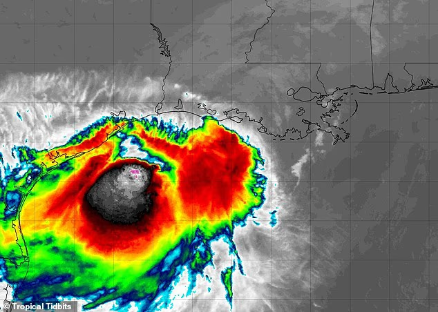
Tropical Storm Bertha is expected to strike the US coast for a second time as forecasters warn that millions of residents could feel the impact within hours.
The heart of the storm has moved back into the Gulf of America after making its first landfall Wednesday afternoon in Alabama and Louisiana.
Meteorologists with AccuWeather said this has allowed Bertha to gather strength as it approaches the Texas coast, near major cities such as Houston, Galveston and Beaumont.
Bertha currently has sustained winds of 45mph and is projected to strike Texas by 3pm ET Thursday at tropical storm strength, bringing potentially dangerous wind gusts of up to 60mph, heavy downpours and flash flooding to coastal communities.
AccuWeather Meteorologist Breanna Grill said in a statement: ‘Flooding rain and storm surge remain the primary threats.’
‘The highest additional rainfall totals of 2-4 inches are expected across a portion of southern and coastal Texas. The Texas Hill Country may be especially susceptible to flash flooding following last week’s catastrophic flooding,’ she added.
Officials in Galveston and Harris Counties have warned residents to prepare for flooding in low-lying areas which may lead to local evacuations when the storm makes landfall.
Authorities in Harris County said: ‘Residents who live in an evacuation zone need to know their evacuation routes and follow instructions from local authorities.’
Tropical Storm Bertha (Pictured) makes its second US landfall in Texas on July 23

Bertha slammed into the Louisiana and Alabama coasts on Wednesday, July 22, causing storm surges and local flooding
AccuWeather Lead Hurricane Expert Alex DaSilva noted that Bertha’s shift into the warm Gulf waters has given the relatively weak tropical storm a chance to reorganize and gain strength instead of dying out over land in Louisiana.
So far, the Gulf has been spared a more severe impact from Bertha thanks to extreme wind shear blowing south from the northern US, which has been slamming into the cyclone and pushing its thunderstorms away from the shore.
DaSilva said in a statement: ‘Even though Bertha will bring its share of problems from flooding downpours, storm surge and gusty winds, people along the central Gulf Coast should feel fortunate in that wind shear likely prevented the storm from becoming a major hurricane.’
Despite the storm’s limitations, over 500 miles of the US Gulf Coast has been under a tropical storm warning over the last 48 hours.
The Florida Panhandle has seen up to three feet of storm surge, where sea levels rise sharply and flood coastal areas.
Forecasters warned that storm surge could reach as high as five feet in some areas as the storm continues to move west and remains at tropical storm strength.
On Wednesday, beaches in Alabama were shut down and swimming was banned under a double red flag warning due to life-threatening rip currents and rough surf.
Vehicles were seen becoming trapped in the sand on the west end of Dauphin Island overnight as waves crashed onto the shore and water levels rose quickly, according to Fox 10.

Bertha has maintained tropical storm strength after moving back into the Gulf of America

Cars in Alabama were seen submerged as Tropical Storm Bertha caused storm surges of several feet as it made landfall on July 22
Thousands of Louisiana residents lost power on Wednesday as Bertha made its first landfall before 3pm ET.
Over 1,200 customers in Uptown New Orleans were without power Wednesday night as the storm barreled over Orleans and Jefferson Parishes, according to 4 WWL.
As of 10am ET on Thursday, nearly 500 customers in the area were still without power.
In Texas, officials with Galveston’s emergency management department have urged residents to secure that outdoor furniture and other loose objects that could be swept away by Bertha’s strong winds and become deadly projectiles.
Despite the warnings, officials in Texas stated that they believed Tropical Storm Bertha would quickly dissipate once it hits the coast.
According to both the National Hurricane Center and AccuWeather, there are also no signs of another Atlantic storm developing during the final week of July.
Bertha is the first named storm to make landfall in the US since Tropical Storm Chantal in July 2025. The last named storm to strike Louisiana was Hurricane Francine in 2024.

Residents along the Gulf Coast have been urged to avoid coastal areas and prepare for potential flood evacuation orders
The Atlantic hurricane season has been extremely quite to this point, with Bertha only being the second named storm since the tropical cyclone window opened in June 1.
The lack of activity between the African coast and the Caribbean has been credited to the emergence of a ‘super’ El Niño in the Pacific Ocean.
An El Niño is a natural climate pattern in which the central and eastern Pacific surface temperature becomes significantly warmer than average, flipping weather patterns worldwide.
This has the effect of calming typically unsettled conditions in the Atlantic, and producing fewer severe storms during hurricane season.
On July 7, AccuWeather officially lowered its prediction for hurricane season because of the impact of El Niño this year.
The weather agency now believes there will be between eight and 14 named storms in the Atlantic this year, down from their prediction of 11 to 16 in March.


