
Over the summer, devastating wildfires have swept across Europe, displacing thousands of people.
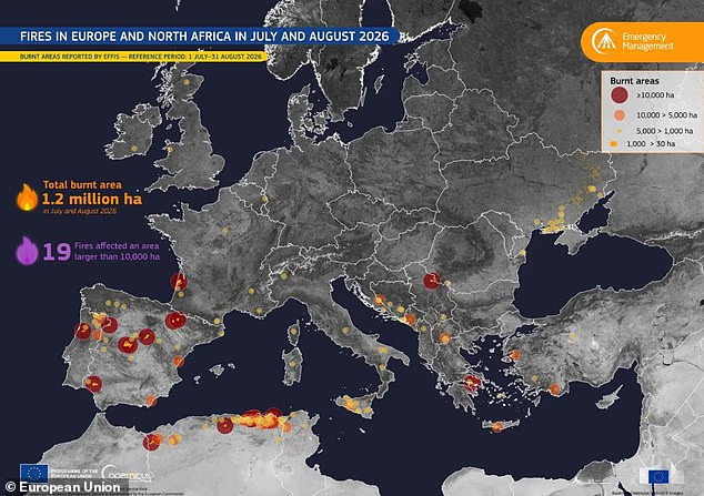
Now, the true extent of the damage has been revealed in a new map released by the European Union.
The map uses data from the European Forest Fire Information System, and shows the areas where fires larger than 30 hectares burned between 1 July and 31 August.
It reveals how, in total, more than 1.2 million hectares of land burned during those two months alone.
‘Fires affected large areas of Europe and North Africa during the summer of 2026, with extensive burnt areas across the Iberian Peninsula, southern France, Italy, Greece, the Balkans, Ukraine, and Algeria,’ the EU explained.
Looking ahead, things are set to get even worse.
A recent study warned that the area ravaged by wildfires in Europe is set to almost triple by 2100.
Co–author Dr Kirsten Thonicke, of the Potsdam Institute for Climate Impact Research, said: ‘With climate change, conditions could become so extreme that we really hit limits to what we can do to prevent and fight fires once they get to a certain size.’
Over the summer, devastating wildfires have swept across Europe, displacing thousands of people. Now, the true extent of the damage has been revealed in a new map released by the European Union
On the new map, you’ll see shapes of various sizes and colours.
Nineteen are large, red circles, which indicate fires exceeding 10,000 hectares.
Orange circles depict fires reaching between 5,000 and 10,000 hectares, while small yellow circles show areas where 1,000 to 5,000 hectares burned.
Finally, orange polygons show smaller burnt areas.
Scientists warn that a hotter, drier climate will make these kinds of fires more common and widespread in the future.
In a ‘high emissions scenario’, where countries don’t take steps to cut pollution, temperatures could soar 3.6°C (6.5°F) above the pre–industrial average.
Using computer modelling, the Potsdam researchers predict this will increase the area of Europe affected by wildfires by 193 per cent, reaching 20,463 square miles (53,000 square km) per year.
That increase would be spread across much of western and Central Europe as well as the Mediterranean, where a record–breaking fire season has already been raging.

Looking ahead, things are set to get even worse. A recent study warned that the area ravaged by wildfires in Europe is set to almost triple by 2100

This summer, Europe faced one of the worst fire seasons on record. Pictured: Firefighters battle a blaze in Galicia, Spain
However, the researchers also predict that human–caused climate change would see fires igniting in parts of Europe previously unaffected by large blazes.
The team did find that good preparation could substantially cut down on the potential damage.
Continued improvements in fire management have the potential to reduce burned area by 92 per cent in a 1.8°C future and 72 per cent at 3.6°C.
However, they also caution that these predictions could prove overly optimistic in the worst–case scenario.
Co-author Professor Thomas Hickler, of the Senckenberg Society for Nature Research adds: ‘If Europe increases investment in wildfire management, our projections show that this can make a significant difference.
‘But if fires become really extreme, our ability to contain them might break down, and we do not know yet where this point is.’




