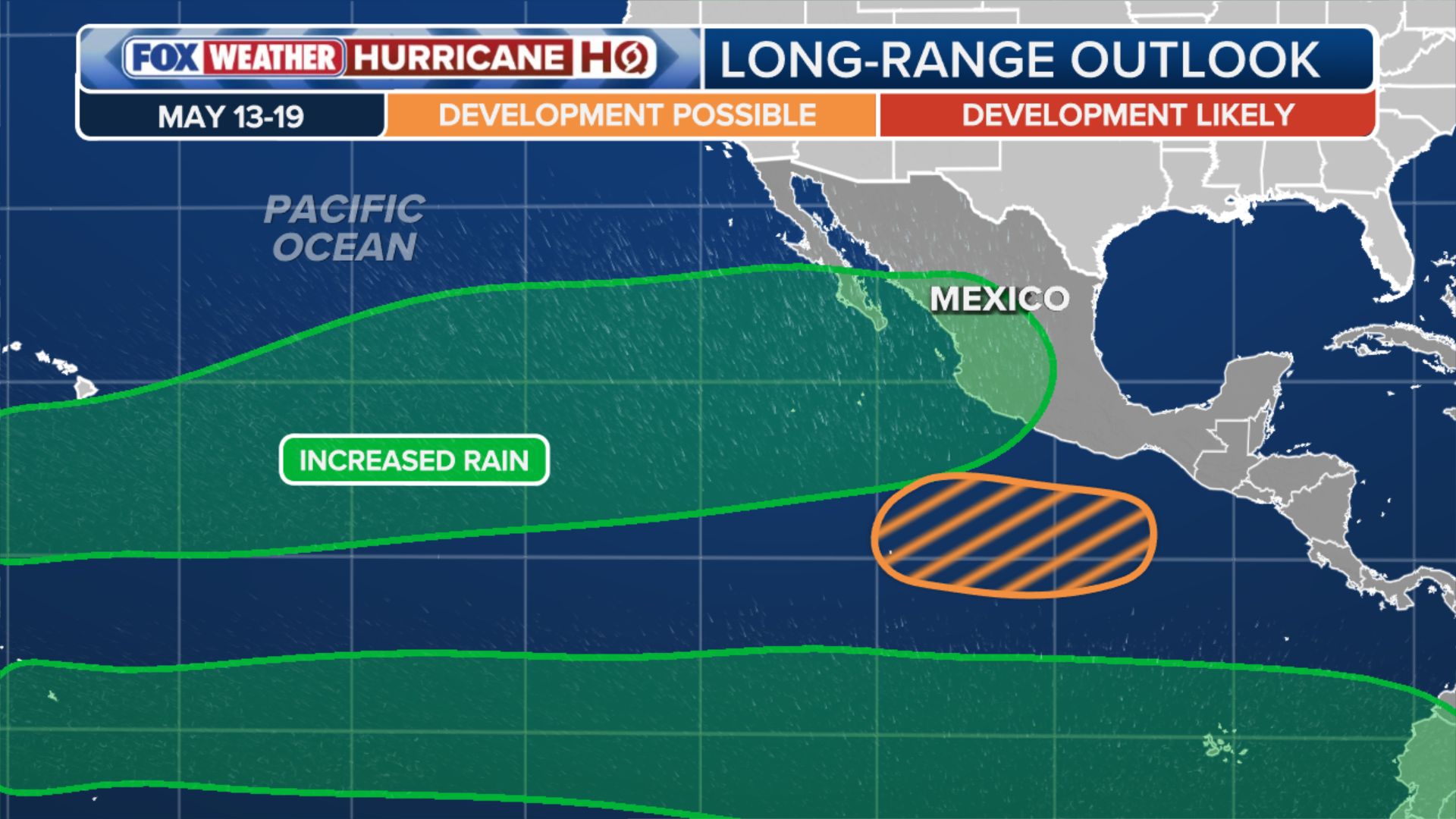
NOAA’s Climate Prediction Center (CPC) has highlighted an area off the southern coast of Mexico for potential tropical development, with a little more than two weeks before the start of hurricane season in the Eastern Pacific. This comes with the El Niño climate pattern forecast to develop sometime this summer, which is expected to increase the number of named storms in the basin.
NOAA‘s Climate Prediction Center (CPC) has highlighted an area off the southern coast of Mexico for potential tropical development, with a little more than two weeks before the start of hurricane season in the Eastern Pacific.
This comes with the El Niño climate pattern forecast to develop sometime this summer, which is expected to increase the number of named storms in the basin.
EXCLUSIVE ANALYSIS: EL NIÑO LIKELY TO BOOST HURRICANE ACTIVITY IN EASTERN PACIFIC THIS SUMMER
(FOX Weather)
The CPC said a tropical system could develop off the coast of Mexico between May 13 and May 19.
PACIFIC OCEAN GETTING WARMER AS HURRICANE SEASON NEARS AND EL NIÑO BECOMES MORE LIKELY
According to the FOX Forecast Center, sea surface temperatures are running slightly above average, with some localized regions reaching the upper 80s.
These conditions are already roughly 2 to 3 degrees above average and more than sufficient to support tropical development — typically tropical cyclones form over waters that are above 80 degrees.
(FOX Weather)
While this timing isn’t unusual — the first named storm generally forms in the Eastern Pacific around June 10 — the combination of waters already above average and a developing El Niño suggests that this could be the start of a supercharged hurricane season in the basin.
TYPHOON SINLAKU MAKES DIRECT HIT ON US TERRITORIES IN PACIFIC, BLASTING SAIPAN WITH 130 MPH WINDS
In fact, warm water temperatures in the Pacific greatly enhanced Super Typhoon Sinlaku earlier this month. Sinlaku slammed into the U.S. territory of the Northern Mariana Islands in the Western Pacific with wind speeds approaching 200 mph.
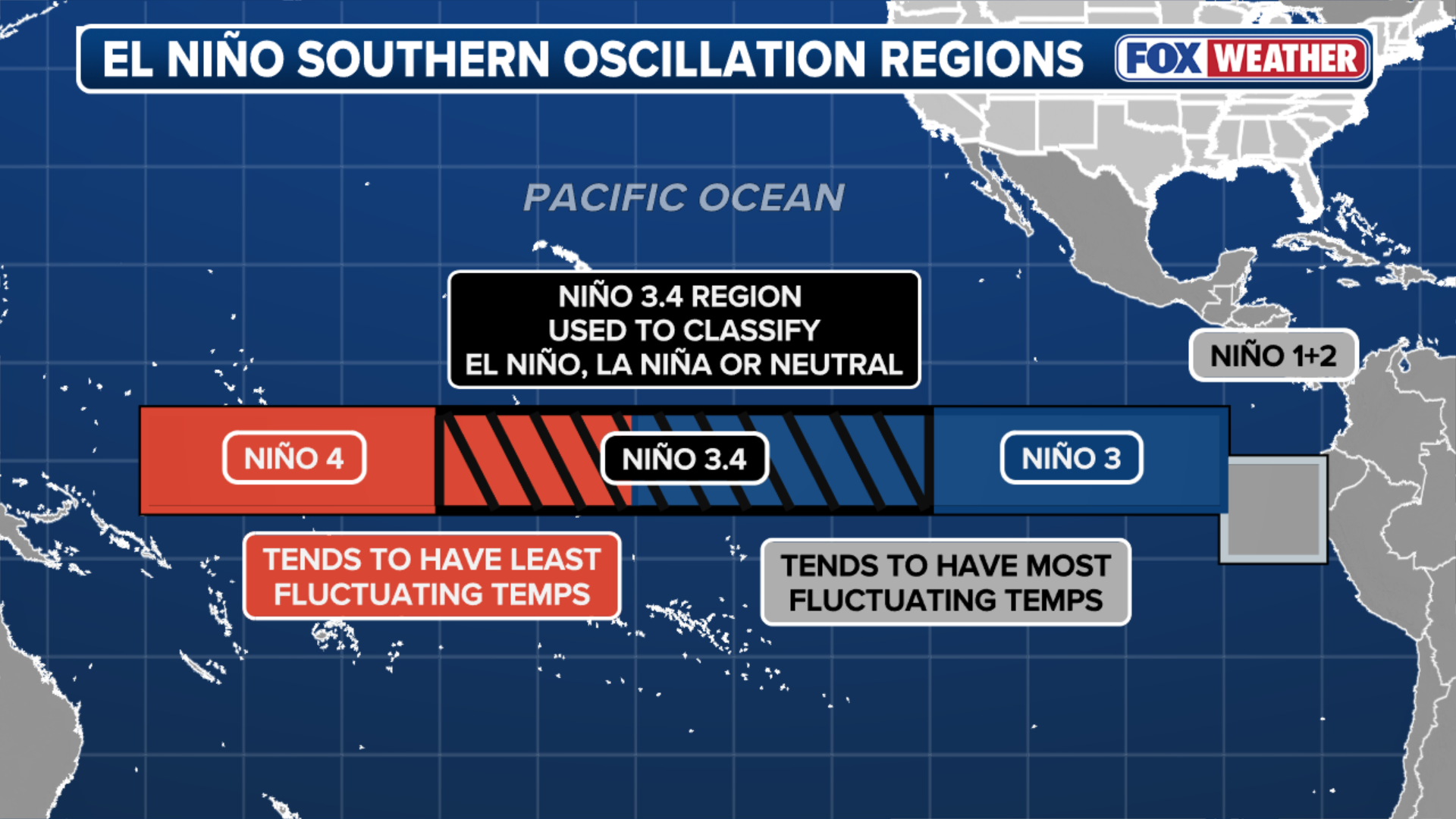
El Niño is one of three phases of a climate cycle called the El Niño-Southern Oscillation (ENSO). It describes natural temperature changes in the central Pacific Ocean that alter atmospheric circulation and can greatly influence global weather.
WHAT ARE EL NINO AND LA NINA CLIMATE PATTERNS?
El Niño describes warmer than average water across the equatorial Pacific, while La Niña describes colder than average water conditions, and ENSO neutral refers to a state where temperatures are close to average.

El Niño impact on hurricane season.
(FOX Weather / FOX Weather)
According to the FOX Forecast Center, while El Niño generally suppresses tropical activity in the Atlantic Basin, the warmer sea surface temperatures provide more fuel for tropical storms and hurricanes to develop in the Pacific.
THE COST OF DISASTER: HOW TO PROTECT YOUR HOME AHEAD OF HURRICANE SEASON
In addition, El Niño also generally encourages warm air to rise rapidly in the Eastern Pacific, which creates the clouds and thunderstorms necessary to seed a hurricane or other tropical cyclone.
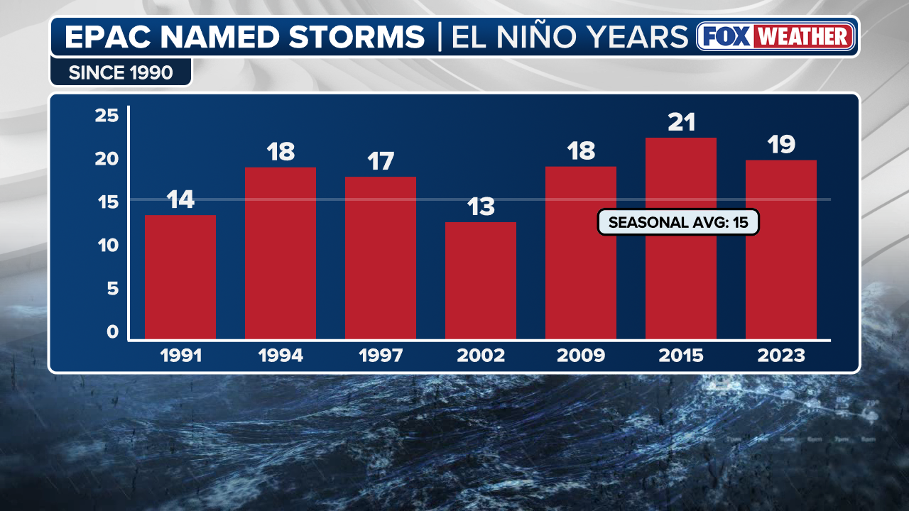
On average, the Eastern Pacific basin sees 15 named storms, 8 hurricanes, and 4 major hurricanes (Category 3+). Those averages were significantly higher during El Niño years, which produced: 17 named storms, 9 hurricanes, and 5 major hurricanes.
(FOX Weather)
The Forecast Center noted that while the exact timing of when El Niño develops is important, even moderate El Niño years have above-average tropical activity.
In fact, experts believe this El Niño could significantly outpace the average event. Computer models from both NOAA and Columbia’s International Research Institute (IRI) suggest a super El Niño may be on the horizon — which could serve to further supercharge storm activity across the Eastern Pacific.
Eastern Pacific hurricane season begins on May 15 and runs through Nov. 30.


