Heavy rain and severe storms are expected to reignite across the Gulf Coast and the Southeast with the potential for damaging winds and large hail. FOX Weather Meteorologists Stephen Morgan and Britta Merwin break down the latest threat zone:
Millions of Americans are bracing for a wave of stagnant weather this week with the potential for soaring temperatures and severe storms across the country.
An Omega block weather pattern is starting to take hold across the U.S., leaving various regions under the same conditions all week long.
Omega block weather patterns get their name because the upper air pattern looks like the Greek letter omega (Ω).
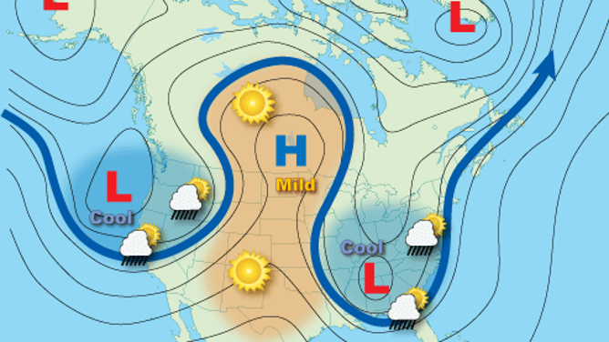
According to the National Oceanic and Atmospheric Administration (NOAA), an Omega block is a combination of two cutoff lows, with a blocking high sandwiched between them.
An example of an Omega block weather pattern and its affects across the country.
(National Oceanic and Atmospheric Administration (NOAA))
This weather pattern occurs when a large ridge of high pressure (the hump) is sandwiched between two troughs of low pressure on both sides.
HOW HIGH PRESSURE AND LOW PRESSURE DRIVE THE WEATHER
This setup creates a type of atmospheric traffic jam because weather systems normally zip across the country from west to east.
Still, this system often becomes stuck over regions for days, leading to prolonged periods of the same weather.
⛈️ MASSIVE HAIL: Hail came splashing down into the pool outside of a residence in Scurry County, Texas, where locals are under a severe thunderstorm watch for the rest of the day.
This could entail heat, rain, fog, cloudy skies and much more.
It is worth noting that this Omega block is lacking in the “blocking” category, but it will be better determined by Wednesday, according to the FOX Forecast Center.
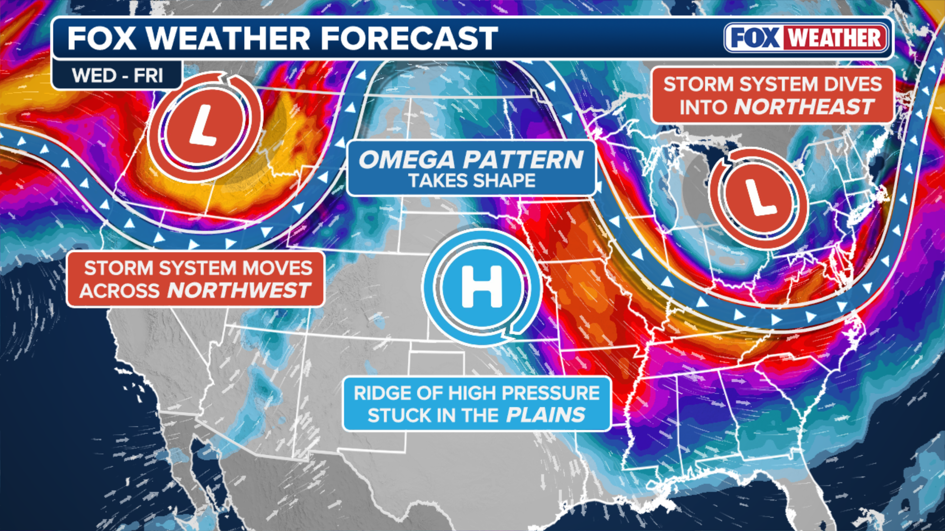
(FOX Weather)
West Coast effect
Forecasters predict that, given the current weather pattern, a surge of southerly winds could reach the Northwest U.S., potentially bringing record heat and rain.
The left side of the Omega block, a low-pressure system, will hover over the Pacific Northwest, where rounds of light to moderate rain will drench the region until the end of the work week.
TRIPLE-DIGIT HEAT RETURNS TO THE WEST AS DOZENS OF MAJOR CITIES EYE RECORD-BREAKING TEMPERATURES
“These storms will be more of an annoyance than a major event,” the FOX Forecast Center said. “Expect repetitive rounds of light to moderate rain.”
Central US effect
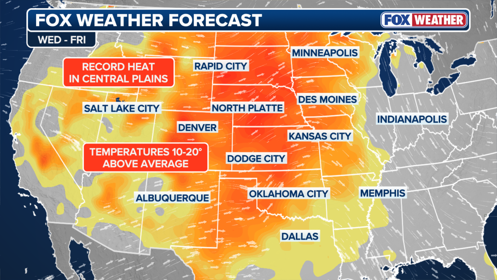
The center of the Omega block features a massive ridge (the hump) of high pressure, which is responsible for the upcoming surge in heat across states in the Central U.S.
(FOX Weather)
As the ridge continues towards the center and heat shifts from the west to the Central U.S., the warm air will halt and sink over the region, leading to clear skies and temperatures soaring 15 to 25 degrees above average, according to the FOX Forecast Center.
East Coast and Midwestern effect
The opposite will occur on the right side of the Omega, where the Northeast and Mid-Atlantic regions will experience a round of severe storms that could bring damaging hail and winds.
Popular cities that could be affected by severe weather include Chicago, Milwaukee and Kansas City.

A woman walks with difficulty in the heavy rain as a winter storm brings snow and gusty winds, creating challenging travel conditions on roads and at airports in Chicago, United States, on March 15, 2026. Nearly 500 flights at Chicago’s O’Hare Airport are canceled and hundreds more delayed as the storm disrupts travel nationwide.
(Jerome Gilles/NurPhoto / Getty Images)
Once this severe threat passes, the “stuck” nature of the Omega block pattern will keep dark clouds and scattered showers in the forecast through Friday for the Northeast, while the Midwest and the rest of the Southern U.S. will enjoy spring warmth to end the week.
Overall, much of the U.S. will experience days of stagnant weather due to the Omega block, which will taper off a bit, but conditions will linger after the worst of it throughout the week.


