As many as 40 million people across eight states are in the deadly path of Tropical Storm Arthur after the first named storm of hurricane season made landfall Wednesday night.
Arthur, which has been downgraded to a post-tropical cyclone on Thursday, slammed into the Texas Coast last night, and is now projected to barrel across the South, bringing severe flooding from Louisiana to the Carolinas.
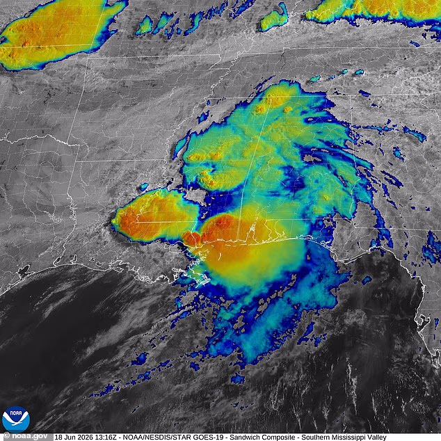
Meteorologists with AccuWeather warned that Louisiana, Mississippi, Alabama and the Florida Panhandle will see ‘extreme’ levels of flooding along the coast and in urban areas throughout Thursday, with as much as 12 inches of rain falling.
Georgia and the Carolinas are expected to be impacted on Friday, as forecasters say Arthur will continue to bring ‘life-threatening flooding, property damage and disruptions to commerce and travel.’
AccuWeather Hurricane Expert Alex DaSilva warned in a statement: ‘Rainfall rates can reach 2-4 inches per hour, which can cause flooding to occur quickly and result in road closures, especially in urban areas.’
However, flooding is not the only concern tied to Arthur, as the National Weather Service has also issued a widespread tornado watch across coastal areas in Louisiana, Mississippi, Alabama and the Florida Panhandle.
In Mississippi specifically, weather officials upgraded that alert to an official tornado warning in Perry, Greene, Stone, Harrison, Hancock and Pearl River Counties – warning that twisters could touch down at any moment.
NWS said in a statement: ‘TAKE COVER NOW! Move to a basement or an interior room on the lowest floor of a sturdy building. Avoid windows. If you are outdoors, in a mobile home, or in a vehicle, move to the closest substantial shelter and protect yourself from flying debris.’
Tropical Storm Arthur made landfall on Wednesday, June 17 in Texas and has moved over the Gulf states on Thursday

Flooding in Texas and Louisiana has already been reported
Tropical Storm Arthur’s June 17 landfall is the earliest a named storm has hit the US mainland since Tropical Storm Cristobal struck Louisiana on June 7, 2020.
It has been 40 years since a hurricane made a June landfall in the US, when Bonnie landed in Texas in 1986.
Only one tropical storm made a direct hit on the US last year, when Tropical Storm Chantal struck South Carolina on July 6, 2025.
Although the weather phenomenon known as El Niño is expected to make this Atlantic hurricane season weaker than normal, forecasters have warned that conditions could particularly extreme between Texas and the Carolinas all summer.
While El Niño flips global weather patterns, making it warmer in the Pacific and cooler in the Atlantic, it also pushes the natural jet stream flowing over the US farther south, creating a continuous stream of turbulent air over the southern half of the country.
AccuWeather’s Paul Pastelok told the Daily Mail that the 800-mile-long corridor between Houston, Texas and Atlanta, Georgia is likely to see continuous extreme weather events, even if they do not become tropical storms and hurricanes.
‘As far as heavy rainfall and tornadoes, Houston to Atlanta, Orlando and parts of the Mid-Atlantic, pick a city… those are more concerning, especially as you get into later this year,’ Pastelok warned.
Arthur’s path on Thursday and Friday will follow that exact route, according to the latest tracking models, likely exiting in the Atlantic after surging through North Carolina on Saturday.
This is a breaking story. More details to follow.

Spaghetti models show the remnants of Arthur moving east from Thursday into Friday

The impact of Arthur is projected to be ‘extreme’ in Louisiana, Mississippi and Alabama
Texas Governor Greg Abbott issued a disaster declaration for 101 Texas counties due to the severe storms, heavy rainfall and flooding cause by Arthur this week.


