Millions have been warned to brace for a potential ‘Ring of Fire’ weather pattern as a powerful heat dome develops across parts of the US.
Meteorologists said the storm corridor will begin taking shape as early as Monday, developing along the northern edge of the expanding dome of high pressure before shifting east through the week.
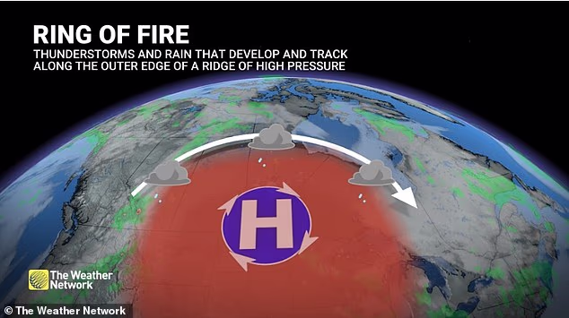
AccuWeather’s senior meteorologist Chad Merril’ told the Daily Mail: ‘Ring of Fire refers to the arc of instability along the periphery of the high pressure in which you have the best opportunity for thunderstorm development.’
The greatest risk is expected to target Detroit, Philadelphia, Washington DC, Richmond, Virginia and New York City, where residents could face clusters of severe thunderstorms capable of producing damaging winds.
Merrill said the threat will then migrate from the Upper Midwest into the Great Lakes before reaching the Northeast and Mid-Atlantic by Thursday.
The volatile storm pattern will unfold while millions endure dangerous heat and humidity beneath the growing heat dome, creating a combination of oppressive temperatures and explosive weather.
The heat dome is expected to begin developing on Sunday before strengthening through early next week and expanding northward into the Midwest.
‘Typically, under these heat domes, there’s little in the way of air circulation,’ Merrill said. ‘What you tend to see is the potential for air quality alerts to develop, especially in urban areas, so we could see some poor air quality develop next week.’
The greatest risk is expected to target Detroit, Philadelphia, Washington DC , Richmond, Virginia and New York City , where residents could face clusters of severe thunderstorms capable of producing damaging winds
People living in affected areas are being urged to stay weather aware, limit strenuous outdoor activity during the hottest parts of the day and prepare for rapidly changing conditions.
The phenomenon, known as the ‘Ring of Fire,’ develops along the northern edge of a heat dome where cooler air collides with intense heat, creating the ideal environment for powerful thunderstorm complexes.
The meteorologist explained that the Ring of Fire is not a single storm but rather an arc of atmospheric instability that forms around the outer edge of a strong high-pressure system.
As temperatures soar beneath the center of the heat dome, cooler air to the north creates a sharp temperature contrast.
Small disturbances moving along the jet stream interact with that unstable air mass, allowing clusters of thunderstorms to rapidly organize and race across the northern edge of the ridge.
As it grows larger on Monday, forecasters expect the first thunderstorm clusters to develop across Minnesota and Wisconsin.
Those storms are then forecast to shift eastward into the Great Lakes before reaching the Interstate 95 corridor later in the week.
‘At this rate, those cities would have the best opportunity,’ Merrill said.

The phenomenon, known as the ‘Ring of Fire,’ develops along the northern edge of a heat dome where cooler air collides with intense heat, creating the ideal environment for powerful thunderstorm complexes (STOCK)
‘Once you get closer to an event like this, you can kind of hone in a bit on specifics, but this far out, it’s difficult to pinpoint exactly.’
By the Fourth of July holiday, the center of the heat dome is expected to settle over the south-central Plains, although dangerous heat will likely persist across much of the central and eastern US.
The heat itself may prove just as hazardous as the storms.
Merrill warned that prolonged periods of hot, humid weather beneath a heat dome often produce little air circulation, allowing pollutants to accumulate over large cities.
As a result, urban areas including Nashville, Indianapolis, Cincinnati and possibly Chicago could experience deteriorating air quality during the heat wave.
Poor air quality can pose a serious risk to people with asthma, chronic lung disease and other respiratory conditions.
Merrill also warned that homes without air conditioning can remain dangerously hot even after sunset.
While many cities open cooling centers during extreme heat, those facilities often close in the evening, forcing people to return to homes that may still be heating up between 8pm and 10pm.
‘There is a risk for people who go to the cooling centers and then go back home to suffer from some sort of heat-related illness even in the evening,’ Merrill said.
Extended periods of intense heat can also increase electricity demand as millions run air conditioners simultaneously.
If temperatures climb into the upper 90s or low 100s for several consecutive days, isolated power outages or flickering electricity become more likely due to increased strain on the electrical grid.
Health officials recommend drinking plenty of water, wearing loose-fitting clothing, limiting outdoor exercise to the early morning or late evening, checking on elderly neighbors and ensuring pets are not walked on scorching pavement during the hottest part of the day.
Signs of heat exhaustion include dizziness, excessive sweating, a sudden lack of sweating and chills while outdoors. Anyone experiencing those symptoms should move to a cooler location immediately and seek medical attention if symptoms worsen.
Meteorologists are also closely monitoring the developing setup as a large ridge of high pressure begins to strengthen across the southern US.
Areas positioned along that edge, including parts of northern Louisiana, face the greatest risk of storm activity as clusters of thunderstorms ride around the perimeter of the high-pressure system.
Highs in the Northeast and Mid-Atlantic could climb into the upper 80s and mid-90s, while overnight lows may remain in the mid-60s to mid-70s, offering little relief from the heat.
Meteorologists warn the warmer-than-normal conditions could persist through the Fourth of July holiday.


