Last month was the second–hottest May on record, the Copernicus Climate Change Service (C3S) has revealed.
The average global temperature was a balmy 15.81°C in May, which is 0.55°C above the 1991–2020 average.
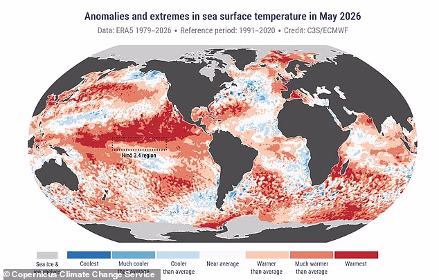
What’s more, at 20.90°C, sea surface temperatures were the second highest on record for the month.
This suggests a Super El Niño could be on its way in the ‘coming months’, according to the experts.
If it does arrive, the Super El Niño will bring extreme heat ‘nearly everywhere’, with the potential for global average temperatures to rise by as much as 3°C (5.4°F) this summer.
In addition, the rare climate event could wreak havoc on rainfall patterns around the world.
Samantha Burgess, Strategic Lead for Climate at European Centre for Medium–Range Weather Forecasts (ECMWF), said: ‘May 2026 was the second warmest May on record globally, extending the exceptional global warmth, with near–record temperatures in both the atmosphere and the ocean.
‘In Europe, an unusually early and intense heatwave demonstrates how quickly climate extremes are becoming the new normal rather than the exception.’
Last month was the second–hottest May on record, the Copernicus Climate Change Service (C3S) has revealed
Across Europe, May saw a rapid transition from much cooler–than–average conditions to one of the most intense heatwaves ever observed this early in the year.
During the second half of the month, temperature records were broken across the UK, France, Ireland and Portugal.
In addition, there were contrasting dry and wet conditions across Europe.
Large parts of western, central and eastern Europe experienced drier-than-average conditions through the month.
Conversely, there was flooding in Turkey, Bulgaria and Moldova, as parts of northwest continental Europe, north Scandinavia, Finland, Türkiye and the Black Sea region were wetter than average.
However, the biggest cause for concerns is the sea surface temperature (SST), which was just 0.03°C lower than the 2024 record of 20.93°C.
‘SSTs remained at exceptionally high levels across a large portion of the tropical Pacific as the equatorial Pacific continues its transition towards El Niño conditions, expected to develop in the coming months,’ Copernicus warned.
The El Niño–Southern Oscillation is a natural climate pattern which cycles between a hot El Niño and a cool La Niña phase every two to seven years.

The average global temperature was a balmy 15.81°C in May, which is 0.55°C above the 1991–2020 average
During the El Niño part of the cycle, warm waters that build up in the Pacific spread out and raise the Earth’s average surface temperature.
This heat ends up escaping into the atmosphere, raising our planet’s temperature for months.
While the El Niño–Southern Oscillation has been going on for hundreds of thousands of years, current signs point to this year being one of the strongest El Niño patterns ever recorded.
According to the World Meteorological Organisation (WMO), we can expect above-normal temperatures in ‘nearly all parts of the globe’.
As it stands, scientists from the WMO say there’s an 80 per cent likelihood of an El Niño event during June–August 2026, and a 90 per cent chance this will continue until at least November.
‘The science is clear: El Niño is arriving on our doorstep in the coming months with 90% certainty,’ said UN Secretary–General António Guterres.
WMO Secretary–General Celeste Saulo added: ‘We need to prepare for a potentially strong El Niño event – which will exacerbate drought and heavy rainfall and increase the risk of heatwaves both on land and in the ocean.
‘The most recent El Niño, in 2023–24, was one of the five strongest on record and it played a role in the record global temperatures we saw in 2024.
‘The WMO community will be carefully monitoring conditions in the coming months to inform decision–making by governments, humanitarian agencies and climate–sensitive sectors.
‘Advance seasonal forecasts and early warnings are vital to save lives and cushion the impact on our economies and our communities.’


