Storm delivers heavy rain and strong wind gusts to Manhattan on Monday afternoon. (Video: @Lindz_Marie85/Twitter)
After a stormy start to the week for much of the East, a few dry days will be dampened by another round of rain, isolated flash flooding heading into the end of the workweek and the start of the weekend.
HOW HIGH PRESSURE AND LOW PRESSURE DRIVE THE WEATHER
An area of low pressure impacting the Plains will begin moving east into the Great Lakes on Thursday evening, and by Friday morning before tracking through the Northeast with a trailing cold front extending from New York through the Ohio Valley and Midwest.
This front will serve as the focus for showers and downpours Friday afternoon.
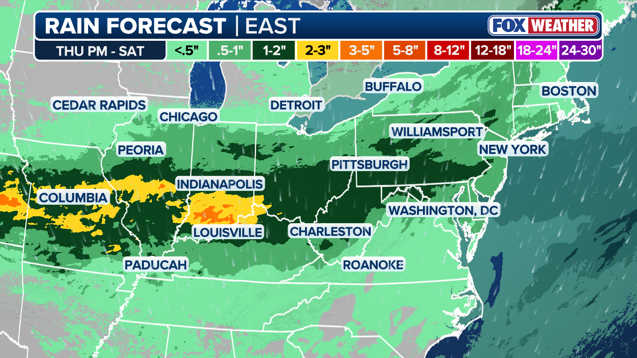
With soils already saturated, and heavy rainfall rates expected, a Level 2 of 4 flash flood risk is in effect across parts of the Ohio Valley on both Friday and Saturday. The threat includes major cities such as St. Louis, Indianapolis, Cincinnati and Louisville.
SAHARAN DUST SETTLES OVER HURRICANE BREEDING GROUNDS. HERE’S WHAT IT MEANS FOR HURRICANE SEASON
On Saturday, the area of low pressure will continue east and be positioned near far eastern Maine. As the trailing cold front slows, instability will increase ahead of it while moisture surges northward from the Gulf and Atlantic Ocean.

FILE: Rain falls in New York City on March 23, 2024.
(FOX Weather)
Showers and downpours are expected to develop across the Mid-Atlantic and Northeast, including areas from Cincinnati, Ohio, to Washington, D.C., and New York City, during the afternoon.
KNOW YOUR FLOOD TERMINOLOGY: WHAT FLOOD WATCHES, WARNINGS AND EMERGENCIES REALLY MEAN
Let’s take a look at how trading on prediction markets has varied for how much rain New York City will see by the end of June.
By early Sunday, widespread rainfall totals of 1 to 2 inches are possible from southern Indiana through West Virginia, Pennsylvania and New Jersey. Localized amounts exceeding 2 to 3 inches could occur where slower-moving or training thunderstorms develop.
Some lingering showers are possible Sunday across parts of the Northeast with leftover instability in the atmosphere before drier and more seasonable weather is expected to return by Monday.


