We had a taste of the heat and humidity Wednesday along with a dose of afternoon thunderstorms, but we’re in for hotter temperatures, more humidity and the threat for more storms for Thursday and Friday.
The DC News Now Weather Team has issued a DMV First Warn Day for Friday for the threat of strong to severe storms as a cold front tries to push out the high heat and humidity that has settled over the region.
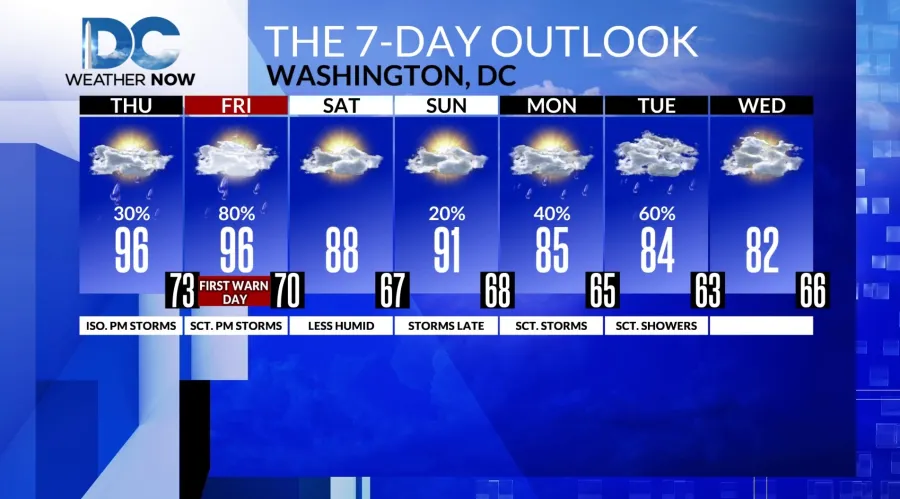
Before we get to Friday’s storm threat, let’s get you through Thursday. There is still a storm threat Thursday, but these will likely be bubbling up later in the day, closer to the evening commute. So, not only do you want to stay weather-aware for the threat of storms, you’ll also want to stay cool and hydrated. With highs reaching into the mid-90s, and with dewpoints into the 70s, the heat index is expected to reach into the triple digits for several hours Thursday afternoon and Friday afternoon.
Friday, highs will also reach into the mid to upper 90s, dewpoints into the 70s before the cold front dives in from the northwest. Storms could contain heavy downpours, strong wind gusts and the possibility of hail.
Behind the cold front, dewpoints will drop into the upper 50s for Saturday, which is much more comfortable. Highs Saturday will be in the upper 80s under a mix of sun and clouds. Sunday will start to bring back some humidity, and we’ll see increasing clouds ahead of yet another front that will bring storm chances late Sunday. Storm chances linger into Monday, but highs will dip back into the mid-80s. Tuesday and Wednesday slide into the lower 80s for highs.


