California‘s towering redwood trees have long stood atop a hidden earthquake threat that could unleash widespread devastation if it awakens.
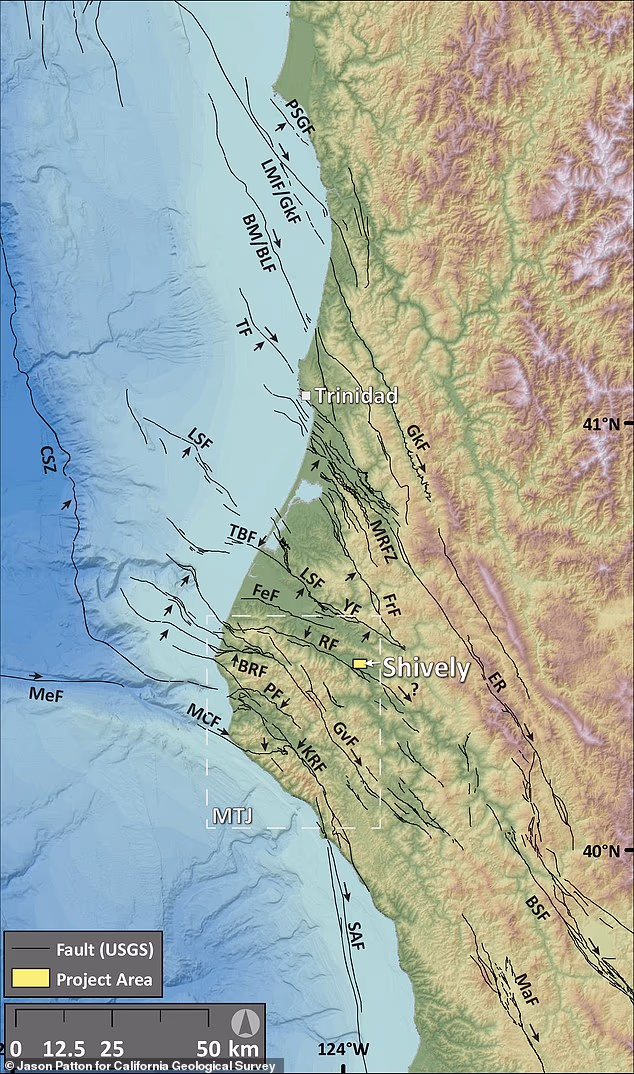
Geologists have confirmed a previously unmapped active fault in Humboldt County after uncovering evidence that it produced at least four major earthquakes over the past 20,000 years.
The Shively Fault lies near the small community of Shively within the Mendocino Triple Junction, where three tectonic plates collide, making it California’s most seismically active region.
Researchers say the fault could be capable of producing a magnitude 7 or greater earthquake if their mapping confirms it extends beyond the currently identified section.
An earthquake of that magnitude could produce widespread, damaging shaking across parts of Northern California.
Researchers have currently mapped about 1.9 miles of the fault, enough to generate roughly a magnitude 5.6 earthquake.
But they believe the fault may extend much farther underground, potentially making it capable of producing a magnitude 7 or greater event.
The Shively Fault lies near the small community of Shively within the Mendocino Triple Junction, where three tectonic plates collide, making it California’s most seismically active region
A fault line is the visible line on the Earth’s surface where a deep fracture or crack in the Earth’s crust intersects the ground.
These fractures allow massive blocks of rock to slide past one another, and their sudden movement causes earthquakes.
The discovery was made by Jason Patton, a geologist for the California Geological Survey, who identified the fault using LiDAR (Light Detection and Ranging), a remote sensing technology that uses rapid laser pulses to map physical environments and measure distances with exceptional accuracy.
He was then joined by Mark Hemphill-Haley, a professor emeritus of geology at Cal Poly Humboldt, who helped excavate the area for a better look.
‘We felt really confident, but we needed to go explore by excavating it,’ Hemphill-Haley told SFGATE.
‘We have since discovered that it’s a very well-presented reverse fault.’
By excavating the trench, geologists were able to examine layers of sediment that had accumulated over thousands of years.
Every time the fault ruptures, it leaves behind subtle offsets and disturbances in those layers.

The team excuvated the area to confirm the fault and determine its size
By studying those changes and dating the surrounding material, researchers can reconstruct when ancient earthquakes occurred and estimate how often the fault has ruptured.
The team excavated a trench roughly 100 feet long, 30 feet wide and 15 feet deep to expose the fault beneath the surface.
Their investigation confirmed it is a reverse fault, a type of fracture created when immense tectonic forces push one block of Earth’s crust upward over another.
The team is continuing to analyze samples collected from the trench before publishing its complete findings later this year.
If confirmed, the Shively Fault could be incorporated into California’s official seismic hazard maps, allowing engineers and emergency planners to better account for the risk posed by the newly confirmed active fault.
On Wednesday, California experienced its strongest earthquake in 40 years.
The US Geological Survey said a magnitude 5.6 quake erupted in Northern California at 11.10am ET.

An earthquake of a 7 magnitude could produce widespread, damaging shaking across parts of Northern California (STOCK)
While the strongest shaking was reported right at the quake’s epicenter near Redwood Valley, the tremors traveled more than 600 miles up and down the West Coast, reaching Coos Bay, Oregon in the north and Salinas, California in the south and parts of western Nevada.
USGS has warned that there is a nearly 90 percent chance of another earthquake stronger than magnitude 3.0 erupting in the region over the next week.
Experts added there is a 40 percent risk of a quake stronger than magnitude 4.0 and a slim-but-not-impossible seven percent chance of another quake over magnitude 5.0 striking the West Coast this week.
The epicenter of Wednesday’s earthquake was recorded within seven miles of the Maacama Fault zone.
The Maacama is a major active strike-slip fault capable of causing strong shaking and damage in areas like Mendocino and Sonoma counties, where it runs through rural communities and wine country.
Making the fault even more of a concern to locals is the fact that it is part of the larger San Andreas Fault system, the infamous 800-mile-long fault running through much of California.


