Scientists exploring the Weddell Sea in the Antarctic were in for a surprise after stumbling across a secret island in an area marked a ‘danger zone’.
A 93–strong team on board the Alfred Wegener Institute’s (AWI) icebreaker, Polarstern, made the discovery after rough weather conditions forced them to seek shelter next to Joinville Island.
There, they spotted a strange brown landmass, which turned out to be a previously undiscovered island.
‘On our route, the nautical chart showed an area with unexplored dangers to navigation, but it wasn’t clear what it was or where the information came from,’ explained Simon Dreutter, a specialist in underwater mapping at AWI.
‘I scoured all the coastlines we had here in the bathymetry lab and went back to the bridge.
‘Looking out of the window, we saw an “iceberg” that looked kind of dirty.
‘On closer inspection, we realised that it was probably rock.
‘We then changed course and headed in that direction and it became increasingly clear that we had an island in front of us!’
Scientists exploring the Weddell Sea in the Antarctic were in for a surprise after stumbling across a secret island in an area marked a ‘danger zone’

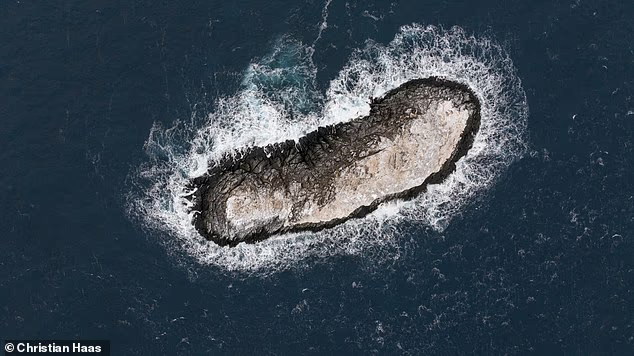
After spotting the landmass, the team carefully steered Polarstern towards it, eventually coming within 150 metres
After spotting the landmass, the team carefully steered Polarstern towards it, eventually coming within 150 metres.
Using a drone, they were able to explore the island from above, confirming its surprisingly large size.
The island measures 130 metres long, 50 metres wide, and protrudes about 16 metres out of the water.
This makes it around the same length as the Great Pyramid of Giza.
The experts are unclear why the island is marked as a danger zone on the nautical chart, but not as a coastline in other data sets.
‘On the satellite images analysed, the island could hardly be distinguished from the numerous icebergs drifting around in the immediate vicinity due to its ice cover,’ they added.
However, before the island can be added to maps, it must be named.
While the team are undecided on what to name the island, many eager fans have already thrown a number of suggestions in the ring on X (formerly Twitter).

Using a drone, they were able to explore the island from above, confirming its size. The island measures 130 metres long, 50 metres wide, and protrudes about 16 metres out of the water. This makes it around the same length as the Great Pyramid of Giza

The experts are unclear why the island is marked as a danger zone on the nautical chart, but not as a coastline in other data sets

A 93–strong team on board the Alfred Wegener Institute’s (AWI) icebreaker, Polarstern, made the discovery after rough weather conditions forced them to seek shelter next to Joinville Island
One user on X suggested: ‘They should call it Eisberg.’
‘It should be called Lummerland,’ another added, in reference to the fictional, two–mountain island from Michael Ende’s children’s book Jim Button and Luke the Engine Driver.
And one joked: ‘Bird Rendezvous Island’.
The news comes shortly after a secret islet appeared off the coast of Venice.
Previously, the islet, called Bacan, would only form in the summer months before being swept away by winter’s storm surges.
But thanks to a new flood barrier this cherished refuge for tourist–shy residents has become a permanent fixture of the lagoon with its own flourishing ecosystem.
Measuring 250 metres long and 10 metres wide, the sandbank is covered with a layer of thick vegetation.
Bacan is now home to a range of marsh plants like samphire, rushes, native flowers, and small, salt–resistant cedars called tamarisk.
With new roots holding the soil in place, the island has not vanished since 2020 when the flood barrier’s operators were away on holiday during a winter surge.
However, even as residents celebrate the birth of a new beach, some experts warn that this could be a troubling sign for Venice’s fragile ecosystem.


