At least three million people in America’s heartland are expected to be in the middle of a deadly tornado outbreak in just hours.
Meteorologists have warned that the extreme weather, which has already been blamed for multiple deaths in the South, has now moved into the Midwest, threatening at least 12 states on Monday, including Missouri, Illinois and Iowa.
Those three states in particular will face the greatest threat of severe thunderstorms, known as supercells, starting Monday afternoon and lasting throughout the night, with the worst of the system centered over St Louis.
Arkansas, Alabama, Indiana, Kentucky, Michigan, Minnesota, Mississippi, Tennessee and Wisconsin are also in the path of the massive storm, which is expected to bring large hail that can shatter windows, torrential downpours and winds over 80mph.
Forecasters have also warned that the roughly 30 million people living in this section of the Midwest may see ‘tornado outbreaks’ tonight, including extremely powerful cyclones that exceed 130mph.
These tornadoes, classified as ‘EF3’ or stronger, are capable of destroying homes and badly damaging large structures such as shopping malls.
AccuWeather Meteorologist Brandon Buckingham warned in a statement: ‘This relentless stretch of severe weather has turned deadly in Texas. It is critical for people in the risk area to have multiple ways to receive warnings, especially overnight.’
‘Be prepared to move to a safe shelter immediately, every second counts during a tornado warning.’
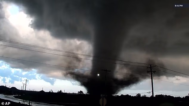
A tornado appeared to strike Oklahoma on April 23. Tornadoes are predicted to strike around the St Louis metropolitan area on Monday

Approximately 30 million people may see extreme thunderstorms, according to meteorologists
The National Weather Service has also issued a ‘hazardous weather’ alert in multiple states, including throughout most of Missouri, where dangerous lightning strikes and potentially deadly flooding on busy roadways have been forecasted.
Millions of Americans in Chicago, Indianapolis, Milwaukee, Nashville and Louisville all face a moderate risk of seeing an extreme storm break out starting around 2pm to 4pm local time on Monday.
The strong storm system has been moving across the US over the last week, pulling in warm and humid air from the south. At the same time, it has slammed into clashing masses of cold air and high winds in the upper atmosphere, creating the perfect recipe for tornadoes.
‘All of the ingredients for a tornado outbreak are coming together across the Midwest,’ Buckingham explained.
‘A strong jet stream, abundant moisture from the Gulf, intense instability and a sharp temperature contrast will fuel storms capable of producing tornadoes, widespread damaging winds and large hail.’
Meteorologists explained that the powerful upward winds inside the storms are strong enough to keep hailstones floating high up in the clouds longer than normal, letting them collect more layers of ice and grow bigger and more destructive.
The giant hailstones may grow to be baseball-size, capable of damaging cars and roofs and smashing through glass structures.
Meanwhile, tornadoes are violently rotating columns of air that swirl down to the ground and usually form during supercells.

Tornadoes in the South and Plains states have destroyed multiple homes over the last week

AccuWeather has warned that the greatest threat of tornadoes touching down on April 27 will be in Missouri, Illinois and Iowa
They are measured in terms of their wind strength, going from EF0, with moderately damaging winds under 85mph, to the most powerful EF5, which exceeds 200mph and can rip buildings off their foundations.
Even if a tornado does not form in some areas, AccuWeather has predicted that wind gusts could reach hurricane strength at more than 80mph.
Storms have already battered the central US over the past week, bringing more than 30 tornadoes and more than 230 reports of hail, according to AccuWeather.
Weather alerts on Sunday came just hours after several twisters swept through parts of Mississippi and Texas, ripping roofs off homes and leaving residential areas reduced to rubble.
At least two people have been killed and several were injured in North Texas over the weekend as tornadoes struck the South.
Although no deaths have been reported, an EF4 tornado, reaching 165 to 200mph, was recorded in Enid, Oklahoma.

A tornado previously touching down in the US Midwest

Hail, described as larger than baseballs, was reported across several states on Saturday, including in Missouri

Severe weather was seen over major outdoor events, including a Kansas City Royals game in Missouri
Monday’s extreme storm throughout the Midwest is expected to be the peak of the past week’s deadly outbreak.
The intensity has been predicted to drop off heading into Tuesday, however, AccuWeather warned that multiple states will still be in the danger zone of severe thunderstorms, hail, floods and isolated tornadoes.
Forecasters said that Monday’s system will shift into the Southeast, threatening Texas, Oklahoma, Louisiana, Arkansas, Mississippi, Alabama, Tennessee, Kentucky and parts of southern Missouri, Illinois, Indiana and Ohio.
‘Damaging winds, large hail and a few tornadoes will be possible near Dallas and Little Rock, as well as along busy stretches of Interstates 30 and 40,’ Buckingham added.


