Sunday, August 2, 2026
No Result
View All Result
LJ News Opinions
  • Home
  • U.S.
  • Politics
  • World News
  • Business
  • Entertainment
  • Sports
  • Technology
  • Health
  • Opinions
  • Home
  • U.S.
  • Politics
  • World News
  • Business
  • Entertainment
  • Sports
  • Technology
  • Health
  • Opinions
No Result
View All Result
LJ News Opinions
No Result
View All Result
Home Opinions

Byran Norcross: Slight chance of a disturbance might sneak across the Atlantic

by LJ News Opinions
August 2, 2026
in Opinions
0
Share on FacebookShare on Twitter


There are no signs of any tropical development well into August, but there are early signs that the eastern Atlantic might become more hospitable to disturbances moving off Africa around the middle of the month. FOX Weather Hurricane Specialist Bryan Norcross joins FOX Weather with his exclusive analysis. 

Updated at 9:45 a.m. ET on Sunday, Aug. 2, 2026.

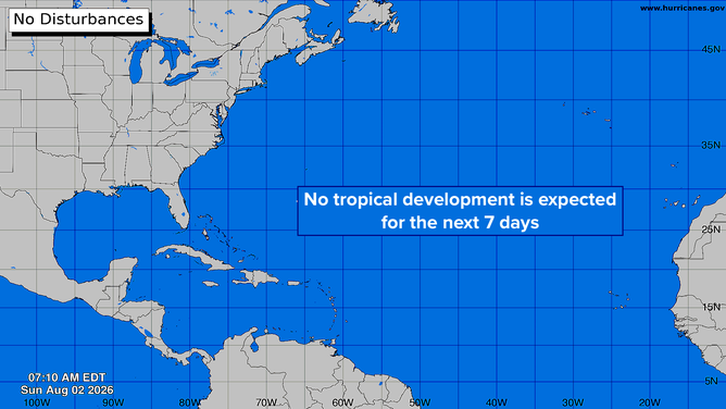
The National Hurricane Center continues to show crickets across the Atlantic, the Caribbean, and the Gulf into next weekend.

A giant Saharan dust cloud dominates the eastern tropical Atlantic, while hostile upper-level winds are eliminating the possibility of development in the Caribbean.

EL NIÑO CONTINUES TO STRENGTHEN TOWARD RECORD TERRITORY TWO MONTHS INTO THE ATLANTIC HURRICANE SEASON

In the far eastern Atlantic, a large disturbance moved off Africa on Thursday. The Saharan dust is making it hard to see, but it’s located just west of the Cabo Verde Islands.

This graphic shows there is no tropical development expected in the next week.

(National Hurricane Center)

The bulk of the disturbance is likely to succumb to the hostile conditions, but some of the computer forecast models indicate that a northern piece of the system could eventually make it to our side of the ocean.

BRYAN NORCROSS: THE TROPICS LOOK TO REMAIN QUIET WELL INTO AUGUST

This is all low-probability business, but the idea is that a moisture surge would arrive in South Florida Thursday or Friday, with the disturbance moving into the Gulf over next weekend.
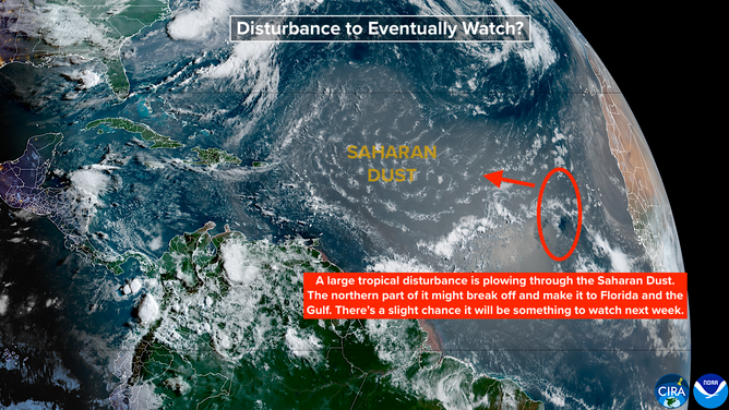
This graphic shows that there is a large tropical disturbance plowing through the Saharan dust.

This is a little bit plausible, because in this scenario the disturbance would migrate west well to the north of the hostile winds across the Caribbean. It would still have to survive its encounter with the Saharan dust, however.

It’s very common for tropical moisture surges to move across South Florida this time of year.

HOW TO WATCH FOX WEATHER

Sometimes they become the seeds for some kind of development in the Gulf. So we’ll keep that in mind as we look toward next weekend and early next week.

Otherwise, enjoy the crickets.


Source link

Tags: ClimateforecasthurricanesoceanStay22USUS Regions
LJ News Opinions

LJ News Opinions

Next Post
Revellers line Amsterdam canal to watch the annual Pride boat parade

Crowds line Amsterdam's canals for Pride boat parade

Recommended

Real Madrid sign Ibrahima Konate to multi-year deal from Liverpool | Football News

2 months ago

Girl, 7, struck, killed by falling boulder at Lake Tahoe ski resort

1 year ago

Popular News

    Connect with us

    LJ News Opinions

    Welcome to LJ News Opinions, where breaking news stories have captivated us for over 20 years.
    Join us in this journey of sharing points of view about the news – read, react, engage, and unleash your opinion!

    Category

    • Business
    • Entertainment
    • Health
    • Opinions
    • Politics
    • Sports
    • Technology
    • U.S.
    • World News

    Site links

    • Home
    • About us
    • Contact

    Legal Pages

    • Privacy Policy
    • Cookie Privacy Policy
    • Terms of Use
    • Disclaimer
    • California Consumer Privacy Act (CCPA)
    • DMCA
    • About us
    • Advertise
    • Contact

    © 2024, All rights reserved.

    No Result
    View All Result
    • Home
    • U.S.
    • Politics
    • World News
    • Business
    • Entertainment
    • Sports
    • Technology
    • Health
    • Opinions

    © 2024, All rights reserved.