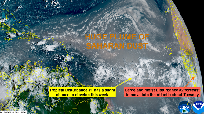
The Atlantic is starting to heat up, with two areas to watch – including one with a medium chance of development. FOX Weather Hurricane Specialist Bryan Norcross joins the team live with the latest:
The National Hurricane Center (NHC) is noting two disturbances over the eastern tropical Atlantic that are worth watching.
Disturbance 1 is very disorganized, and the NHC has put its chances of making it to tropical depression status in the low range. It could bring some beneficial rain to the southern Caribbean islands about midweek. The odds of development are low because it will be plowing into super hostile upper winds as it nears the Caribbean.
Satellite view of Areas to Watch in the Atlantic basin
Disturbance 2 is still over Africa. It will cross the coast into the Atlantic about Tuesday. The computer forecast models show it arriving with a large slug of moisture that could fight off the Saharan dust enough to allow it to develop. Other than the dust, the weather pattern looks conducive to development, and the ocean water that far south is warm enough.
The development chance will begin mid- to late week. If it can avoid enough dust, it could develop into Tropical Storm Dolly, but the road ahead is tough.
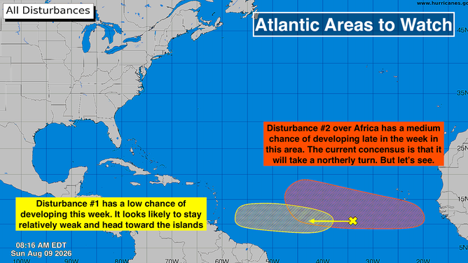
Areas to Watch in the Atlantic basin.
The consensus of the computer forecast models that show it organizing into a coherent system turns the storm north into the open Atlantic. The path ahead is rife with dust and nasty-strong upper winds, so unless it slithers through a temporary gap, it’s going to be tough sledding.
In any case, there’s no indication that it will be a threat to land as a strong storm. Although I hasten to add that forecasts for systems that haven’t even begun to develop are always more uncertain and subject to change.
We’ll see what develops with this one in a few days.
In the Pacific
The eastern Pacific is lit up with potential development areas. The one of interest is the read one – Disturbance 1. This is the disturbance we’ve been following since last week. Computer forecast models indicated that this system will strengthen and head in the general direction of Hawaii.
HAWAII COULD BE IN PATH OF TROPICAL THREAT AS EL NIÑO BOOSTS EASTERN PACIFIC ACTIVITY
Since the system will reach the island from a southeasterly direction, it will track over warm enough waters that it could intensify into a tropical storm or hurricane. On the current schedule, it will arrive in the vicinity of the Hawaiian islands late into the week or over the weekend.
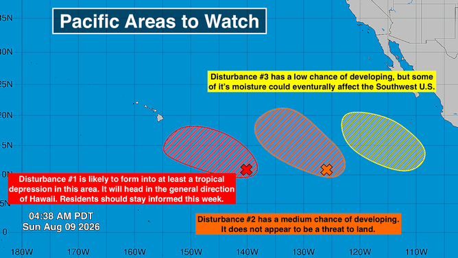
Areas to Watch in the Pacific basin
Some models track the system south of the islands, but some bring it near or over the Big Island heading west. Since the system hasn’t organized yet, so there is no center to track, no reliable forecast is possible.
HOW ARE HURRICANES RATED? THE SAFFIR-SIMPSON HURRICANE WIND SCALE EXPLAINED
The message is that the weather pattern is conducive to a tropical weather system – possibly a tropical storm or hurricane – tracking near or over the islands late in the week or over next weekend. Stay informed and stay aware.
Disturbance 2 has a medium chance of developing. There’s currently no sign of it becoming a threat to land.
Distubance 3 has a low chance of developing, according to the National Hurricane Center. It should stay offshore of Mexico, but some of its moisture might spread into the Southwest U.S. late in the week.