Tropical development odds are ticking up in the Atlantic. The area to watch now has a medium chance of organizing as it could drift into a brief window of more favorable conditions later this week. Full outlook:
Sept. 15, 1926
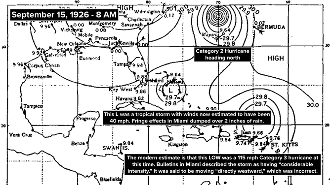
Reports arrived from the northeast Caribbean on Wednesday that the low-pressure system plotted north of the Virgin Islands had “considerable intensity.” Winds at St. Thomas in the Virgin Islands were blowing 40 to 45 mph in the morning. And a nearby ship reported 70 mph winds midday. The storm was thought to be moving “directly” to the west.
The modern estimate is that the system north of the Caribbean was carrying winds of 115 mph on the morning of September 15, and they would continue to increase during the day. The storm was moving north of west, but without satellites and detailed ship reports, there was no way for them to know.
Sept. 15, 1926 Atlantic tropics
(Bryan Norcross)
There was some discussion of the storm in the Miami newspapers, but there was no sense of concern. The morning Herald had a small blurb on page 2 headlined “Storm Is Reported.” But the point of the little story was that there were now three “hurricanes” on the map. They were looser back then with the terms hurricane, tropical storm, and tropical disturbance.
The afternoon Daily News had a larger story about the three storms, but on page 5. Again, there was no sense of a potential threat to Miami.
GET THE LATEST FROM HURRICANE SPECIALIST BRYAN NORCROSS
The Fort Lauderdale paper had a front-page story about the tropical storm in the Bahamas, but there was no mention of the hurricane farther south. The Jacksonville Journal reported an opinion that the hurricane near the Caribbean was going to “pass near here.”
Now we know that the storm was on a beeline for Miami. It would blast ashore three days later and become one of the defining disasters of the era.
In the Atlantic
A non-tropical disturbance in the middle of the Atlantic now has a medium chance of becoming at least a tropical depression later this week into next week, according to the National Hurricane Center.
The models have backed off a bit on the idea of the system developing, but if it does, it could become the first hurricane of the season. It’s moving into an area with light steering currents, so it will probably loop or move erratically for a while.
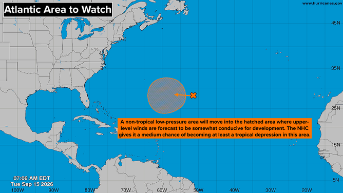
Atlantic Basin on Sept. 15, 2026.
(Bryan Norcross)
In any case, the consensus of the forecasts that show development is that the system will eventually head into the North Atlantic and not be a threat to land. Still, Bermuda should keep an eye on it. When storms haven’t even begun to develop, forecasts can and do jump around.
A non-tropical low-pressure system is forecast to move over Florida late in the week. It’s coming from the north and bringing a core of cool air, so tropical development is not expected. It can, however, produce extra-strong thunderstorms. We’ll see how things develop at the end of the week, but expect an extra rainy stretch on the Florida peninsula.
In the Pacific
The two tropical depressions, Norbert and Fifteen-E, are tracking west into an increasingly hostile atmospheric environment. Both are forecast to lose their tropical identity long before they get near Hawaii. Fifteen-E never quite spun up into Tropical Storm Odalys.
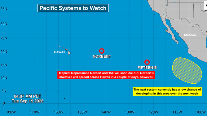
Pacific Basin on Sept. 15, 2026.
(Bryan Norcross)
A new potential development area is on the map. The National Hurricane Center currently has the odds in the low range over the next several days. If this one develops, it looks likely to stay close to the Mexican coast.
Norbert’s leftover moisture is forecast to spread across the Hawaiian Islands Thursday into Friday. The rain could be heavy in some locations, so stay alert for updates from the National Weather Service in Honolulu.