As Hurricane Lowell is poised to take a dramatic turn toward Hawaii, Director of the National Hurricane Center, Michael Brennan, joins FOX Weather as the state remains on alert for intense wind, surf and rain.
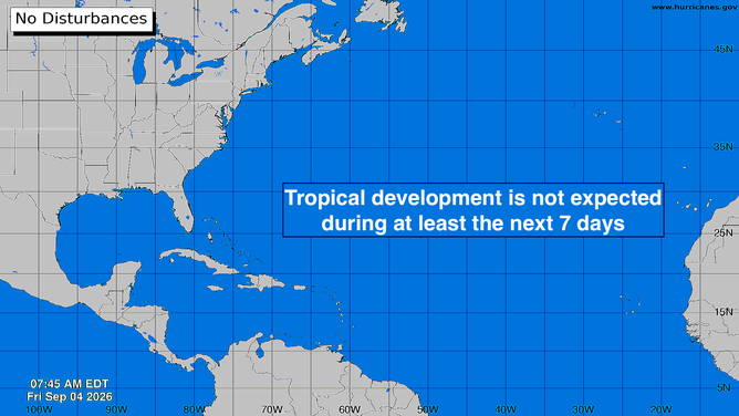
The statistical peak of Atlantic hurricane season is coming up next week, but the weather pattern over the tropical Atlantic has a very wintertime look. A strong band of hostile upper-level winds stretches across the Caribbean and all the way to Africa. This pattern will shut off any possibility of an African disturbance developing as it normally would this time of year.
There are no signs of any potential development areas for at least the next week or 10 days, which would put us into record territory for the satellite era. The latest date for the first hurricane going back to 1966 is September 11. Hurricane Gustav in 2002 and Hurricane Humberto in 2013 both waited until September 11 to form.
Atlantic basin
(Bryan Norcross)
WHAT’S THE DIFFERENCE BETWEEN A TROPICAL DEPRESSION, TROPICAL STORM AND HURRICANE?
In the official record book, which goes back to 1851, 1907 and 1914 had no hurricanes. Obviously, there were also no satellites back then, so nobody thinks the record is necessarily complete. But the point is that a year without hurricanes is meteorologically possible.
This is not a prediction. It’s just a thought based on the official record.
Hurricane Lowell and Hawaii
Powerful Hurricane Lowell is on track to slow down and start its turn to the north tomorrow. On the current schedule, the storm will make its closest approach to the western main Hawaiian Islands on Monday – likely late in the day Hawaii time. Whether the core of the storm with the strongest winds will be offshore is still a bit of an open question.
The consensus of the best computer forecast models is that indeed the worst of Lowell will miss the main Hawaiian Islands. But the forecasts project a track that’s uncomfortably close and the intrinsic uncertainty includes the low-odds possibility of significant impacts on Kauai and lightly populated Niihau just to its west. Honolulu and the south-facing side of Oahu will feel fringe effects, though the degree of impact is not yet certain.
Lowell’s forward speed will slow significantly as it eases into the sharp turn to the north. Whenever a tropical system is moving slowly, its future track becomes more uncertain.
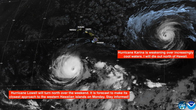
Hurricanes Karina and Lowell near Hawaii
(Bryan Norcross)
LATEST FROM FOX WEATHER HURRICANE SPECIALIST BRYAN NORCROSS
A sharp dip in the jet stream is forecast to dive west of Hawaii over the next few days. It’s that strong flow of air that should grab Lowell and pull it north. Perfectly predicting the path of the hurricane means predicting the exact trajectory of the jet stream dip – thus the above-normal uncertainty.
The official National Hurricane Center forecast is for Lowell to be at Category 2 or 3 strength late Monday when it is closest to Kauai. Strong winds and heavy tropical rains will extend well east of the storm. Whether the worst winds and rain will impact Kauai or Oahu is unknowable, but the current odds say the core of the storm will pass the islands to the west. Niihau, which has much lower mountains, will be closer to the center of Lowell and will likely see worse conditions.
Once Lowell makes its turn on Sunday, it will accelerate to the north, and the forecast should become more certain. That means only one day to prepare if the unexpected happens and the track shifts toward the populated islands. So everybody on Kauai and Oahu should be ready to take action quickly if that becomes necessary.
Preparing at this point means doing what you can now so that taking the required action if the threat materializes can be done quickly and with as little stress as possible.
Elsewhere in the Pacific
Hurricane Karina is weakening and will eventually be absorbed by Lowell well north of the Hawaiian Islands.
Hurricane Marie will track north well offshore of Mexico. Some moisture from Marie may stream over extreme Southern California and into parts of the Southwest over the weekend. Stay aware of the latest forecast if you’re going to be in areas vulnerable to flash flooding.
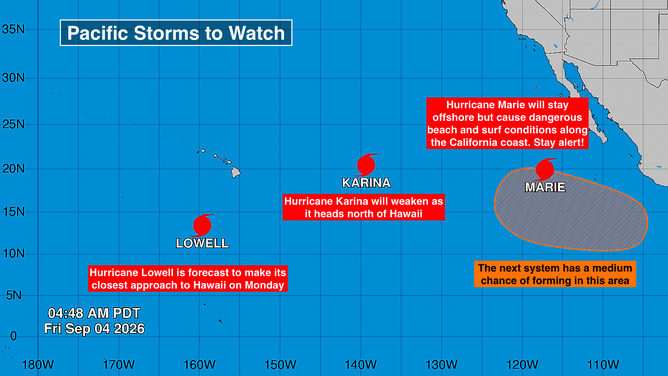
Pacific basin
(Bryan Norcross)
Also strong swells and very high surf caused by Hurricanes Karina and Marie will impact California beaches over the Labor Day weekend. Sneaker waves – rogue waves that suddenly break over jetties or run up on the beach – are also possible. Pay attention to coastal alerts from the National Weather Service.
Another system is forecast to develop behind Marie. We’ll watch to see where its moisture goes in a week or 10 days.
The combination of the El Niño and the marine heat wave from Hawaii to California to the equator means that there is more moisture in any air that flows north across the western U.S. That means the potential for flooding rain is higher this year than normal.