The National Hurricane Center has designated a new area to watch for tropical activity off the coast of the Southeastern U.S. FOX Weather Hurricane Specialist Bryan Norcross gives his expert analysis on what this new area to watch could look like as we head into the holiday week.
Updated at 10:30 a.m. on Saturday, June 27, 2026.
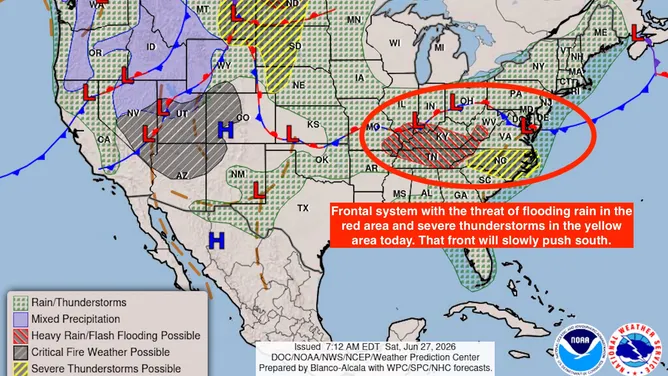
A frontal system that is forecast to bring heavy rain from the Midwest to the mid-Atlantic today will slowly push off the Southeast coast. About Tuesday, a low-pressure system is forecast to develop along what’s left of the front over the very warm Gulf Stream water offshore of South Carolina. This will be non-tropical development, like what happens when a nor’easter develops in the winter.
The warm environment over the Gulf Stream will likely dissipate the front, however, giving the system a chance of taking on tropical characteristics – meaning it will derive its energy from the ocean water and not from the temperature difference across the front.
A look at the frontal system.
(Bryan Norcross / NOAA)
This is a typical scenario for June when fronts from the north still make it far enough south to encounter warm enough water to transition the system into a tropical depression or tropical storm. But the process takes some time.
A number of the computer forecast models don’t think a tropical system will have time to develop before the front dissipates, but interestingly, the AI models from Google DeepMind and the European Centre (the Euro model people) show a chance of a weak tropical system developing about Wednesday or Thursday and tracking toward the Georgia or South Carolina coast.
Because this is a typical scenario for June and at least the AI models support the idea that there’s a slight chance of development, the National Hurricane Center has designated an area to watch for the middle of next week.

New area to watch designated in the Atlantic
(Bryan Norcross / FOX Weather)
Even if a tropical system develops, there’s no indication of it getting very strong. The upper-level winds are only forecast to be conducive to development for a day or so. But it bears watching for residents along the Georgia and Carolina coasts. It could affect beach and boating activities.
The circulation around the heat-dome high-pressure system that’s forecast to bring very hot weather to the Midwest and Northeast will nudge the system, if it develops, back toward the coast.
This should be over and done by the holiday weekend, whatever form it takes.


