Forecasters warned that the dangerous storm system is expected to barrel through Texas and Louisiana before pushing northeast toward parts of Pennsylvania and New York.
Northern Illinois remains the area of greatest concern, where a moderate tornado risk covers about two million people. Kankakee County has declared a state of emergency after at least four twisters struck Tuesday evening.
Tornadoes have already been confirmed in Texas, Oklahoma, Iowa, Illinois and Indiana since Tuesday, and two deaths have been reported in the Lake Village community in Indiana.
AccuWeather Senior Meteorologist Courtney Travis said the midweek threat of storms and tornadoes could become the most ‘widespread and impactful severe weather outbreak so far this year.’
Nearly 210 severe weather reports poured into the National Weather Service (NWS) from Tuesday through early Wednesday morning, the highest number recorded nationwide in 24 hours since July 28.
Major metro areas that could experience severe weather include Houston, San Antonio, Nashville, Pittsburgh, New Orleans, Atlanta and Columbus, Ohio.
The first round of storms could arrive during the early morning hours, roughly between 4am and 10am, across parts of the Midwest and central United States.
The greatest tornado threat is expected later in the day, when warmer temperatures and unstable air allow storms to intensify from the afternoon into the evening.
Kankakee County has declared a state of emergency after at least four twisters struck Tuesday evening (PICTURED)

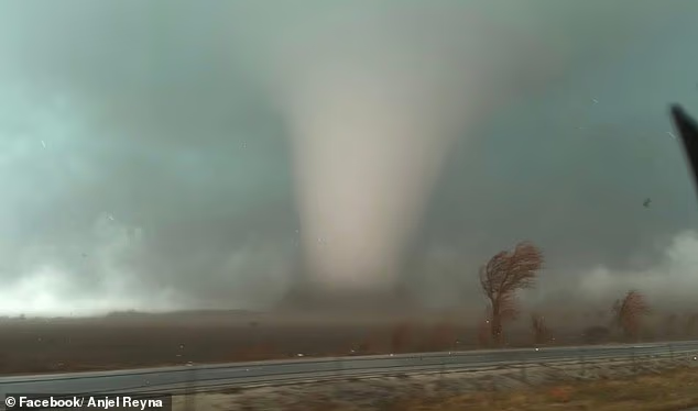
Tornadoes were reported Tuesday evening in Oklahoma (PICTURED)
Forecasters are especially concerned about the possibility of nighttime tornadoes, which are harder to detect and more dangerous because people are often asleep when warnings are issued.
The Storm Prediction Center has placed a large area stretching from the Lower Mississippi Valley through the Ohio Valley and into the Mid-Atlantic under a Slight Risk for severe thunderstorms.
Tornado chances in some areas range between two and nine percent, meaning a tornado could occur within about 25 miles of any given location in the highlighted zones.
While tornadoes are possible, forecasters warned that damaging straight-line winds are expected to be the most widespread threat across much of the region.
Gusts of 65 to 70 mph, along with power outages, were reported in parts of southern Illinois early Wednesday morning as the line of storms swept through.
The Weather Channel also reported scattered severe storms developing across parts of the South.
‘In general, Wednesday’s primary severe threat will be damaging thunderstorm wind gusts from parts of the Appalachians and Mid-Atlantic to the Lower Mississippi Valley,’ meteorologists with The Weather Channel said in a statement.
Forecasters say tornadoes remain possible across several regions, and a strong tornado rated EF-2 or higher cannot be ruled out, particularly across parts of the upper Ohio Valley, the northern Appalachians and the lower Mississippi Valley.

Northern Illinois remains the area of greatest concern, where a moderate tornado risk covers about two million people. The region experienced twisters on Tuesday evening, destroying several homes

Giant hail is expected in several US states. Pictured is hail in Kankakee County, Indiana on Tuesday

Forecasters warned that the dangerous storm system is expected to barrel through Texas and Louisiana before pushing northeast toward parts of Pennsylvania and New York
An EF-2 tornado is considered a ‘strong’ tornado, with estimated three-second wind gusts between 111 and 135 miles per hour.
Storms of that strength can cause considerable damage, including tearing roofs off homes, destroying mobile homes, snapping large trees and lifting vehicles.
Severe thunderstorms are also expected to continue well into the night, stretching from the Mid-Atlantic and Appalachian regions through the Tennessee Valley and into parts of the Southeast and northern Gulf Coast.
Some of these storms could still produce damaging winds, hail and isolated tornadoes as the system moves east.
Weather officials warn that conditions can change quickly, and tornado watches or warnings may be issued with little notice, sometimes giving residents only 13 to 30 minutes of lead time to seek shelter.
Residents across the affected regions are urged to stay alert and monitor updates from the National Weather Service and local weather alerts throughout the day.


