A storm system moving down the coast will bring rain to Southern California on Wednesday along with a chance of thunderstorms and even a “remote risk of tornadoes” by Thursday, the National Weather Service (NWS) said.
“The rain will reach L.A. County around noon. Rain will turn to showers during the afternoon everywhere except L.A. County where steady rain will linger into the evening,” the NWS said in its forecast discussion Wednesday morning.
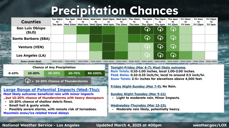
Residents in Southern California’s burn areas are preparing for possible debris and mud flows but the NWS believes the storm’s most likely outcome will be “beneficial rain” with only minor impacts.
Range of potential impacts Wed-Thur:
- 10 to 20% chance of shallow debris flows
- small hail and gusty winds
- possibly severe storms with a remote risk of tornadoes
The NWS says the “system will not be that much of a rainmaker producing only a third to two-thirds of an inch of rain.” There is a 10 to 20% chance of thunderstorms with heavy downpours that could allow some local amounts to reach between 1 and 2 inches.
“Thursday there’s just enough instability in the atmosphere that we’re seeing isolated chances of thunderstorms and potentially even weak tornadoes,” KTLA’s Kirk Hawkins said.
Snow totals should remain between 2 and 5 inches for elevations above the 4,500-foot mark.
Dry and clear skies are likely to return Friday afternoon through Sunday before another series of storms arrives next week.
Light to moderate showers are forecast to return overnight Sunday through Tuesday with a stronger storm bringing potentially heavy rain next Wednesday and Thursday.


