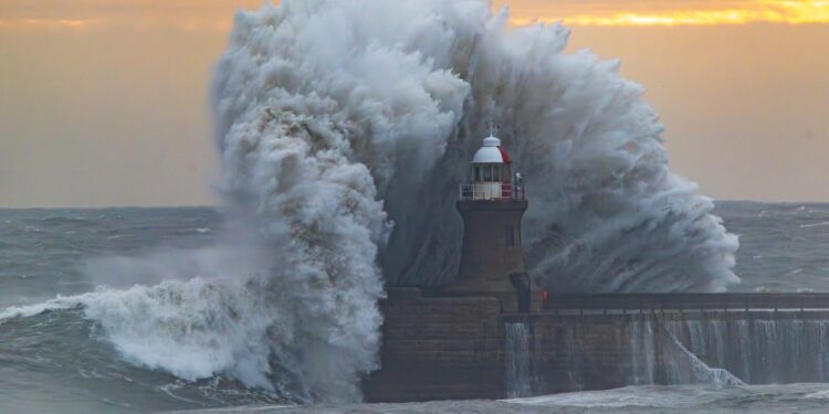
BRITS have been warned to brace for 80mph gales, heavy rain and travel chaos as Storm Ashley is set to batter the UK this weekend.
The Met Office has warned of “very strong and gusty southerly winds” as the rapidly “intensifying” weather pattern hits tomorrow.
It comes as a deep area of low pressure will arrive from the Atlantic bringing Storm Ashley with widespread strong winds, particularly in northern and western areas.
Meteorologist Alex Deakin said in a forecast: “There’s quite a powerful storm developing mostly to the west of the UK.
“The central pressure has dropped down by Saturday morning in the space of a day, intensifying as the storm system approaches.
“It will bring some potentially damaging gusts of wind across the Republic of Ireland but also across some parts of the UK.
“It’s on Sunday we are particularly concerned about. Saturday will be a nice day, dry and bright.
“But on Sunday, parts of north west England, north Wales, Northern Ireland and Scotland could see some damaging gusts of wind.
“We can see gusts close to 90mph offshore, but across parts of Scotland we could see gusts of 60, 70, perhaps 80mph on Sunday afternoon into the evening.
The Met Office has issued an amber weather warning for wind on Sunday, covering parts of Scotland and the Scottish Highlands.
It comes into force at 9am and finishes at midnight the same day.
Meteorologists predicts gusts could reach up to 80mph in exposed areas.
Those affected can expect power cuts, and disrupted mobile phone coverage.
Public transport services will also likely ben delayed or cancelled, with roads and bridges predicted to close.
The Met Office warning reads: “Injuries and danger to life is likely from large waves and beach material being thrown onto coastal roads, sea fronts and properties.
“Probably some damage to buildings, such as tiles blown from roofs.”
There is also a yellow weather warning for wind covering larger areas of the UK, including all of Scotland, Northern Ireland, and the western coast line stretching down past the midlands to Wales.
This notice last from 3am on Sunday until midnight.
Areas affected by the amber warning
Highlands & Eilean Siar:
- Na h-Eileanan Siar
- Highland
Strathclyde:
Storm Ashley will continue to bring strong gales into Monday next week, with another yellow weather alert in force.
It is in place over the Scottish Highlands again from midnight until 9am.
Chief Meteorologist Jason Kelly said: “A period of strong south to southeasterly winds is likely across western Scotland on Friday morning into the early afternoon, before easing and turning southwesterly through the afternoon.
“Wind gusts of 45-55mph are possible fairly widely for a time, and perhaps in excess of 60mph in more exposed locations.
“Given the wind direction and high spring tides, some disruption is possible.”
Transport Scotland has warned of likely disruptions to public transport, including the country’s ferry network.
A statement said: “A windy period is expected across the whole of the UK on Sunday and into Monday, but across parts of Scotland, Northern Ireland, north-west England and north-west Wales there is an increased chance of some disruption.
“These strong winds in conjunction with high spring tides may cause some disruption.”
Meanwhile, in the south of England conditions appear drier, with temperatures hovering at just above seasonal average.
However, much of the south and south east will be lashed with heavy rain this morning.
Those across the Midlands and Manchester are also forecast torrential downpours until around midday.
Conditions are set to clear up by the afternoon, with only a few intermittent showers expected in the north until Storm Ashley arrives tomorrow.
Much of the UK is predicted sunny spells today, in between cloud cover.
Brits in the south of England are due to feel highs of 17C, while lows of 11C are forecast in Scotland, elsewhere figures will hover at around 14C for most.
Staying safe in strong wind
Source; The Met Office
Protect your property from damage and other people from injury
Secure items such as;
- bins
- plant pots
- garden furniture (bring inside or secure in place)
- trampolines (turn upside down or secure with tent pegs)
- sheds (ensure doors are locked)
Follow simple steps to prepare before journeys
- Plan your route, check for delays and road closures
- Listen out for travel updates on your car radio/sat nav
- If you don’t have essentials in your car then pack for the worst (warm clothing, food, drink, blanket, torch)
- Take a fully charged mobile phone with an in-car charger or battery pack
If you must drive, you can do this more safely by:
- Driving slowly to minimise the impact of wind gusts
- Be aware of high sided vehicles/caravans on more exposed roads
- Be cautious overtaking high sided vehicles/caravans
- Make sure you hold the steering wheel firmly
- Give cyclists, motorcyclists, lorries and buses more room than usual
Staying safe when you’re at the coast
- Check the forecasts and tides in your local area here
- Beware of large waves, even from the shore large breaking waves can sweep you off your feet and out to sea
- Take care if walking near cliffs – know your route and keep dogs on a lead
- In an emergency 999 (UK) or 112 (Ireland) and ask for the Coastguard
Avoiding injury if you’re out and about
Being outside in high winds makes you more vulnerable to injury. Stay indoors as much as possible. If you do go out, try not to walk or shelter close to buildings and trees.


