SEVERE WEATHER HQ: FOX Weather Meteorologist Bayne Froney breaks down the upcoming intense weather threat spanning across the American Heartland Sunday evening and into Monday, as over 16 million people are under a 3/5 severe windstorm threat.
Another round of severe weather is headed from the Heartland to the East Coast, with powerful winds expected to impact the region on Monday.
A renewed severe weather threat is ongoing in the U.S. as an intense blizzard sweeps through the Great Lakes region this weekend.
The powerful winter storm is already approaching 2 feet of snow accumulation in both Wisconsin and Minnesota.
FEROCIOUS STORM 🧊🌊: Giant waves of slushy ice crash along the shores of Lake Michigan as a life-threatening blizzard slams the region with no signs of slowing down. Stay tuned with FOX Weather all day long as we cover this fast-moving storm.
Notably, Michigan Governor Gretchen Whitmer has activated the State of Emergency Operations Center due to the life-threatening impacts of this storm and the risk of widespread outages, with over 10,000 people currently without electricity.
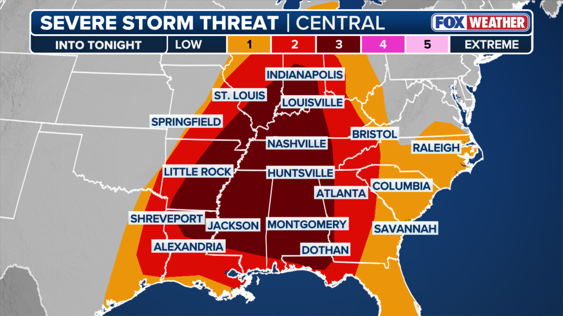
Looking to the lingering severe threat beginning Sunday evening, a Level 3/5 severe risk is in place with the focus of 70 mph damaging winds and strong tornadoes.
Sunday sets up a powerful storm system that moves through the Great Plains toward the Great Lakes. According to the FOX Forecast Center, this sort of movement pulls warm, moist air up from the Gulf of America, creating a narrow corridor of instability.
“While the moisture isn’t exceptionally deep, the sheer speed of the winds aloft is enough to overcome that limitation,” the FOX Forecast Center said. “As a result, a widespread line of intense thunderstorms, known as a squall line, is expected to form along a cold front and sweep through the Mid-South and Ohio Valley.”
WHAT IS A SQUALL LINE AND WHY IS THIS TYPE OF SEVERE WEATHER SO DANGEROUS?
(FOX Weather)
These storms could easily produce wind gusts of 60 to 70 mph, enough to bring down trees and power lines.
The timing of the storms on Sunday is important to their development, as they shift into the overnight hours and into Monday morning across the Deep South.
Cities with Level 3/5 severe weather risk include Indianapolis, Memphis, Nashville, Tennessee, Louisville, Kentucky, and Little Rock, Arkansas.
Monday severe threat
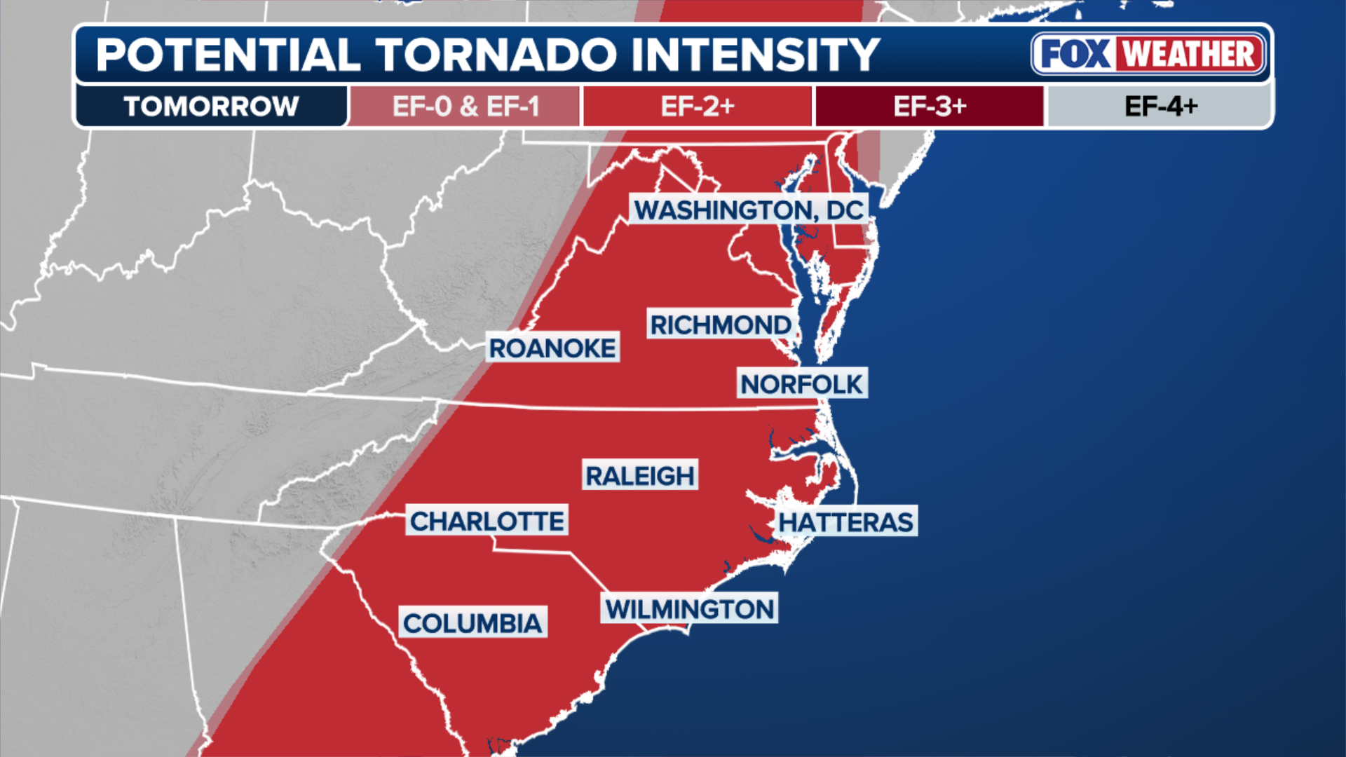
For Monday, the severe threat increases to 4/5, as the same storm system from Sunday will bring intense thunderstorms overnight, and a significant storm system is expected to sweep across the East Coast, bringing dangerous winds and strong tornadoes.
This threat includes popular locations such as Washington, D.C., which could experience damaging winds over 70 mph and many long-track tornadoes.
As a cold front pushes into the eastern U.S., it will trigger a widespread, fast-moving outbreak of severe weather from Georgia to Pennsylvania.
Meteorologists at the FOX Forecast Center report that the main concern will be a massive line of storms capable of producing damaging straight-line winds. These gusts will be moving at 60 to 80 mph, which can easily damage structures and cause widespread power outages.

(FOX Weather)
In addition to the wind threat, the atmosphere is showing a high degree of wind shear, or twisting of the winds with height. Experts say that this could mean any individual storm that forms ahead of the main line could rotate and produce tornadoes.
The focus for Monday will begin in Georgia and the Florida Panhandle, where supercells could produce tornadoes and large hail early in the day.
By the afternoon, the threat will shift into South Carolina, North Carolina, Virginia and Maryland.
(FOX Weather)
According to the FOX Forecast Center, these fast-moving storms will be moving over 60 mph and will give people very little time to react once warnings are issued.
It is important to plan by stocking up on essential supplies, such as food, water, batteries for a flashlight and other essentials, in case you lose power.
This threat area will stretch from major cities such as New York City and Washington, D.C., down to Raleigh, North Carolina, and Columbia, South Carolina.
TORNADO SAFETY: THE SAFEST AREAS TO PROTECT YOURSELF AND WHY TO AVOID OVERPASSES
Stay tuned to FOX Weather as we continue to track these severe storms for the latest developing news and updates.


