Friday, March 6, 2026
No Result
View All Result
LJ News Opinions
  • Home
  • U.S.
  • Politics
  • World News
  • Business
  • Entertainment
  • Sports
  • Technology
  • Health
  • Opinions
  • Home
  • U.S.
  • Politics
  • World News
  • Business
  • Entertainment
  • Sports
  • Technology
  • Health
  • Opinions
No Result
View All Result
LJ News Opinions
No Result
View All Result
Home Opinions

New tropical disturbance being tracked in Gulf

by LJ News Opinions
October 6, 2025
in Opinions
0
Share on FacebookShare on Twitter


The National Hurricane Center has highlighted a new area of possible tropical development to watch in the Bay of Campeche.

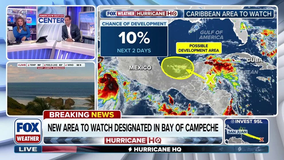
MIAMI – A disturbance off Central America has been highlighted for the possibility of tropical development as it moves into the Gulf of America this week.

The National Hurricane Center said Monday that a disorganized area of showers and storms could slowly develop as it moves across the Yucatán Peninsula and Bay of Campeche through Wednesday.

Meteorologists have given the disturbance a low chance of developing.

HOW TO WATCH FOX WEATHER

The outlook for a disturbance near Central America.
(FOX Weather)


“Regardless of development, areas of heavy rain and gusty winds are likely across portions of the Yucatan Peninsula, Belize, and southern Mexico during the next few days,” NHC forecasters wrote in their outlook.

Forecasters are also monitoring Invest 95L in the Central Atlantic, which has a high chance of development.

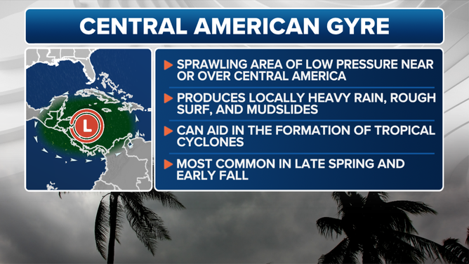
What is the Central American Gyre?

The disturbance has spun off what forecasters call the Central American Gyre, or CAG.

The broad area of low pressure typically develops once or twice during the early and late months of hurricane season. 

A CAG can trigger a range of hazardous weather besides tropical cyclones, including torrential rain, flooding and mudslides.

DOWNLOAD THE FREE FOX WEATHER APP

Central American Gyre

Central American Gyre

(FOX Weather)

About once every other year, a tropical cyclone emerges from one of these gyres and strengthens into a hurricane if atmospheric conditions allow. 

Some of the most notable examples include Hurricane Michael (2018), which struck the Florida Panhandle as a Category 5 hurricane after spending days embedded in a CAG. Tropical storms Amanda and Cristobal, both in 2020, also developed from similar setups, as did Tropical Storm Andrea in 2013 and Hurricane Ida in 2009.


Source link

LJ News Opinions

LJ News Opinions

Next Post

Trump and Brazilian President Lula have 'friendly' call

Recommended

Boy dead after multi-vehicle, wrong-way crash on Long Island

2 years ago

Why has Venezuela banned six international airlines amid US tensions? | Aviation News

3 months ago

Popular News

    Connect with us

    LJ News Opinions

    Welcome to LJ News Opinions, where breaking news stories have captivated us for over 20 years.
    Join us in this journey of sharing points of view about the news – read, react, engage, and unleash your opinion!

    Category

    • Business
    • Entertainment
    • Health
    • Opinions
    • Politics
    • Sports
    • Technology
    • U.S.
    • World News

    Site links

    • Home
    • About us
    • Contact

    Legal Pages

    • Privacy Policy
    • Cookie Privacy Policy
    • Terms of Use
    • Disclaimer
    • California Consumer Privacy Act (CCPA)
    • DMCA
    • About us
    • Advertise
    • Contact

    © 2024, All rights reserved.

    No Result
    View All Result
    • Home
    • U.S.
    • Politics
    • World News
    • Business
    • Entertainment
    • Sports
    • Technology
    • Health
    • Opinions

    © 2024, All rights reserved.