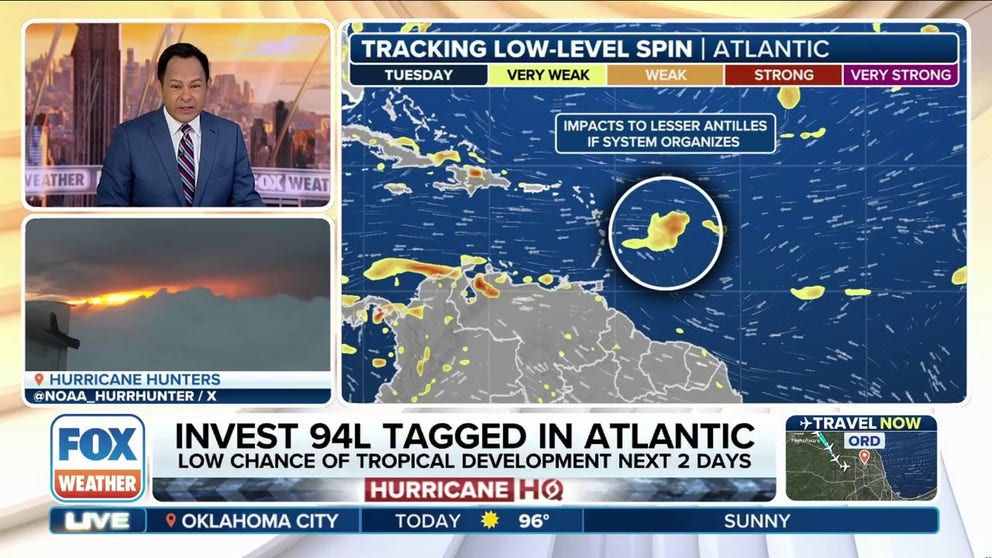
The National Hurricane Center (NHC) has officially designated a new disturbance, Invest 94L, in the Main Development Region of the Atlantic Basin between Africa and the Caribbean islands. It’s expected to have a brief period of strengthening over the next couple of days before encountering unfavorable conditions.
Originally, the NHC had dropped the odds of development to 10%, but after a period of organization on Sunday, the odds were increased to 20%, and the decision was made to tag the tropical disturbance as an invest.
More computer forecast modeling will be done now as it approaches the Caribbean, the FOX Forecast Center said. Unlike the tropical disturbances that fizzled out in recent weeks, Invest 94L will gain some latitude thanks to a break in the strong Bermuda high to the north.
2025 ATLANTIC HURRICANE SEASON GUIDE: HERE’S WHAT TO KNOW ABOUT THE TROPICS THIS YEAR

(FOX Weather)
That weakness in the high will slow the system down and allow a small bubble of moisture to form around it. As it becomes more isolated from the main belt of storms that is always present in the Atlantic, a weak area of low pressure could try to develop as it approaches the Caribbean. Any tropical development, however, would likely be short-lived.
While the environment may briefly become somewhat favorable, a large area of dry, dusty air is lurking just to the north. If a low does form, that dry air could easily wrap around into the system’s center and cause it to weaken quickly.
Additionally, the FOX Forecast Center said this tropical disturbance is headed straight for the Caribbean, which is a notoriously tough environment for developing storms.
WHY THE EASTERN CARIBBEAN IS KNOWN AS THE ‘HURRICANE GRAVEYARD’
Strong trade winds are still racing across the region, creating fast-moving background flow and high wind shear. In addition, tropical systems need time and slow movement to organize.
Even if this system were to briefly become tropical, it would have no future impact on the U.S.
Tropical-like rain trapped under heat dome to blanket Gulf Coast
By Tuesday and into Wednesday, a new area of low pressure may develop in nearly the same spot where Invest 93L formed just last week, the FOX Forecast Center noted.
A cold front is expected to stall along the Southeast coast, and the new low could form over the warm waters just offshore. While some spin is likely, the system is expected to remain broad and disorganized, with no signs of quick strengthening. It will likely get trapped under a growing heat dome and be steered westward, crossing Florida and hugging the Gulf Coast.

(FOX Weather)
Tropical-like downpours are possible from Florida through Louisiana, especially along the Interstate 10 corridor from Tallahassee to New Orleans. Driving conditions could turn very soggy by midweek and remain wet through at least Friday.
Right now, the chance of tropical development remains low. The same limiting factors that held back Invest 93L are still in place: limited time over water, nearby land interaction and steady wind shear out of the northeast.
These conditions are expected to continue or even worsen later in the week. On top of that, the circulation looks fairly large, which generally works against quick tropical development, the FOX Forecast Center said.
Rainfall totals of 2-3 inches are possible for much of the northern Gulf Coast, with some spots potentially seeing more. Widespread flash flooding isn’t expected, but isolated issues may pop up if heavy rain sits over the same area for too long.


