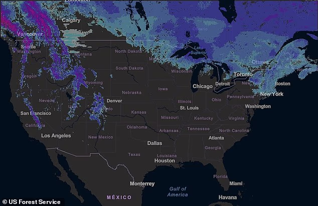
A sprawling blast of winter weather is sweeping across the US, unleashing snow, dangerous winds and treacherous travel conditions.
Parts of Washington, Oregon, Montana and Wyoming are under multiple winter weather advisories until Friday, with regions expected to see two to four feet of snow and winds up to 55 mph throughout the week.
Officials are urging motorists to delay travel if possible, as heavy snowfall and low visibility threaten to make driving extremely dangerous.
Forecasters warned the powerful system could create whiteout conditions in mountainous areas, while snow-covered roads and slick highways may disrupt travel for days.
The most intense snowfall is expected across the Cascade Mountains, where several feet of snow could pile up through the end of the week.
In some mountain passes, rapidly falling snow and powerful winds could make travel conditions ‘difficult to impossible,’ according to the National Weather Service (NWS).
Drivers traveling through high elevations are being warned to prepare for sudden drops in visibility and icy road conditions.
The dangerous conditions could lead to road closures, delays and hazardous commuting conditions across parts of the West.
Parts of Washington, Oregon , Montana and Wyoming are under multiple winter weather advisories until Friday, with regions expected to see two to four feet of snow and winds up to 55 mph throughout the week
The most significant impacts are expected in the Washington Cascades, where a winter weather advisory is in effect for the upper slopes of the eastern Cascades crest, including areas near Easton and Roslyn.
Forecasters said eight to 14 inches of snow could fall through Tuesday, accompanied by wind gusts up to 40 mph.
But conditions could escalate dramatically later in the week.
The National Weather Service (NWS) has issued a winter storm watch from late Tuesday night through Friday morning, warning that two to four feet of snow could accumulate in the mountains.
Winds could also intensify during the storm, with gusts potentially reaching 55 mph, which could significantly reduce visibility and create dangerous travel conditions.
‘Significant snowfall with periods of heavy snowfall rates will combine with low visibility to create difficult driving conditions,’ the National Weather Service warned.
Other parts of Washington are also expected to see accumulating snow.
In the south Washington Cascades, including areas near Mount St. Helens, forecasters expect six to ten inches of snow through Tuesday, along with wind gusts up to 35 mph.

Officials are urging motorists to delay travel if possible, as heavy snowfall and low visibility threaten to make driving extremely dangerous
Another round of heavier snowfall could follow later in the week as the storm strengthens.
Across the border in Oregon, the north Oregon Cascades, including Government Camp and areas near Lost Lake and Timothy Lake, are forecast to receive four to ten inches of snow between Monday morning and Tuesday evening.
Winds in the region could gust up to 40 mph, potentially making mountain roads slick and hazardous.
Officials warned that bridges and overpasses are especially vulnerable to freezing conditions, which can make them dangerously icy for drivers.
Meanwhile, parts of Montana and Wyoming are also under winter weather advisories as snow spreads across portions of the northern Rockies.
In southern Big Horn County in Montana and the Sheridan foothills of Wyoming, forecasters expect one to three inches of snow, with up to five inches possible in higher terrain through Wednesday morning.
The nearby Bighorn Mountains could receive four to eight inches of snow, while winds may gust up to 30 mph, potentially creating difficult travel conditions along US Highway 14.
Weather officials said even relatively modest snowfall can create dangerous driving conditions, particularly as temperatures fall and roads quickly become icy.
Drivers traveling through affected areas are being urged to slow down and use caution, while those crossing mountain passes are advised to carry emergency winter kits that include blankets, water, food, flashlights and tire chains.
Forecasters said the storm system is expected to intensify later this week in the Pacific Northwest, raising the possibility of feet of additional snow in the Cascades and continued dangerous travel conditions across the region.


