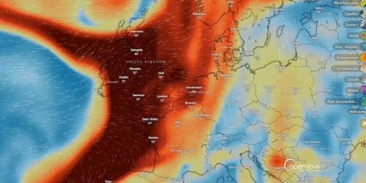
BRITS have been warned of a sulphur dioxide plume already looming over Britain after a volcanic eruption 800miles away.
The Met Office confirmed a cloud of SO2 was triggered by huge seismic activity on Reykjanes Peninsula, near Grindavik, in Iceland on Thursday.
Sulphur dioxide is usually formed by burning coal or crude oil but is also released by volcanos.
It can spark a range of symptoms from a sore throat to burning eyes, or flu-like symptoms including a runny nose and coughing.
In cases where someone comes into direct contact with the gas over a period of time, it is associated with lung conditions such as asthma and chronic bronchitis.
Those who are most vulnerable, young children and the elderly, are advised to pay particular attention to SO2 warnings.
It is understood the sulphur dioxide first passed over the UK at around 4am.
But, air pollution levels have been recorded as “low” and it does not appear to be a cause for concern.
A Met Office spokesperson told The Sun: “A sulphur dioxide plume which originated from the volcano in Iceland has been crossing the UK high up in the atmosphere and will clear to the southeast in the coming hours.
“Impacts have been low from this sulphur dioxide, as it is high in the atmosphere and is having little influence on ground-level air quality. Small concentrations at surface level mean that the air pollution levels remain low.
“Air pollution is currently Low, and expected to remain that way for the whole of the UK today.
“We’re continuing to monitor any sulphur dioxide release originating from Iceland, with current forecasts suggesting little influence on UK surface air pollution in the coming days.”
The Reykjanes Peninsula has been hit by six volcanic eruptions since November last year.
A state of emergency was called on May 29, 2024, after lava spewed into the air from the Sundhnúkur crater row.
The eruption site was situated just a few kilometres northeast of Grindavik, a coastal town with a population of 3,800 people, which has been evacuated.
Grindavik was previously evacuated in November 2023 after a series of earthquakes, which opened large cracks in the ground between the town and Sýlingarfell — a small mountain located to the north.
Before all of the recent eruptions, the Svartsengi volcanic system north of Grindavik had been dormant for roughly 780 years.
Icelandic authorities declared a state of emergency during the November eruption after hundreds of small earthquakes shook the Reykjanes Peninsula — Iceland’s most populated region.
It comes as the Met Office revealed the exact date summer will return.
Weather maps are expected to turn orange as figures rise to 27C – but downpours will hit first.
While the aftermath of Storm Lilian continues to batter Brits, the start of the week – despite being wet – will feel slightly warmer than this weekend.
And as higher pressure moves in from Europe on Tuesday, brighter days appear to be ahead of us.
On Tuesday, southern parts of England can prepare to hit 24C as winds calm down and drier conditions move in.
Temperatures will then soar to 27C on Wednesday in London while surrounding areas are expected to top 26C.
The West Mids is predicted to reach 24C with Northampton and Milton Keynes just 1C higher, say the weather service.
Unfortunately, warmer conditions will drop off slightly by Thursday however, will still remain in the low 20s for most parts.
Met Office Meteorologist Annie Shuttleworth said: “Next week is looking much drier and more settled than this week.
“From Tuesday, low pressure is centred up to the north and west of the UK.
Five-day weather forecast
Today
Bright start for many but cloud building from the west, accompanied by rain and showers. Best of the drier weather across southern England. Feeling rather cool with a brisk wind and temperatures a little below the seasonal average.
Tonight
Cloudy across Northern Ireland, central/southern Scotland and northern England, though with rain becoming more patchy. Clear spells and variable cloud elsewhere with winds easing towards dawn. Milder than last night.
Monday
Showers drifting into western coastal regions, then rain arriving into the northwest for evening. Elsewhere, dry and breezy with patchy cloud and bright or sunny spells. Warmer than Sunday.
Outlook for Tuesday to Thursday
Heavy rain and strong winds move into the northwest on Tuesday, easing as it slowly moves eastwards over the coming days. Mostly dry in the southeast and becoming very warm.
“But high pressure from Scandinavia will pick up warmer air for the week – bringing more settled weather to eastern and southern areas of the UK – lasting into the first week of September most likely.
“So any weather fronts coming to the north west will bump into this high pressure and stop where they are.
“By the time we get to Friday, we will see high pressure likely dominating a bit more widely across the UK.
“So that leads us into the very end of summer which means we could start to see some warmer air moving up from the south and east.
“That does mean it looks quite a lot warmer this week so there’s improvements to come before summer is out.”


