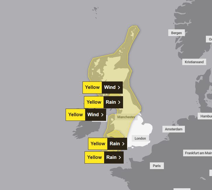
BRITS are bracing for 70mph winds and 12 hours of rain tomorrow, as the Met Office issues warnings across almost the entire UK.
A new map shows large swathes of the country covered by the yellow weather warnings – including England, Scotland, Wales and Northern Ireland.

3

3

3
Southwest England and south Wales will be hit by a nine to 12-hour deluge of rain over the course of the day.
Rain warnings are in place between 9am and 9pm, as residents are warned of potential flooding to homes and roads in those areas.
They have also been told to expect travel disruption – with bus and train services affected – as well as possible power cuts.
In the southwest, including Plymouth and Exeter, 50 to 70mm of water is expected to fall – with 30 to 40mm in other areas.
And in Wales, 30 to 50mm is predicted – with as much as 90mm on higher ground.
A third rain warning is in place in Scotland, covering Wigtown and Dumfries, between 7am and 3pm tomorrow.
As much as 50mm of rain may fall in some areas, according to forecasters, with locals advised to prepare for travel disruption and road flooding.
Meanwhile, a wind warning covers almost the whole of England – except the southeast – between 6am and 6pm.
Gusts of up to 70mph could see road, rail, air and even ferry services delayed.
These should then ease throughout the afternoon and early afternoon.
A second wind warning is also in place across the majority of northern Ireland.
However, Brits will enjoy milder conditions today, with a few showers in the north and west, building slightly into this afternoon.
These will ease off again into this evening, with blustering winds building over the course of the night.
Expanding on the weekend forecast, Met Office meteorologist, Steve Willington, said: “As we shift from a cold easterly weather regime to milder westerly conditions, the Atlantic air brings with it some potentially impactful weather.
“Over the coming days, successive weather fronts bring strong winds and bands of rainfall across the UK with a risk some areas, particularly in the west later in the weekend, could see some low or even medium impacts.
“Weather warnings have been issued to highlight the potential for travel disruption, dangerous conditions near coasts and the possibility of power cuts for some.
“Temperatures are also on the rise as part of this change, possibly peaking at 16°C in sheltered areas to the east and north of high ground today and on Friday, which is well above average for the time of year.”
It comes after yesterday saw a washout across large parts of the UK.
In a post on X, the weather agency said: “Wet and windy to kick off Friday.
“Heavy pulses of rain will be accompanied by gales around coasts and hills.”
5-day forecast
Today
A bright start for many with sunny spells and showers, mainly in the north and west, but these will become a little more widespread during the afternoon. Cloudier in the southeast to start with rain slowly clearing eastwards. Staying mild.
Tonight
Showers will tend to fade with most places becoming dry with clear spells tonight. Cloud will build from the west later with winds strengthening as gales developing in the west.
Sunday
Unsettled on Sunday with wet and windy weather spreading across all parts of the country during the day. Turning drier and brighter from the west later with blustery showers.
Drier on Monday and Tuesday with sunny spells and showers, these locally heavy and slow to clear at times. Mostly dry and sunny for a time on Wednesday. Mild throughout.


