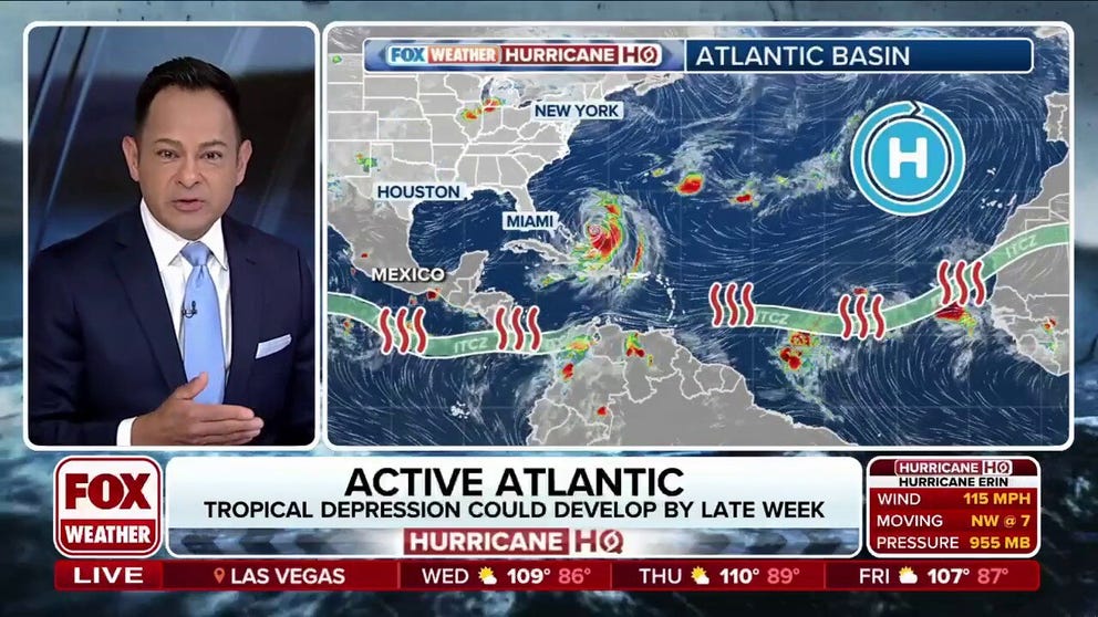
Outside of Hurricane Erin in the western Atlantic, the National Hurricane Center is monitoring two areas of disturbed weather in the Atlantic Ocean, but forecasters say neither appears likely to develop into a tropical cyclone that would immediately threaten any landmasses.
The first disturbance, located near longitude 45 degrees west, or roughly 1,000 miles east of the Lesser Antilles, remains broad and disorganized.
The disturbance has been given a medium chance of development over the next several days, but the FOX Forecast Center said that, given its current structure of being spread out, it would take until at least the end of the week to consolidate into a tropical depression or tropical storm.

(FOX Weather)
Even if the feature were to further organize, most computer forecast models suggest it would take a more northward track, potentially impacting the northern Caribbean islands but staying well away from the continental United States.
Significant troughiness over the northeastern U.S., which is even seen in the NOAA climate outlook, is expected to serve as a mechanism to steer any tropical development northward.
The weather pattern is expected to allow air temperatures to dip into the 40s and 50s across a large section of the country, a sign that fall is quickly approaching.
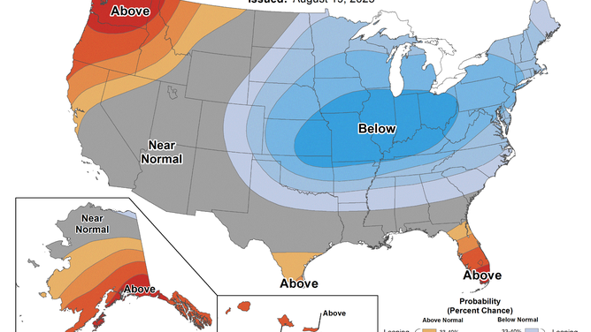
NOAA Temperature Outlook
(NOAA)
Another factor working against tropical development is the presence of Hurricane Erin in the western Atlantic and associated upwelling.
Erin has stirred up the ocean, bringing cooler waters to the surface and causing sea surface temperatures to drop.
Cooler water reduces the energy supply needed for tropical cyclones to intensify, making it more difficult for disturbances that follow behind to gain strength.
MILLIONS OF BUTTERFLIES BEGIN THEIR ANNUAL MIGRATION AHEAD OF WINTER
Invest 99L has a challenging environment to develop
A second disturbance, designated Invest 99L, even has less of a chance for development.
Located much closer to the coast of Africa than any other landmass, the NHC said the system has only a low chance of development through the next week.
Environmental conditions across much of the Atlantic are expected to become increasingly hostile, with dry air and unfavorable wind shear expected to suppress growth of 99L.
While there is a possibility the disturbance could venture on a more southerly path and find a more favorable environment, conditions are expected to be marginal at best during the next two weeks.
No reliable computer forecast models project the system will organize into a tropical cyclone through the end of the month, but if the disturbance is still around in early September, conditions could become more favorable for tropical cyclone formation.

(FOX Weather)
The next tropical storms that will develop across the Atlantic basin will be named Fernand and Gabrielle.
FARMERS’ ALMANAC DUBS UPCOMING WINTER: ‘CHILL, SNOW, REPEAT’
Beyond the two highlighted areas and developments surrounding Hurricane Erin, the Atlantic basin looks like it’ll be fairly quiet, during what is usually the second-busiest month of the season.
If fewer than two storms form before the start of September, the season would mark the third time in the last four years that fewer named storms have developed during August than is typical. An average August sees four named storms and two hurricanes. This month has just had Dexter and Erin so far.
Climatologically, the peak of the hurricane season falls around Sept. 10, when ocean waters are warmest and atmospheric conditions are most favorable for tropical cyclone development.
The heart of the season usually runs into October, before cooler waters begin to impact the frequency of hurricane development, which then starts to tail off.
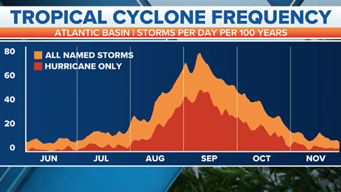
Tropical cyclone frequency chart from June 1 – November 30.
(FOX Weather)


