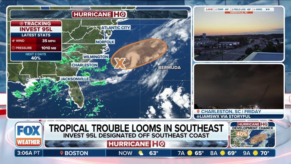
WILMINGTON, N.C. – The National Hurricane Center (NHC) has designated an area of disturbed weather off the Southeast and mid-Atlantic coasts as Invest 95L, and forecasters say there is a chance it could strengthen into Tropical Storm Dexter on Sunday or Monday.
The NHC said Invest 95L is located along a frontal boundary about 180 miles off the coast of North Carolina and is currently producing disorganized showers and thunderstorms.

Warning boxes are color coded as: Severe Thunderstorm Warnings in yellow, Tornado Warnings in red, Tornado Warnings with confirmed tornado in purple, Flash Flood Warnings in green, and Flash Flood Emergencies in pink.
(FOX Weather)
The term “invest” is a naming convention used by the NHC to identify a system that forecasters are investigating for possible development into a tropical depression or tropical storm within the next seven days.
“Environmental conditions are marginally conducive for this system to become a tropical or subtropical depression or storm today (Sunday) or on Monday while it moves east-northeastward at about 10 mph, away from the coast of North Carolina,” the NHC said in its latest tropical weather outlook.
Conditions will become less conducive for development after Monday.
DOWNLOAD THE FREE FOX WEATHER APP

(FOX Weather)
Currently, the NHC is giving Invest 95L a 50-50 chance of developing into a tropical system over the next two days.
If Invest 95L strengthens into a tropical storm, it would be named Dexter.
Flood alerts issued in Southeast as region faces threats of torrential rain, thunderstorms
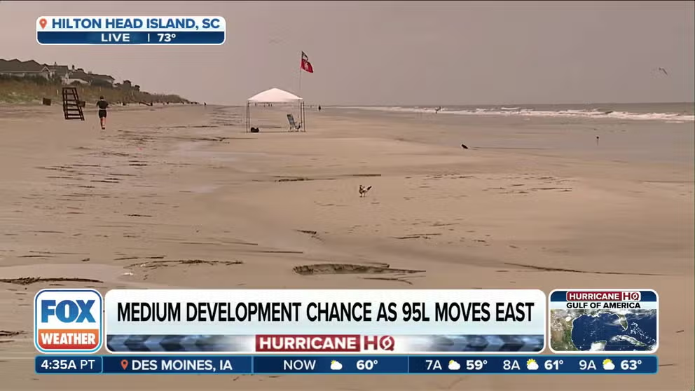
A stalled front over the mid-Atlantic and Southeast could lead to tropical development, with Invest 95L being designated off the coast. Regardless of development, the region is bracing for rounds of flooding rain and thunderstorms FOX Weather Meteorologist Bayne Froney was in Hilton Head with the latest on Aug. 3, 2025.
A powerful cold front is making itself at home in the Deep South and Southeast this week, and it’s bringing a forecast full of rainy days and an increasing risk of flooding along for the ride.
Regardless of tropical development for Invest 95L, some cities in Georgia, Alabama, South Carolina and northern Florida have a threat of showers and thunderstorms every day in the week ahead.

(FOX Weather)
The cold front and its rounds of heavy rain and storms will continue to sink to the south and east on Sunday. And while the morning should be quiet, storms will quickly develop during the afternoon hours in an arc around the edge of the cold front.

(FOX Weather)
That setup will allow the Lowcountry of South Carolina, South Georgia and most of Alabama to see the bulk of the activity.
As the new workweek begins, the forecast will remain the same – wet.
An upper-level disturbance that’s expected to slide into the region from the east will essentially stall across the Deep South.

(FOX Weather)
That will set up a consistent feed of moisture out of the Gulf and increase the lift needed for thunderstorms to develop and tap into that moisture.
Days of thunderstorms will drench the Southeast, particularly in Georgia and the western Carolinas.
Details are still being ironed out, but there will be a risk of flooding, and that will increase as the week continues.
New area to watch for tropical development in Atlantic

The NHC said a tropical wave is expected to move off the coast of Africa in the next day or two, and environmental conditions could support some gradual tropical development during the middle to end of the week ahead as it moves west-northwestward across the central tropical Atlantic Ocean.
Currently, the NHC is giving the system a low chance of developing over the next seven days.


