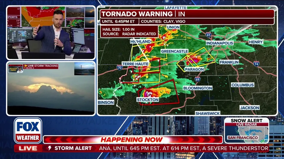
OHIO VALLEY —Confirmed large and dangerous tornadoes were spotted in East Central Illinois and Indiana on Thursday as severe weather impacts the Ohio Valley.
One of the tornadoes was reported just outside Bloomington, IN, on Thursday night, adding to the already disruptive evening.
The National Weather Service (NWS) reported receiving multiple accounts of structural damage and people trapped inside a mobile home linked to an earlier storm that brought hail and strong wind gusts.
Officials are still determining the ongoing damage throughout the region.
The NWS issued Tornado Watches for Indianapolis as well as several counties in Indiana, Kentucky and Illinois.
Tornado Warnings are in effect for Clark County, IL, Crawford County, IL, Green County, IN and Sullivan County, IN.
Other portions of Illinois and Indiana were also under Tornado Warnings.
WHAT IS THE DIFFERENCE BETWEEN A TORNADO WATCH, TORNADO WARNING AND TORNADO EMERGENCY?
The Storm Prediction Center (SPC) issued a level 3 out of 5 severe storm threat for portions of Illinois and Indiana. This is the first Level 3 threat in nearly five months, as well as the highest severe storm threat in 2026 thus far.
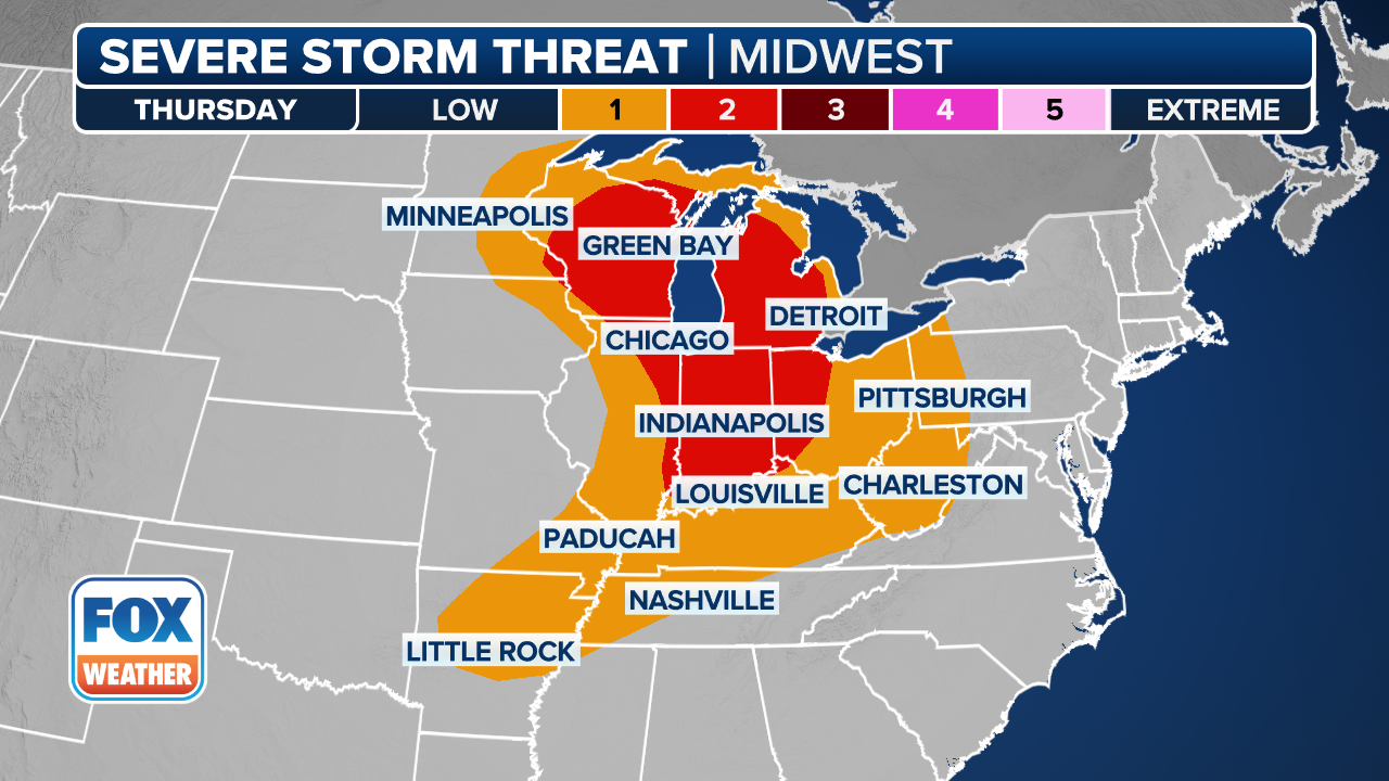
(FOX Weather)
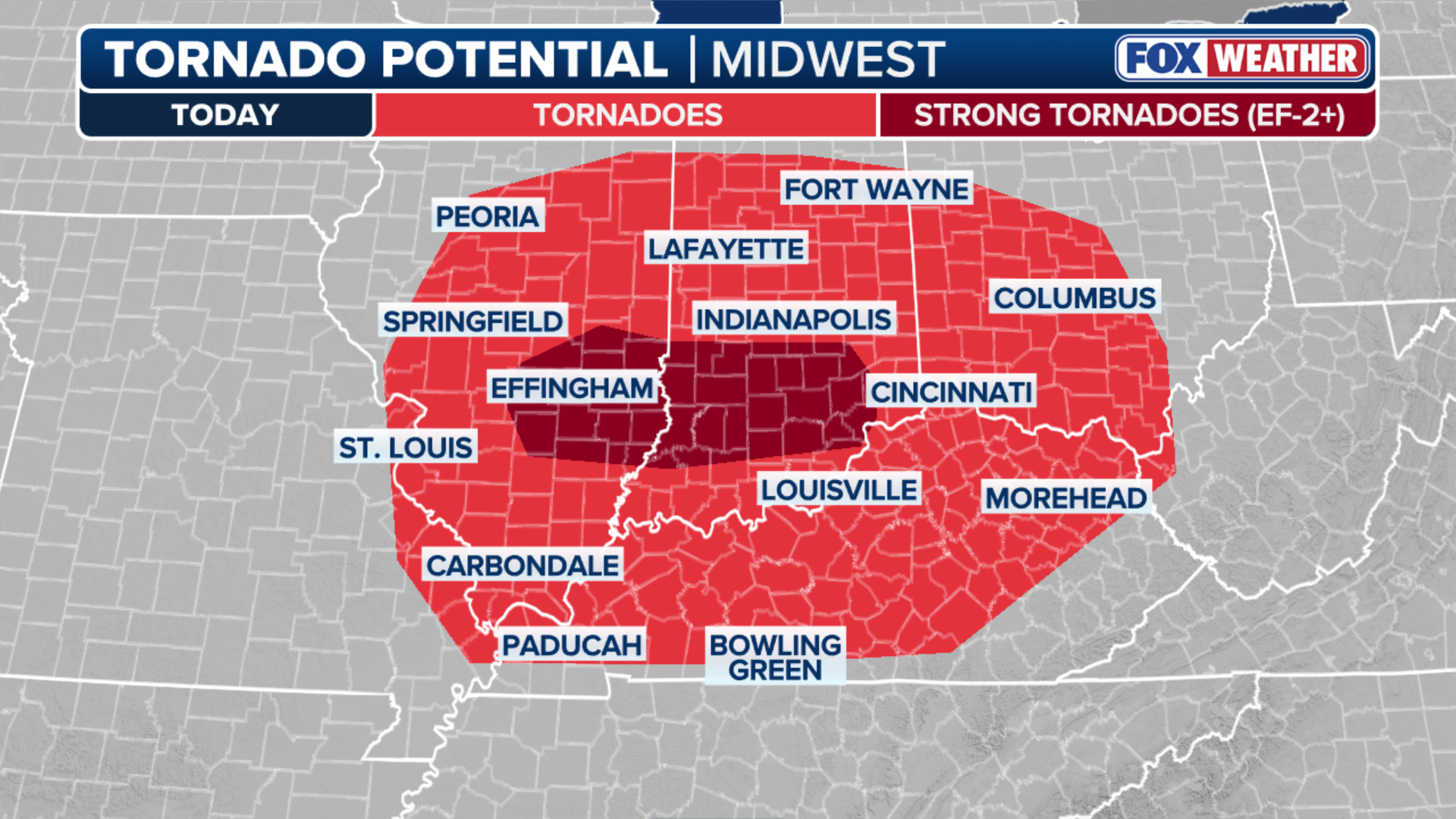
The SPC said that any tornadoes that formed could reach EF-2 or stronger.
OHIO VALLEY UNDER SEVERE STORM THREAT AS ACTIVE WEEK OF WEATHER IN THE MIDWEST UNFOLDS
According to FOX Forecast Center, strong wind shear combined with sufficient atmospheric lift could support the development of significant thunderstorms.

(FOX Weather)
The National Weather Service said that long-lived, multi-hour supercells were possible, which could support the risk of strong tornadoes.
Initial activity developed around midday across eastern Missouri and southern Illinois.
The FOX Forecast Center said these storms elevated the risk of hail up to the size of a quarter of 1 inch.
(FOX Weather)
As of mid-afternoon, a line of discrete thunderstorms formed across far eastern Missouri and southern Illinois, moving rapidly eastward.
As the day progressed, the tornado risk rose as these storms interacted with the warm front, taking advantage of enhanced low-level wind shear and a narrow zone of surface-based instability.
The evening transition thunderstorm activity eventually grew upscale into an organized line, shifting the primary concern toward damaging wind gusts.
These storms weakened after dark as they moved into the mid-to-upper Ohio Valley and encountered a more stable environment.


