
The U.S. Army Corps of Engineers has begun the estimated year-long process of removing ash and debris of homes and other structures destroyed in the Eaton and Palisades fires. One of the main questions from this process will be where and how will the debris be transported.
As of Friday, three haul routes had been defined for the Pasadena/Altadena area, according to the city of Pasadena
— West of Lake Avenue: Woodbury Road to Arroyo Boulevard to the 210 Freeway on/off ramps;
— East of Lake Avenue and west of Eaton Canyon Golf Course: New York Drive to Sierra Madre Villa Avenue to Rosemead Boulevard to the 210 Freeway on/off ramps; and
— East of Eaton Canyon Golf Course: Michillinda Avenue to the 210 Freeway on/off ramps.
Pasadena spokesperson Lisa Derderian said trucks will use other nearby streets until they reach the designated haul route and then will use the route to get to the freeway. The haul routes will not use Fair Oaks Avenue, Los Robles Avenue or Lake Avenue to the 210 on/off ramps, she said.

“A significant amount of truck traffic will be utilizing these haul routes, and signal timing will be adjusted to accommodate the additional traffic,” Derderian said in an email. “The city reminds Pasadena residents to be patient and drive safely if they experience the additional truck traffic along these haul routes, as this is a critical part of the rebuilding process and recovery effort.”
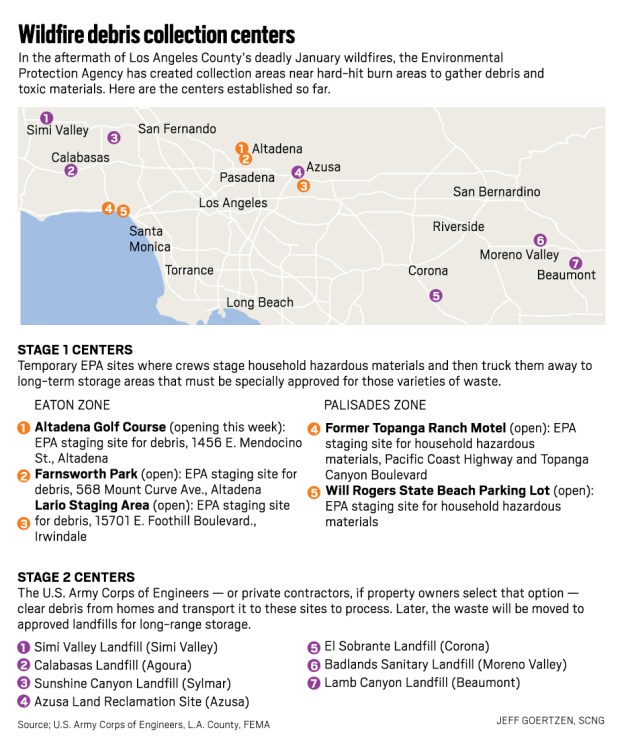
Col. Eric Swenson, who is leading the mission for the Army Corps, said that it is anticipated that there will be approximately 4.5 million tons of combined debris removed from the two fire footprints.
Swenson, who also led debris removal efforts in the wake of the 2023 Maui fire, said that disaster resulted in approximately 410,000 tons of debris.
He acknowledged in an interview with this news organization that one of the biggest challenges facing his crews will be L.A.’s infamous traffic.
“Because all of this fire ash and debris, the green waste, the concrete … all of that has to get out of these neighborhoods and to a proper disposal location,” Swenson said. “Which means we’re gonna be on the roads. That is going to be a challenge.”
During a news conference this week in Altadena, Gov. Gavin Newsom said there are a lot of logistics involved in hauling debris from burn zones and that new strategies are being looked at to address the congestion issue.
“We’re looking at dedicated lanes, we’re looking at strategies to stress test these landfills and I mean by stress testing that’s about ingress and egress into landfills,” Newsom said. “It’s not just the availability which we have for this debris to go into a landfill but it’s the ability to get the scales, the weights done and to make sure you’ve got the ramps so that we keep these operations flowing consistently.”
According to Caltrans, the following L.A. County highways are expected to be used for Eaton fire debris: the 5, 57, 71, 118 and 210 freeways.
Eaton fire debris is expected to be taken to landfills in Azusa, Simi Valley and El Sobrante as well as SA Recycling in Irwindale.
Palisades fire debris is expected to be hauled on the 1, 5, 10, 23, 27, 60, 118, 210 and 605 freeways, according to Caltrans. The debris is expected to be taken to the same three landfills as well as Sunshine and Calabasas. Recycling will go to SA Recycling locations in Irwindale, El Monte and Anaheim.

Caltrans said it does not anticipate having to close Pacific Coast Highway during the debris removal process. The implementation of dedicated lanes on PCH is being considered and would be in addition to the general purposes lanes made available once PCH reopens after mudslides.
“A final determination of the traffic control to facilitate the debris removal will be made upon further engagement next week,” Caltrans said in a statement.
Lane closures associated with debris removal will be posted on the Caltrans QuickMap.
Malibu spokesperson Matt Myerhoff said Thursday that the Army Corps had not yet told the city what the routes will be.
“Last we heard from them, they did not know yet where the debris was going, much less the route,” Myerhoff said in an email.
At Wednesday’s Calabasas City Council meeting, the council voted to approve multiple motions opposing the Calabasas Landfill being used to for Phase-2 debris removal.
Residents including Natasha Downing are holding a protest Saturday, Feb. 15, opposing the use of the landfill which Downing said is near her home and several schools. Downing planned to live in Calabasas the rest of her life, but concerns about debris being hauled to Calabasas has made her uncertain about the future.
“If my options are stay in a place where I love where my children have a high risk of getting very, very sick or leaving to somewhere that I don’t love, I’m going to pick my children’s health,” Downing said.
City officials noted during the meeting that the landfill is owned by L.A. County and not the city. In addition, the landfill accepted about 200,000 tons of fire debris from the 2018 Woolsey fire.
According to the city, some the roads being considered for hauling debris to the landfill include Malibu Canyon, Lost Hills Road, Las Virgenes Road and Agoura Road.
“All of these places where they’re sending debris, it should not be happening. These are where people live,” Downing said. “This debris shouldn’t be anywhere near humans. Los Angelenos have suffered enough and they don’t need to poison us as well.”
South Coast Air Quality Management District said it is integrated with debris removal task force and in communication with the EPA and Army Corps. The Army Corps has not requested air monitoring of truck routes from AQMD.

AQMD conducted air monitoring in and around the burn areas of both fires and will be setting up stationary monitors. Results of the initial surveys in the Eaton and Palisades fire areas found Volatile Organic Compounds and air toxins to be within the normal levels of a typical day and below the national and state health thresholds.
A second survey in both fire areas will be done next week, AQMD said.
The California Highway Patrol reminded drivers to stay vigilant in construction zones and to plan ahead, giving themselves more time to travel and checking for road closures before starting a drive.
Residents can access information from CHP on social media and can call 1-800-427-7623 for current road conditions.


