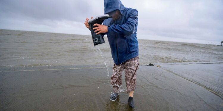
MORGAN CITY, La. (AP) — Hurricane Francine struck the Louisiana coast Wednesday evening as a dangerous Category 2 storm that rapidly knocked out electricity to more than 100,000 customers and threatened widespread flooding as it sent potentially deadly storm surge rushing inland along the northern U.S. Gulf Coast.
Francine made landfall in Terrebonne Parish, about 30 miles (50 kilometers) southwest of Morgan City, the National Hurricane Center announced at 4 p.m. CDT. Packing maximum sustained winds near 100 mph (155 kph), the hurricane crashed into a fragile coastal region that hasn’t fully recovered from a series of devastating hurricanes in 2020 and 2021.
Morgan City Fire Chief Alvin Cockerham said the hurricane’s arrival quickly flooded streets, snapped power lines and sent tree limbs crashing down.
“It’s a little bit worse than what I expected to be honest with you,” Cockerham said. “I pulled all my trucks back to the station; it’s too dangerous to be out there in this.”
TV news broadcasts from Louisiana’s coastal communities showed waves from nearby lakes, rivers and Gulf waters thrashing sea walls. Water poured into city streets and neighborhoods amid blinding downpours. Oak and cypress trees leaned in the wind, and some utility poles swayed back and forth.
Power outages in Louisiana exceeded 109,000, spreading across a wide area of southeast Louisiana. Hardest hit by the blackouts was Terrebonne Parish near where the storm’s center hit land, as well as neighboring St. Mary Parish that includes Morgan City.
The National Hurricane Center urged south Louisiana resident to take shelter for the night as the hurricane moved to the northeast at 17 mph (28 kph). That included New Orleans, where forecasters said the storm’s eye could pass through.
“Conditions are going to go downhill really rapidly over the next couple of hours,” Jamie Rhome, the hurricane center’s deputy director, said in an online briefing just before landfall. “It’s not going to be a good night to be driving on the roads, especially when the sun goes down.”
Francine drew fuel from exceedingly warm Gulf of Mexico waters, strengthening from a Category 1 to a Category 2 storm hours before landfall, the National Hurricane Center said. Category 2 hurricanes are classified as having winds of between 96 to 110 mph (155 to 175 kph) that are capable of extensive damage.
Louisiana Gov. Jeff Landry also urged residents to “stay off the roads, stay home and stay put.” He said the National Guard would fan out to parishes impacted by Francine. They have food, water, nearly 400 high-water vehicles, about 100 boats and 50 helicopters to respond to the storm, including for possible search-and-rescue operations.
Since the mid-19th century, some 57 hurricanes have tracked over or made landfall in Louisiana, according to The Weather Channel. Among them are some of the strongest, costliest and deadliest storms in U.S. history.
Morgan City, home to around 11,500 people, sits on the banks of the Atchafalaya River in south Louisiana and is surrounded by lakes and marsh. It’s described on the city’s website as “gateway to the Gulf of Mexico for the shrimping and oilfield industries.”
Gas stations had put plywood on the windows and moved trash cans inside. A few pumps had served a trickle of cars passing through earlier Wednesday, hours before Francine made landfall.
Retired boat captain Pat Simon, 75, and his wife loaded their possessions in garbage bags and tied them down in the back of a rented U-Haul pickup truck as they evacuated their home near the banks of the Atchafalaya River near Morgan City.
“I don’t think it’s going to be that bad, like some of the other ones like Ida and Katrina,” Simon said. “I mean, we’ve had some bad ones.”
President Joe Biden granted an emergency declaration to help Louisiana secure expedited federal money and assistance. Landry and Mississippi Gov. Tate Reeves also declared states of emergency, authorizing them to quickly free up resources for disaster assistance.
A hurricane warning was in effect along the Louisiana coast from Cameron east to Grand Isle, about 50 miles (80 kilometers) south of New Orleans, according to the Miami-based hurricane center. A storm surge warning stretched from the Mississippi-Alabama border to the Alabama-Florida border.
The Mississippi Emergency Management Agency said it distributed more than 100,000 sandbags to the southern part of the state and the Department of Education reported a number of school district closures for Wednesday and Thursday.
Bands of heavy rain began pelting New Orleans on Wednesday morning. The city’s historic streetcars that roll on South Carrollton Avenue had to ease past cars parked next to the tracks on a grassy median where their owners hoped to avoid street flooding.
Francine became the sixth named storm of the Atlantic hurricane season. Much of Louisiana and Mississippi could get 4 to 8 inches (10 to 20 centimeters) of rain, with the possibility of 12 inches (30 centimeters) in some spots, said Brad Reinhart, a senior hurricane specialist at the hurricane center.
Francine’s storm surge on the Louisiana coast was forecast to reach as much as 10 feet (3 meters) from Cameron to Port Fourchon and into Vermilion Bay, forecasters said, adding tornado watches also have been posted over a large area of south Louisiana and neighboring Mississippi as the storm heads inland.
The hurricane center said parts of Mississippi, Alabama and the Florida Panhandle were at risk of considerable flash and urban flooding in coming. The lower Mississippi Valley and lower Tennessee Valley could experience flooding later in the week as the disbanding storm’s considerable remnants sweep northward across several states in coming days.
___
Cline reported from Baton Rouge, Louisiana. Associated Press writers Kevin ll in New Orleans, Curt Anderson in St. Petersburg, Florida, and Russ Bynum in Savannah, Georgia, contributed to this story.


