HOUSTON – After flooding caused wreckage across the Texas Hill Country, NASA’s Disaster Program resources were brought in to provide crucial data to aid in the massive ongoing search for more than 170 missing people as first responders sort through catastrophic amounts of debris.
On the ground in Kerr County, Texas, first responders have searched 26 miles of the Guadalupe River after the July Fourth weekend flooding. Meanwhile, NASA aircraft have been providing eyes in the sky to local, federal and nonprofit groups.
BEFORE-AND-AFTER SATELLITE PHOTOS OF CAMP MYSTIC, KERR COUNTY SHOW DEVASTATION OF TEXAS FLOODS
Shanna McClain, the Disasters Program Manager for NASA’s Earth Sciences Division, said that when disaster strikes, her team works to meet the needs of those on the ground. This week, NASA data is helping the Texas Division of Emergency Management, the Federal Emergency Management Agency (FEMA) and nonprofit groups – Save the Children and GiveDirectly. However, like all NASA data, it’s available to anyone who can use it.
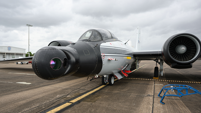
The high-altitude WB-57 aircraft departed July 8, 2025, from Ellington Field in Houston, Texas, headed to the Texas Hill Country. The aircraft used the DyNAMITE (Day/Night Airborne Motion Imager for Terrestrial Environments) sensor system to take video mosaics of the area to assist with the emergency response effort.
(NASA)
“We try to understand what our partners’ needs are and figure out, working backwards, how to translate the science into supporting them effectively,” McClain told FOX Weather.
Because cloud cover blocked some NASA and partner satellite views of Texas, McClain said they opted to utilize assets that could look below the clouds and provide situational awareness of the flooding area.
WHAT’S BEHIND ALL THE RECENT EXTREME FLOODING?
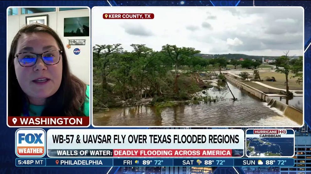
Earlier this week, NASA’s WB-57 aircraft took off from Ellington Field at NASA’s Johnson Space Center in Houston using the DyNAMITE (Day/Night Airborne Motion Imager for Terrestrial Environments) sensor to determine where flooding remained and if large debris piles had shifted.
The WB-57 flies at between 15,000 and 20,000 feet, much lower than satellites.
“So this is the first look of the two river basins where we’re seeing the largest flooding extents,” McClain said. “And ideally, it helps with a range of planning decisions, right? Evacuation routes, ingress/egress for first responders, and other organizations.”
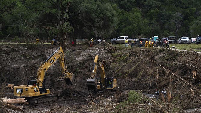
Recovery crews work along the Guadalupe River following the flood in Hunt, Texas, US, on Wednesday, July 9, 2025. Crews in central Texas are digging through massive piles of debris, overturned vehicles and shattered homes for a sixth day as the search continues for victims of flash floods that killed more than 100 people over the Fourth of July weekend.
(Eli Hartman/Bloomberg via Getty Images / Getty Images)
Meanwhile, NASA’s Gulfstream III departed from the Armstrong Flight Research Center in California using a vegetation-penetrating radar known as UAVSAR (Uninhabited Aerial Vehicle Synthetic Aperture Radar) to take observations over the Guadalupe, San Gabriel and Colorado river basins. The Gulfstream III will make additional trips through Friday, according to NASA.
“We knew that flying these two in harmony would help us give our partners on the ground a better understanding of how much flooding and where the flooding was taking place,” McClain said.
Debris slows search, but no solution yet
In the Texas Hill Country, the greatest problem for searchers has been the amount of debris. This is not a new problem for the disaster management community.
“The debris problem is a long-standing and unanswered question,” McClain said.
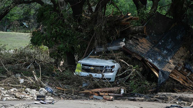
A view of destruction after heavy rainfall overwhelmed the Guadalupe River, sending floodwaters roaring through homes and area summer camps in Hunt, Texas, United States on July 8, 2025.
(Lokman Vural Elibol/Anadolu / Getty Images)
The large amount of debris left by flooding in Texas, and from other disasters, such as Hurricane Helene last year in North Carolina, makes finding victims extremely difficult, and the removal process tedious. Following the extensive debris caused across multiple states last year from hurricanes Helene and Milton, NASA and other partners began working on a new approach to tackle this problem – but it is still a work in progress.
“We’re essentially looking at the use of commercial satellite imagery along with assets like UAVSAR and others to see if we can create a very truthful and scientifically correct approach at assessing it,” McClain said. “We’re not there today.”
With lessons learned from Helene, McClain said the NASA Disaster Program team has worked on being ready to help faster, which requires practice during “blue sky times.”
“I think being able to deploy the science and the airborne assets faster is critical,” McClain said. “We need the trust to be high. We needed to be accurate so that we’re not giving bad information. All of this takes training and, I think, setup, you know, that we do during blue sky time so that we are there and able to help everyone during times like this.”
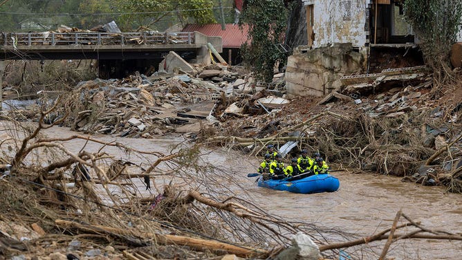
A rescue team paddles down the Swannanoa River on Sunday, Sept. 29, 2024.
(Travis Long/The News & Observer/Tribune News Service / Getty Images)
Additionally, the information collected during disaster response could also help communities prevent them.
“We put a lot of energy in disaster risk reduction, disaster mitigation and also on recovering, so that communities like this can ideally, at some point in time, start to recover without worrying about the threat of the next flood, right, or the next event that may happen in their area,” McClain said.
NASA data will likely be part of the conversation in Texas as officials in Kerr County and Texas Gov. Greg Abbott promised a full review of the flooding response and the lack of warning systems along the river.


