Exhibits are made to be movable at the waterside Annapolis Maritime Museum. Some are on wheels and most can be elevated for instances when a flood at the end of Eastport’s Second Street is imminent — that situation has occurred three times within the past three years.
“We have learned to roll with it,” Alice Estrada, the CEO of the museum from 2013 through September of this year, said. “That was something that in the past was more crippling, but now we have learned a routine to anticipate these, what’s becoming more and more frequent, serious floods.”
As the Chesapeake Bay rises along with the world’s oceans, the city of Annapolis and other local partners are looking for ways to protect the low-lying city neighborhoods from ruin.
Annapolis broke ground in November on the two-year, $87 million City Dock project, aimed to protect frequently flooded downtown businesses from sea level rise and expected flood events through 2060.
The Eastport peninsula is the other of the two lowest-lying areas of the city, and is one of the sites targeted by the city’s efforts to reduce the impact of water level rise. That phenomenon threatens to further damage buildings, and possibly homes, in communities along the Chesapeake Bay, by increasing the frequency of nuisance flooding and worsening the impact of major storms.
Global sea levels rose 8 to 9 inches from 1880 to 2023, largely due to climate change, according to the National Oceanic and Atmospheric Administration. The bay rose half a foot within the past 25 years, according to William Sweet, an oceanographer at NOAA.
Sea level is expected to rise by about an additional foot before 2050, according to an intermediate sea level rise prediction from NOAA, but could rise 1.74 feet above 2000 levels by 2050 in a worst-case scenario.
The sea levels in Annapolis are rising about 3.87 millimeters per year, according to NOAA. Last year had the highest number of flooding events in Annapolis history since at least 1900, according to NOAA records, with 25 flood days in the city.
The higher water levels increase the frequency of water pushed by winds up the Chesapeake Bay, causing flooding in low areas of the city, often called nuisance flooding, Sweet said.
The land Annapolis sits upon is also sinking, according to Sweet. The Chesapeake region, he said, is sinking due to the pumping of groundwater to drink and natural sediments adjusting in response to the last Ice Age.
“What’s getting wet now is going to be getting a lot more wet more frequently,” Sweet said. “Areas that are currently dry are going to start getting wet.”
Eastport peninsula’s flooding presents a different challenge from the City Dock, which is on city property. Much of the flooding is concentrated in pockets around private properties, including some of the highest-valued homes in the city. The flooding tends to gather on the streets, between Second Street and Fifth Street, and has not yet significantly entered homes or businesses.
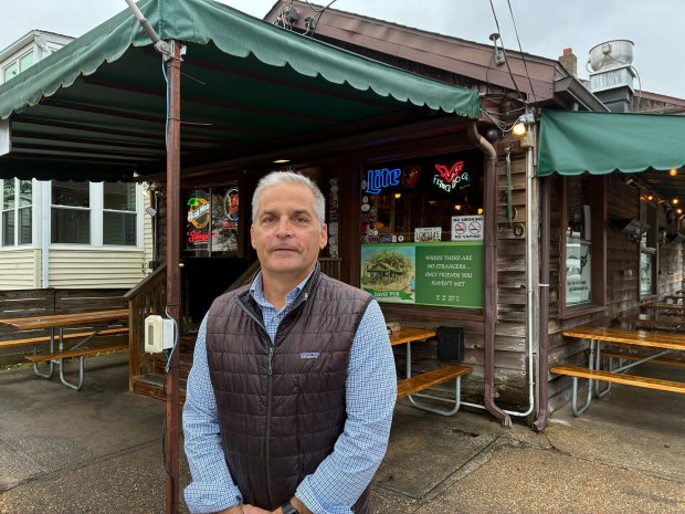
Kevin Colbeck, the 30-year owner of Davis’ Pub in Eastport, is one of the few businesses in a flood-prone area at the corner of Fourth Street and Chester Avenue. He said he’s lucky that the pub has a raised floor, which has prevented his business from experiencing the flood impacts felt by the businesses at City Dock, with the exception of the 2003 flooding from Hurricane Isabel.
About 15 to 20 times per year, Colbeck said, the streets around his pub flood, mostly due to storm drains backflowing from the nearby water into the street. When he hears that there might be a flooding event, Colbeck said he might move his outdoor tables and encourage his customers to move their cars.
“We’ll just take it as it comes; hopefully there’s a smart plan and decision to help kind of preserve this corner of the world, and not only the businesses but the neighbors,” Colbeck said. “Hopefully through some smart decisions worldwide on climate change and locally … we can buy some time so we figure out a better solution.”
Tori Tomiczek, an associate professor in the Naval Academy’s ocean engineering department, has been measuring the water levels in storm drains near Davis’ Pub for about two years. From August through October, the drains, which can backflow into the street outside the pub, were flooded about 9.1% of the time, she said.
The city government has taken steps to begin work to address flooding in Eastport along with state, federal and local partners. In the fiscal 2026 budget, the City Council approved funding to start the design process for stormwater improvements to prevent water backflowing into the ends of streets in Eastport. The funding is set to go toward planning flood prevention upgrades near the Maritime Museum and a pump station.
The total project, once construction is completed, is budgeted to extend through fiscal year 2029 and cost $5.8 million.
Other flood prevention projects are in planning stages and in the works throughout the city, city spokesperson Mitchelle Stephenson said, and some have been completed in Eastport such as the installation of a living shoreline near the Maritime Museum by the Maryland Department of Natural Resources.
The Resilience Authority of Annapolis and Anne Arundel County is finishing planning and design work, funded by the National Fish and Wildlife Foundation, to improve flood mitigation infrastructure in Eastport and surrounding areas through its Annapolis Maritime Resilience Initiative.

Gabe Cohee, the programs director for the resilience authority, said the group’s work is focusing on ways to harness nature to minimize the impacts of sea level rise and flooding such as shoreline work and rain gardens.
To protect against the more frequent flooding, Tomiczek said the city should continue its current work to prevent the stormwater system from increasing the chances of floods, such as installing valves and pumps. Longer term, she said there may need to be talks about adding walls or other barriers to block water, or raising homes in flood-prone areas.
“The solutions that we have right now are just buying us time,” Tomiczek said. “At some point we’re going to have to really think about some really grand-scale solutions or decisions that are going to take a lot of buy in, whether that’s because it’s a big project or because it’s going to require some changes in the community.”
Former longtime Ward 8 Alderman Ross Arnett, whose term ended Dec. 1, said the city’s response to Eastport flooding is a difficult cost-benefit question due to the requirement to preserve “community character,” ensuring that roads are drivable, and preserving the housing stock long-term. With the most “immediate threat,” being addressed with the City Dock Project underway, Arnett said flood mitigation in Eastport needs to be a focus of the new City Council.
He said the situation is only going to get worse if nothing significant is done, at a local level and at an international level to address the warming climate.
“This is not an Annapolis problem or a Ward 8 problem. This is a country-wide problem,” Arnett said.
Have a news tip? Contact Katharine Wilson at [email protected].

