FOX Weather is your Hurricane HQ.
(FOX Weather)
Updated at 8:45 a.m. ET on Tuesday, Oct. 21, 2025
The tropical disturbance we’ve been tracking – officially Invest 98L – is on the cusp of becoming Tropical Storm Melissa. The system already has sufficient winds, about 45 mph, and it’s finally showing signs of a closed circulation.
Hostile upper-level winds are still pushing dry air into the system and tilting the vortex toward the east, but they have let up enough for the circulation to establish itself. The system has slowed its forward speed, which is also helping it stand up straight. The closed circulation is required for a system to be designated a tropical storm because a system can’t intensify without accomplishing that step first.
The atmospheric pattern ahead is forecast to soon become supportive of further development. The big question is how supportive?
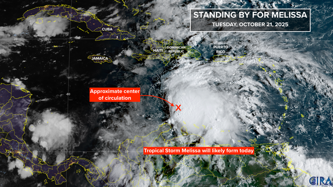
This satellite image shows Invest 98L in the Caribbean on Oct. 21, 2025.
(FOX Weather)
In general, computer forecasts that intensify the system rapidly turn it almost immediately to the north over Hispaniola – the island containing Haiti and the Dominican Republic. Meanwhile, models that develop it more slowly drift it farther west in the Caribbean. In that case, the system could sit over the extremely warm Caribbean waters for a week or more.
A dip in the jet stream offshore of the U.S. East Coast will be ready to scoop Melissa north tomorrow or Thursday, but it will only be able to grab it if the storm has developed and is reasonably strong. Otherwise, the dip is likely to be on its way, and Melissa will be left with no significant steering mechanism.
If the storm remains in the Caribbean, it looks to be stuck there for some time. The farther west it drifts, the more heat content there is in the water. A very strong hurricane is possible.
A strong dip in the jet stream is in the long-range forecasts for next week. Depending on where Melissa is and how intense it’s become, that dip could scoop it north over Cuba.
The consensus of the various computer forecasts is that possibly Hurricane Melissa will stall and maybe loop south of Haiti and east of Jamaica into next week, when it will get scooped north over Cuba, but that’s far from set in stone.
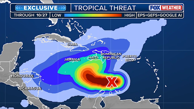
This graphic shows the exclusive FOX Weather Tropical Threat analysis.
(FOX Weather)
The exclusive FOX Weather Tropical Threat analysis covering until next Monday shows that there is high confidence that Melissa will track into the waters south of Haiti and Jamaica, but then the odds of any one path decrease dramatically. The possibility of a quick turn over the Dominican Republic is indicated by the bulge in that direction. But the idea of a stall between Jamaica and Central America is also shown by the green bulging that way.
If Melissa doesn’t turn into that Dominican Republic bulge, it will likely be around well into next week.
There is no indication of a threat to the mainland U.S. There are strong west-to-east winds over the Gulf, which should prevent any systems from sneaking up from the south.
In the short term, residents in Haiti and the Dominican Republic should stay informed and be ready for extreme and dangerous rainfall, at the least. Puerto Rico should keep an eye on it just in case there are fringe effects.
Jamaica could also be in Melissa’s path. And, of course, Cuba and the southern half of the Bahamas might be affected next week, but it’s too soon to know.
Slow-moving tropical storms or hurricanes are extremely dangerous, especially over mountainous islands. Feet of rain are not out of the question, depending on Melissa’s exact path.


