Updated at 9:30 a.m. ET on Tuesday, Aug. 19, 2025
We have a special LIVE streaming Hurricane HQ&A this afternoon at 4 p.m. ET. NHC Deputy Director and Storm Surge Expert Jamie Rhome will join me to take your questions about the expected impacts from Hurricane Erin and any other questions you have.
We’ll be live on Facebook, YouTube, TikTok, X, Instagram and LinkedIn. Hope to see you then.

Join FOX Weather Hurricane Specialist Bryan Norcross for a special Hurricane HQ&A on Tuesday, Aug. 19, 2025.
(FOX Weather)
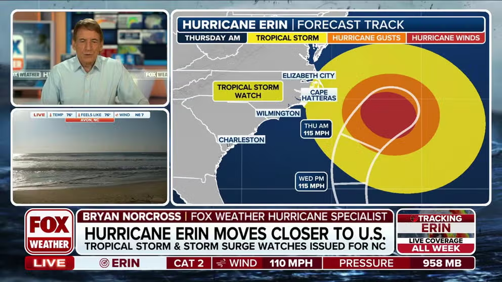
Hurricane Erin is slowly pulling away from the Bahamas and dramatically growing in size. The top winds have weakened to Category 2 – but the increase in the diameter of the system more than makes up for the decrease in wind speed in terms of the amount of energy that the storm puts into the ocean water.
Already, the rip current risk is high along most of the U.S. East Coast, and the effects from the storm have only barely begun – there has already been a series of rescues at the beach in North Carolina.
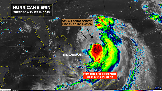
This image shows details on Hurricane Erin on Aug. 19, 2025.
(FOX Weather)
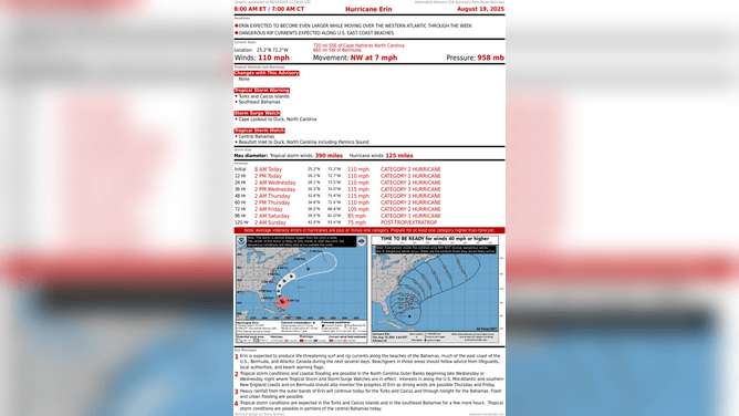
The National Hurricane Center has issued a Tropical Storm Watch for eastern North Carolina because Erin’s expanding circulation could brush the tip of the state. The watch means that sustained winds of 40 mph or higher with gusts to 50 to 60 mph are POSSIBLE. Stay aware of updates to the wind forecast.
In addition, a Storm Surge Watch was issued, indicating the possibility that the ocean water will rise over 3 feet above the normal high tide level. Specifically, the forecast for the Outer Banks and nearby areas is 4 feet above normal high tide. This will put significant pressure on the beaches and structures near the ocean.
Storm surge up to 3 feet above normal is forecast as far south as Myrtle Beach, South Carolina, and as far north as Norfolk and the Tidewater area of Virginia.
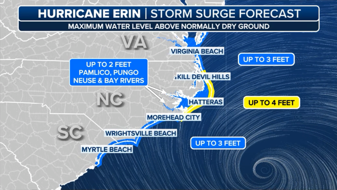
This graphic shows the storm surge forecast along the Carolina coast.
(FOX Weather)
Through the day today, strong swells radiating from the core of the hurricane will increasingly reach the Southeast coast – especially from Palm Beach County, Florida, to Cape Hatteras, North Carolina. Increasingly large and powerful waves will pound the shoreline for the next three days, scouring sand and overwashing low-lying areas. Strong ocean currents will add to the damaging scenario.
Extreme South Florida is mostly protected by the Bahamas, although some of the energy from the swells will reach the coastal waters around Miami and Fort Lauderdale. Watch for rip current alerts.
This graphic shows the forecast for Hurricane Erin.
(FOX Weather)
Late Wednesday and through Friday, the impacts will move north affecting the entire northern half of the East Coast, including the Tidewater in Virginia, the Delmarva Peninsula, the Jersey Shore, coastal Long Island, New England and Atlantic Canada.
Coastal vulnerability will peak at times of high tide. Energy from the storm will push the tides higher than normal and produce large, powerful waves on top of that.
Follow local instructions to stay safe. Even knee-level water in the ocean will be able to knock you over because of the extra strong currents.
There is high confidence that the core of the storm with the strongest winds will pass between North Carolina and Bermuda. Erin will be moving slowly the first half of this week and then accelerating out to sea Friday and Saturday. The net effect will be a long-duration event with increased energy affecting multiple high tide cycles.
2 more systems in the tropical Atlantic
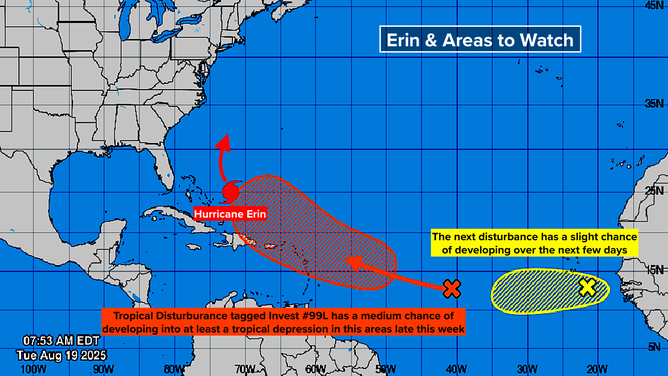
This graphic shows Hurricane Erin and other areas to watch for tropical development in the Atlantic Ocean.
(FOX Weather)
A large, disorganized tropical disturbance (tagged Invest 99L) is making its way across the tropical belt between Africa and the Caribbean. The system is forecast to reach the vicinity of the northeastern Caribbean islands Friday or Saturday. The National Hurricane Center is giving the disturbance a medium-high chance of developing into at least a tropical depression.
If winds within the circulation reach 40 mph or higher, it will be named Tropical Storm Fernand.
The consensus of the long-range computer forecasts is that the system, whether it is Fernand or not, will pass over or near Puerto Rico and the nearby islands before turning north. Another strong dip in the jet stream is forecast to come along to lift the system out of the tropics. It’s not clear how close it might come to the East Coast of the U.S.
This is far from set in stone, of course. Forecasts for disorganized disturbances are always subject to significant changes. For now, we stay aware that a tropical system is forecast to move into a location where we have to pay close attention to it this time of year.
There’s another disturbance closer to Africa that the National Hurricane Center is taking note of. They give it a low chance of developing at this point as it moves across the tropical Atlantic. The computer forecasts don’t do much with this one. They predict a lot of dry air and an upper-level wind regime that is not very conducive to development. But, of course, we’ll watch carefully.


