FOX Weather is your Hurricane HQ.
(FOX Weather)
Updated at 9:15 a.m. ET on Sunday, Aug. 24, 2025
When the sun came up over southern Dade County, Florida, on Aug. 24, 1992, the landscape was unrecognizable. I saw it for the first time on television from the live helicopter late that afternoon – along with everybody else who had power. That did not include South Dade, of course. The power there was out for three months.
Hurricane Andrew’s hellacious attack on South Dade lasted for less than three hours. Our modern understanding is that the peak sustained winds were 165 mph with gusts over 200 mph. But the numbers don’t tell the story.
Andrew was strengthening as it made landfall. Unlike most hurricanes whose winds fade quickly after the center crosses the coast, Andrew continued at close to full force. Over land, gusts increase because of the friction and turbulence caused by the interaction with trees, buildings and the ground itself. That lack of weakening, which produced even stronger gusts, is likely what accounts for the unbelievable and unimaginable events that occurred that Monday morning.
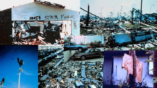
This image shows destruction caused by Hurricane Andrew in South Florida in August 1992.
(Bryan Norcross)
We don’t see palm trees impaled by flying plywood and two-by-fours, or cars flipped over in garages, or cars landing on top of one another in even the most damaging hurricanes. Andrew was stunning in every way that you can imagine.
Good things came out of Hurricane Andrew, of course. The building code in South Florida was dramatically hardened, so the structures built during the incredible building boom of the last 20 years have been built to the highest hurricane standards in the world.
Emergency management was reconstituted after Andrew because the state of Florida could not handle a disaster of that scale. Let’s hope modern planners are aware of that reality.
Long-time Miami people will never forget the events that took place that early morning 33 years ago. Modern-day residents and emergency planners study those events well. None of us want to experience anything like that again.
Tropical Storm Fernand forms
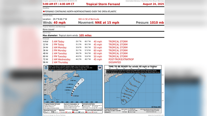
This graphic shows information on Tropical Storm Fernand.
(FOX Weather)
The disturbance that was called Invest 90L formed into Tropical Storm Fernand more or less on schedule. The storm is forecast to head north, staying east of Bermuda, well away from the U.S., and then arc out to sea. Bermuda might feel some fringe effects.
Approaching the Caribbean
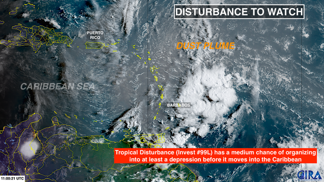
This satellite image shows Invest 99L approaching the Caribbean Sea on Aug. 24, 2025.
(FOX Weather)
The other system we’ve been following, Invest 99L, is heading for the Caribbean islands. There’s still a chance it could spin up into at least a tropical depression, but whether it does or not, the system will move through the islands as a gusty moisture surge. Heavy tropical downpours and gusty winds are likely over the next couple of days.
The system will move into the Caribbean by Tuesday where atmospheric conditions become hostile. And that should be that.
Looking ahead

(FOX Weather)
The general atmospheric pattern across the tropics is forecast to be somewhat hostile over the next two weeks or so. That doesn’t mean nothing will develop, but if something tries, it will have a harder time. For now, nothing new is in the offing.


