Updated at 9:30 a.m. ET on Wednesday, Sept. 10, 2025
Today at 4 p.m. ET, we hope you’ll tune in for the next Hurricane HQ&A LIVE on YouTube, Facebook, TikTok, X, Instagram and LinkedIn. We’ll talk about what’s going on in the tropics, and my special guest will be hurricane historian and author Jay Barnes. Jay is an expert on Florida and North Carolina hurricanes.
We’ll be looking forward to your questions. LIVE today at 4 p.m. ET.

Join FOX Weather Hurricane Specialist Bryan Norcross for a live Q&A on Sept. 10, 2025.
(FOX Weather)
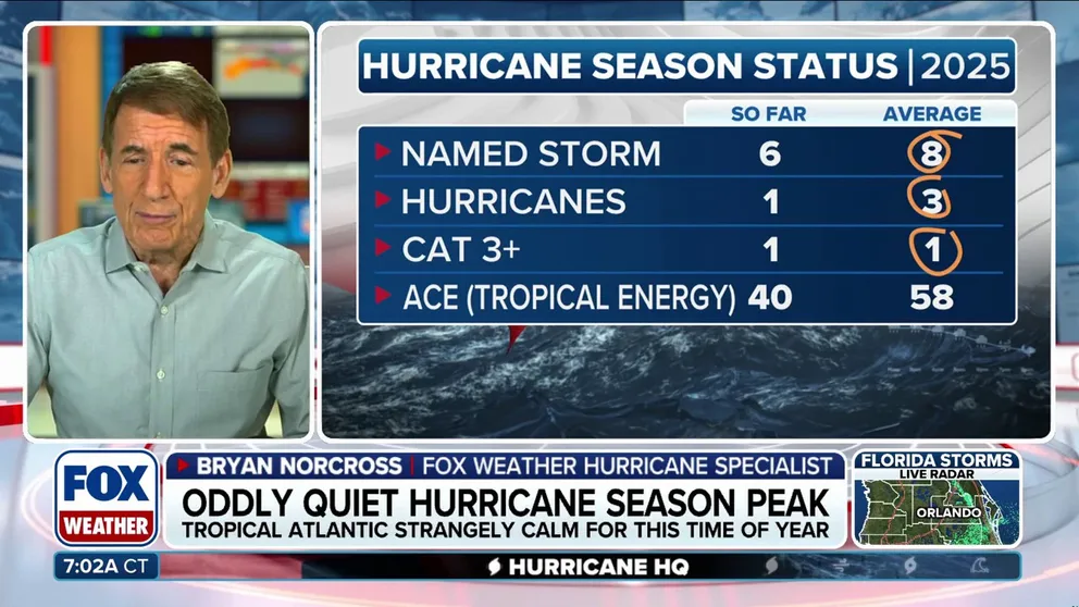
The peak of the season
Today is the date on the calendar when, historically speaking, we are most likely to have a named storm in the Atlantic, the Caribbean or the Gulf. The likelihood of an active hurricane peaks about now as well.
It’s extremely unusual to have an extended quiet period from the last days of August to the peak of the season and beyond. There’s only one example in the record book of that happening. In 1992, Mother Nature gave us a break for a few weeks after Hurricane Andrew hit South Florida. Tropical Storm Bonnie finally formed far out in the Atlantic on Sept. 18.
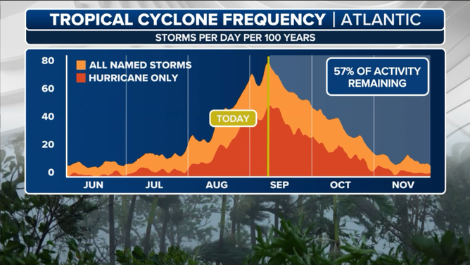
This graphic shows the tropical cyclone frequency.
(FOX Weather)
The current lull looks likely to last for at least another week and perhaps a little beyond. The indications that we have, however, show a weather pattern more conducive to tropical development around the third week of the month.
There’s no obvious single reason for the tropical pause, but there seems little doubt that it’s related to the excessively high pressure across the Atlantic. And that may well be connected to the unusually persistent jet stream dip that has been stuck over the eastern U.S. It’s that southern undulation in the jet stream that has brought the cool weather to the Midwest and East and the relentless waves of heavy rain over the Florida Peninsula.
There are also hints that the upper atmosphere might be warming faster than the air close to the ocean, which limits storm development.
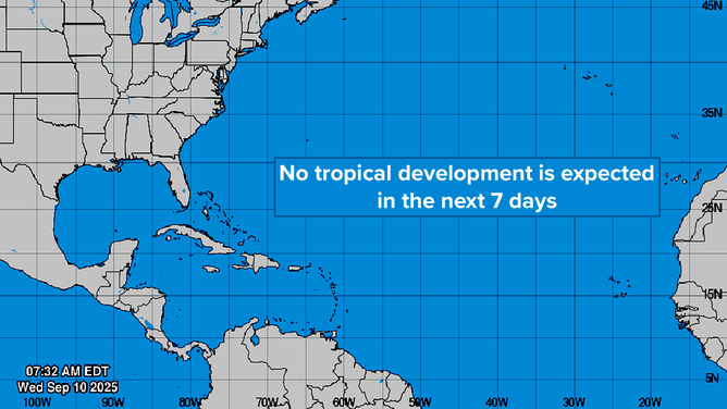
This graphic provides an overview of the tropical Atlantic Basin on Sept. 10, 2025.
(FOX Weather)
We had a similar unexpected stoppage during last year’s hurricane season, if you recall. The temperature profile was also unsupportive of development, but other factors were in play as well. But whatever the cause, the key takeaway from last year was that just because we stopped having storms for a few weeks doesn’t mean destructive storms can’t form in the second half of the season – as in Helene and Milton.
In the Pacific

This graphic shows the latest on Tropical Storm Kiko north of the Hawaiian Islands.
(FOX Weather)
Kiko is dying out as it’s passing north of Oahu and the western Hawaiian Islands. It will head off to die in the Central Pacific.
Another storm, which will be named Mario, is forecast to develop in the next couple of days offshore of southern Mexico. The system is likely to strengthen but not directly impact the Mexican coast.
65 years ago today
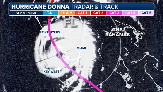
This satellite image shows Hurricane Donna.
(FOX Weather)
On Sept. 10, 1960, massive Category 4 Hurricane Donna mauled the middle Florida Keys as it moved from the Atlantic into the Gulf. Here it was, captured on the Miami radar after the eye had passed the Keys and was heading towards Southwest Florida. It came ashore near Naples as a Category 3.
The massive system covered the entire Florida Peninsula and brought hurricane conditions along the entire East Coast from Miami to Maine – the only storm in the record book to do that.


