
FOX Weather is your Hurricane HQ
(FOX Weather)
Updated at 9:15 a.m. ET on Sunday, Sept. 21, 2025
Hurricane Hunters investigating Gabrielle this morning have not found signs of intensification. The system has not yet formed a full eye structure, which it needs to generate stronger winds. Aircraft data from yesterday showed the storm center had formed farther east, which means the track will even more certainly be well offshore of Bermuda.
Gabrielle is forecast to make its closest approach to Bermuda tomorrow and to have reached hurricane strength by that time. In any case, the storm will produce strong swells and dangerous beach and boating conditions around the island today and tomorrow. Things should begin to settle down as the likely-hurricane speeds off into the North Atlantic on Tuesday.
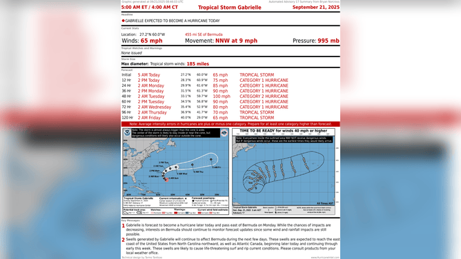
This graphic shows information on Tropical Storm Gabrielle on Sept. 21, 2025.
(FOX Weather)
The National Hurricane Center is forecasting Gabrielle to be close to Category 2 strength when it’s about 200 miles east of Bermuda late tomorrow.
On average, four hurricanes have formed by this date, so this hurricane season is officially behind schedule. Remember that half the seasons between 1991 and 2020 had to have fewer hurricanes that balance the busy seasons to create the averages. We just haven’t experienced a relatively quiet season lately. Although we obviously still have October to go.
In the tropical Atlantic
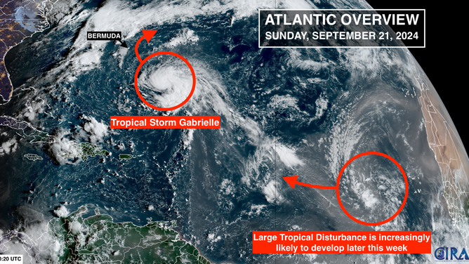
This satellite image shows Tropical Storm Gabrielle and a tropical wave in the Atlantic on Sept. 21, 2025.
(FOX Weather)
The National Hurricane Center has increased the development odds on the large disturbance in the tropical Atlantic. The system is embedded in dry and dusty air, but by later this week, it looks to be in a more conducive environment to development. The odds are now set in the medium range.
Current forecasts show that this system will not be a significant threat to land, but we’ll have to watch it for the northeastern Caribbean islands to be sure. In any case, it could bring at least a gusty moisture surge to the islands around midweek.
The long-range forecast
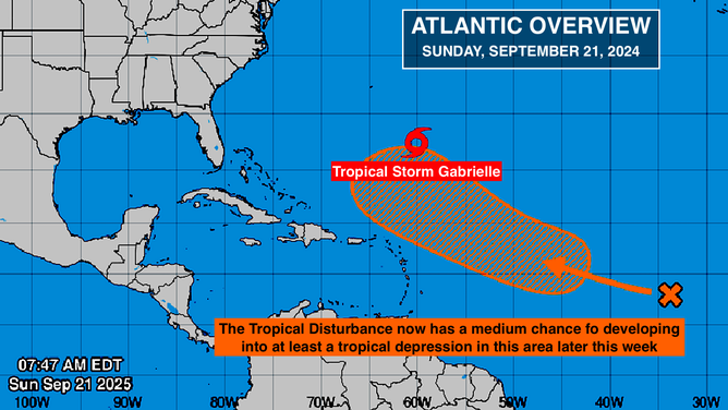
This graphic provides an overview of the tropical Atlantic Basin on Sept. 21, 2025.
(FOX Weather)
There’s potential good news in the long-range forecasts from the computer forecast models. They are all showing a sharp dip in the jet stream developing over the southeastern U.S. – similar to the persistent feature that has kept tropical systems well offshore so far this season.
Last week, it looked like there was a possibility that the disturbance the NHC is following and/or a second-week disturbance might turn into a threat. Some of the computer forecasts still show one or both of the systems developing into tropical storms or hurricanes, but if the jet stream dip materializes as forecast, the eventual path north should be offshore of the U.S.
That’s not 100% yet, but the trends are good. And it means, of course, Bermuda will have to watch these systems next week.
Forecasts for individual disorganized tropical disturbances more than a week in advance are always low confidence. But when multiple computer forecast systems all predict a large and dramatic dip in the jet stream, we take that forecast as being somewhat less uncertain.
We also have to be aware that strong jet stream dips can scoop tropical systems out of the western Caribbean or southern Gulf and pull them north. There are hints of that in some of the long-range forecasts, but the odds at this point are in the very low range.
It all bears watching, of course, but if things work out something like the long-range predictions are showing, the storm track offshore the East Coast would continue into the first week of October.


