FOX Weather is your Hurricane HQ
(FOX Weather)
Updated at 9:45 a.m. ET on Monday, Sept. 22, 2025
Hurricane Gabrielle will make its closest approach to Bermuda later today. The center is forecast to track more than 150 miles offshore, but the storm will cause large, dangerous swells to impact the island. Winds are not expected to be dangerously strong.
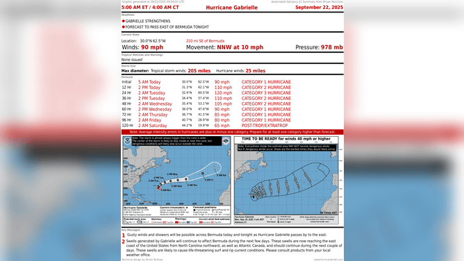
This graphic shows information on Hurricane Gabrielle.
(FOX Weather)
Some swells are reaching the U.S. East Coast. The ocean will begin to calm down tomorrow as Gabrielle accelerates into the open ocean. The Azores Islands off Portugal will have to keep an eye on it for later in the week.
Developing tropical disturbances
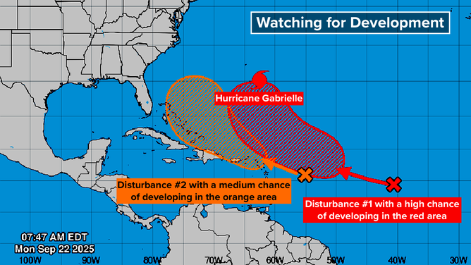
This graphic provides an overview of the tropical Atlantic Basin.
(FOX Weather)
The National Hurricane Center reintroduced a disturbance we were watching last week – the orange X on the map. I’m calling it Disturbance 2, just to keep them straight. This was the one we were concerned about because it was forecast to move farther west and perhaps turn north in a threatening way.
Orange means that the NHC is giving the system a medium chance of developing into a tropical depression over the next several days. There is no consensus in the various computer forecast models on what’s going to happen, but many options include the system organizing. The possibilities range from a significant threat to the Southeast to little if any development.
Disturbance 2 disappeared from the map late last week because the dry air obliterated its clouds and thunderstorms, and it was impossible to follow. The energy from the disturbance continued west, however.
Now, thunderstorms have redeveloped, and the computer forecast models are tracking the system once again.
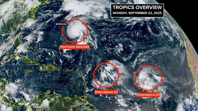
This satellite image shows Hurricane Gabrielle and two tropical disturbances that could develop over the next week.
(FOX Weather)
Another change since last week is that now there is a strong consensus that a sharp dip in the jet stream is going to plunge into the Southeast this week. The jet stream dip will tend to keep any storms that try to get near the U.S. East Coast offshore and push them off to the north … at least through this week.
About next weekend, things get murky, however. There is wide disagreement in the long-range forecasts on how the pattern will evolve, and where Disturbance 2 will be in several days.
Will it be pulled north, or will it be blocked? Will it develop? Or will it track close to Disturbance 1 and be weakened by the interaction? If it stays weak, it could track into the Caribbean and be pulled north from there.
That’s all nearly a week away. Obviously, a lot can change in that time. For now, we just have to watch and be aware that something annoying could develop with this system around the weekend.
The red X represents Disturbance 1, a large disturbance with a high chance of developing. For now, that system is embedded in dust and dry air.
As indicated by the large red potential development area, it’s not clear when it will pull itself free, but it’s likely to develop. Many forecasts show it becoming a strong hurricane that, more or less, follows Gabrielle in the general direction of Bermuda.
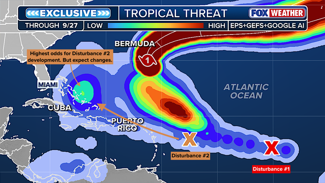
This graphic shows the tropical threats in the Atlantic.
(FOX Weather)
The exclusive Tropical Threat analysis looks for a consensus among the European, U.S. GFS and Google DeepMind AI models on where or if systems will develop into at least a tropical depression. You can see that there is high agreement that Disturbance 1 will head north following Gabrielle. For Disturbance 2, the consensus is in low to medium range that a system will develop near the Bahamas. But there is a lot of spread in the possible tracks.
The next two names on the list are Humberto and Imelda. Chances are we’ll use Humberto, and maybe both.


