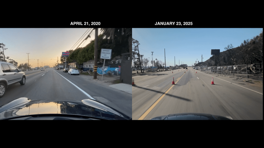
Nearly five years ago, in the early days of the COVID-19 pandemic, KTLA’s Andy Riesmeyer strapped a cellphone to the roof of his car and filmed a drive up Pacific Coast Highway.
It was a quiet, almost eerie moment in time, capturing an empty stretch of one of California’s most scenic roadways.
Now, in the wake of the devastating January wildfires that destroyed more than a century of California history, that footage serves as a reminder of what once was—and what could be again.
PCH has long been considered one of the greatest drives in the world, a rite of passage for Angelenos. The sun, the surf and the coastline are iconic.
But today, in the wake of the Palisades Fire, the landscape is vastly different.

Andy started recording in Topanga. On the left, the beach; to the right, the Reel Inn where you could look at pictures on the wall of fires the restaurant had survived over the years.
Then the Topanga Ranch Motel, built in 1929. Rosenthal Winery, Wiley’s Bait Shop, Cholada Thai.
Just past Tuna Canyon Road is where Los Angeles ends and Malibu begins, where homes stood for decades.
Now, home after home—gone.
Today, behind a concrete barrier, law enforcement, the National Guard, disaster cleanup companies and utility companies like SoCal Edison are working on the burned power poles.
-

Side-by-side images show Pacific Coast Highway before and after deadly fires devastated the Los Angeles region. Captured on April 21, 2020, and January 23, 2025. (Andy Riesmeyer) -

Side-by-side images show Pacific Coast Highway before and after deadly fires devastated the Los Angeles region. Captured on April 21, 2020, and January 23, 2025. (Andy Riesmeyer)
Continuing past Big Rock Drive, rows and rows of low-slung beach houses are reduced to charred bricks, debris and cars. At the end of a stretch of homes, the place where Moonshadows, a cherished Malibu landmark, once stood.
Somehow, miraculously, you’ll see a block of seemingly untouched homes across the roadway from a rock a concrete wall. Beyond that cement break, the destruction resumes.
By the time you get to the iconic Duke’s Restaurant, much of the devastation eases because the fire was held at Las Flores.
Traveling south on PCH, it’s more of the same, miles and miles of destruction against the Pacific Ocean.
“I noticed in the distance the skyline and realized it’s the first time downtown Santa Monica has been visible from this part of the highway in generations.”
It’s still unclear how long it will be before people can get back and start to rebuild their homes and their lives and the devastation in Southern California reaches far beyond Malibu.
For ways you can help, visit ktla.com/LAstrong.


