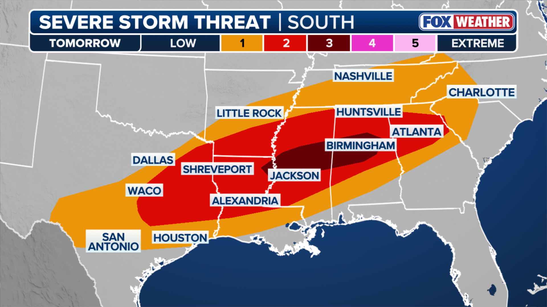
Severe storms are expected to ramp up this afternoon, with a Level 2 out of 5 risk spanning portions of Texas to Missouri, where large hail, damaging winds, and tornadoes will all be possible. This is all part of a multi-day threat as a cold front sweeps across the nation. FOX Weather Meteorologists Stephen Morgan and Marissa Torres break down what to expect:
The first week of May is off to an active start as a sprawling cold front marches across the country, bringing renewed severe storm threats. While this system may not be as intense as the outbreaks seen at the end of April, impacts are still expected—especially across the South.
Large hail, damaging winds and tornadoes will all be possible with any storms that develop.
(FOX Weather)
The storms kicked off Monday with severe threats expanding from North Texas into the Midwest, where local news outlets reported damaging winds in Detroit.
These initial bursts are just one part of a multi-day severe weather threat expected through midweek, alongside the broader impacts of a massive cold front sweeping the nation.

FILE: Large, dark storm clouds seen near Snyder, Texas on Oct. 3, 2023.
(@AnnHd04 / WEATHER TRAKER /TMX / FOX Weather)
WINTER STORM WARNING ISSUED FOR DENVER AS COLORADO, WYOMING BRACE FOR SIGNIFICANT MAY SNOWSTORM
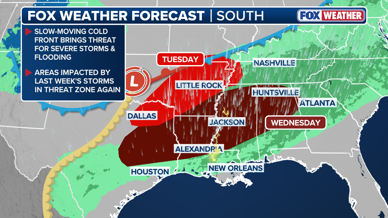
The severe threat shifts further south Tuesday, where a Level 2 out of 5 risk is in effect for portions of the region, stretching from the northeast part of Texas up into the southern portion of Missouri.
Into the afternoon, the potential for severe weather across the South increases as the cold front keeps sinking southward.

(FOX Weather)
Meanwhile, a separate area of low pressure along the front is expected to help spark thunderstorm development across parts of Oklahoma, Arkansas, and the Ark-La-Tex region by the evening, aided by rich Gulf moisture and a strengthening low-level jet.
EXPERTS CONFIRM THIS HAILSTONE BROKE THE RECORD AS THE BIGGEST IN TEXAS HISTORY
By Wednesday, the Level 2 out of 5 severe weather threat pushes even farther south, impacting portions of Texas, Louisiana, Arkansas, Mississippi, and Alabama, where large hail, damaging winds, and tornadoes will all be possible with any storms that develop.

FILE: A tornado moves along the ground near Cabool, Missouri, on May 26, 2024.
(Brett Adair/LSM / FOX Weather)
The cold front will start to slow down as it bumps into a high-pressure system parked off the East Coast.
(FOX Weather)
Wednesday is shaping up to have the most significant chance to spark more discrete storms later in the day, and if the storms can stay discrete, there will be a greater tornado threat, the FOX Forecast Center said.

FILE: A shelf cloud seen ahead of severe thunderstorms in Sheffield, Alabama on Aug. 7, 2023. (Image: @TN_Valleywx/Twitter)
(FOX Weather)
However, if the storms stay as segments or a line of storms, then the threat will be primarily damaging winds and large hail.
Additionally, this setup is expected to bring several days of rain too, with the heaviest downpours expected Wednesday in the South due to the slow movement of the front and the potential for training storms over the same areas.

(FOX Weather)
A large Level 2 out of 4 flash flood risk is in place for a large portion of the Southeast. The rain will continue beyond Wednesday, where rain totals will generally mount up to 2 to 3 inches over a wide area.

(FOX Weather)
Along with the severe weather and flash flood risks, the massive cold front sweeping the nation is also packing a broader punch.
TRIPLE THREAT: MASSIVE COLD FRONT TO UNLEASH SNOW, SEVERE STORMS AND HEAVY RAIN ACROSS 25+ STATES
While it’s fueling severe storms across the South, it’s also bringing threats of flooding rain to the Midwest and Northeast, and an impactful snowstorm across the central Rocky Mountains.
Stick with FOX Weather for the latest updates as the storms develop.


