Much of the Houston area is under a level 2 flood threat, so we’ve issued a Weather Impact Alert.
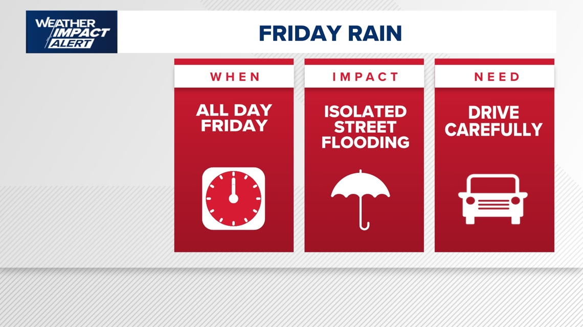
HOUSTON — A Flood Watch is in effect across Southeast Texas through Friday night as a slow-moving system brings widespread heavy rain to the Houston area. According to KHOU 11 Chief Meteorologist David Paul, this setup is driven by an upper-level disturbance and a frontal boundary already pushing into the region. The combination will create a prolonged period of rainfall beginning in the early morning hours and lasting through the evening, with the greatest concern centered on street flooding and hazardous travel conditions.
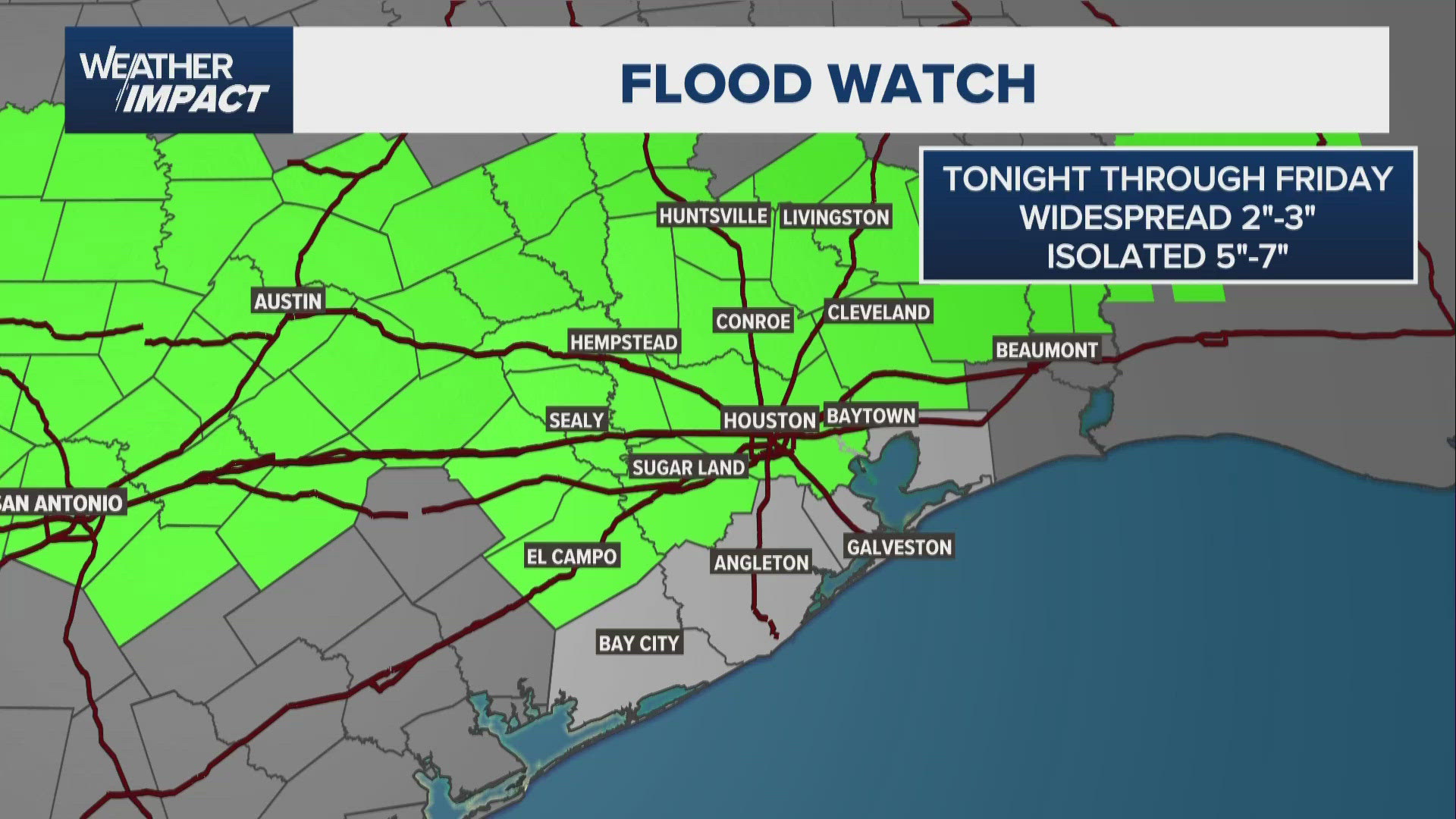

A Flood Watch is in effect from 3 a.m. Friday through late Friday night across much of Southeast Texas, including Houston, The Woodlands, Sugar Land, Conroe, and College Station. The National Weather Service says excessive rainfall could lead to flooding, especially as multiple rounds of storms move through the region.
Widespread impacts are possible, with low-lying and flood-prone areas at the highest risk. This includes neighborhoods near bayous, creeks, and poor-drainage streets across Harris, Fort Bend, Montgomery, and surrounding counties.
A Flood Advisory is in effect until 8 a.m. Friday for parts of the Houston area, including Harris, Fort Bend, Montgomery, and Waller counties. The National Weather Service says minor flooding is already happening or about to begin due to heavy rain moving through early this morning.
Radar shows 1 to 2 inches of rain has already fallen, with another 1 to 2 inches possible, increasing the risk of street flooding and water-covered roads during the morning commute.
Rain is expected to begin ramping up before sunrise, with the first organized round arriving between 3 and 4 a.m. By the start of the morning commute, conditions are expected to deteriorate quickly, with heavy rain becoming widespread across much of the Houston area. This could significantly impact travel, with high water spots developing on roads and freeways as rainfall intensifies during peak commute hours.
The pattern throughout the day suggests multiple waves of energy moving across Southeast Texas, keeping rain chances high from morning through late afternoon. While there may be occasional brief breaks in the rain during mid-morning, additional rounds are expected to redevelop by midday and continue into the afternoon. At times, rainfall could be heavy enough to overwhelm drainage systems, especially in low-lying and flood-prone areas that typically collect water during heavy downpours.
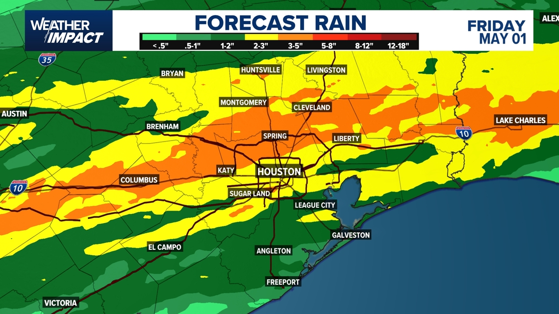
Rainfall totals are expected to be significant. Widespread areas could receive 2 to 3 inches of rain, with isolated locations picking up as much as 5 to 7 inches. The heaviest totals are expected north and west of Houston, including areas along the Spring Creek, Cypress Creek and Greens Bayou watersheds. While bayous are currently low and expected to handle most of the runoff, officials will be monitoring conditions closely given the volume of rain expected in a relatively short period of time.
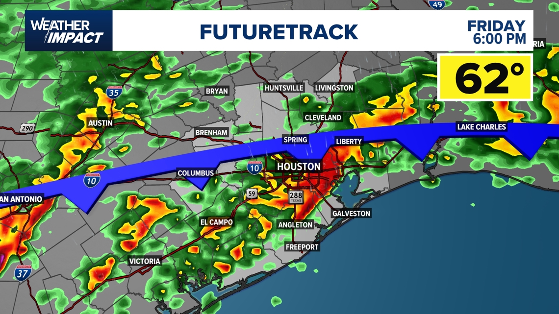
By late afternoon and into the evening, a push of drier air behind the front will begin to move the rain out of the area. Conditions are expected to gradually improve after sunset, with rain ending between 9 and 10 p.m. This will usher in a cooler and drier air mass heading into the weekend, bringing a noticeable change after what is expected to be a messy and potentially disruptive Friday across the Houston area.
Hour-by-hour breakdown for Friday
First round of widespread rain develops
Heaviest activity begins west and north of Houston
Heavy rain expanding across the region
Morning commute becomes difficult
Widespread rain described as a “rainy mess”
High water spots developing on roadways
Possible brief breaks in some areas
Flooding risk remains due to earlier rainfall
Another round of rain moves in
Conditions worsen again around lunchtime
Persistent rain continues
Periods of heavier downpours likely
Street flooding possible to widespread at times
Front begins pushing toward the coast
Rain gradually shifts south toward the coast
Cooler, drier air moves in
Day-by-day forecast
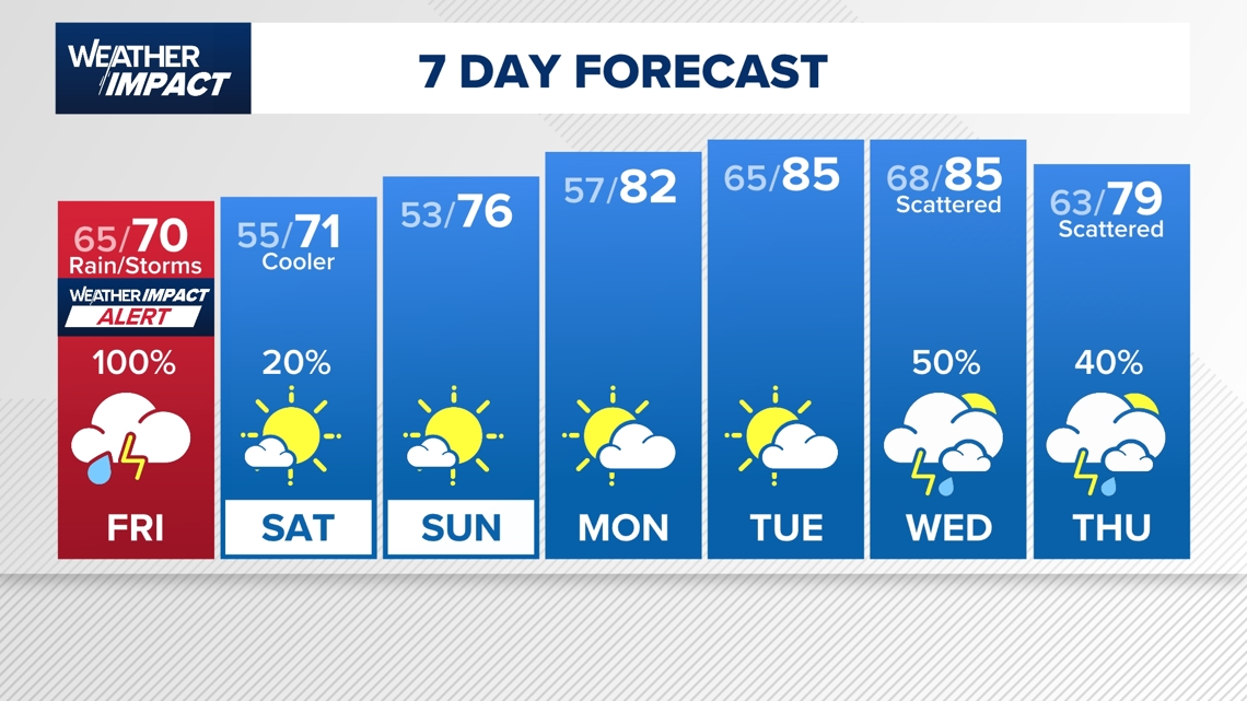
100% chance of rain at times
Widespread 2 to 3 inches of rain, isolated 5 to 7 inches
Street flooding likely in low-lying areas
Cooler, dry with sunshine returning later in the day
Continued cool and dry conditions
Low around 57, high near 82
Return of a more active pattern
Increasing chances for scattered showers and thunderstorms
Continued rain chances as a wetter spring pattern sets up across Texas and the southern United States
Counties we serve:
Harris County (including Houston, Pasadena, Baytown), Fort Bend County (Richmond, Sugar Land, Missouri City), Montgomery County (Conroe, The Woodlands), Brazoria County (Angleton, Pearland, Alvin, Lake Jackson), Galveston County (Galveston, League City, Texas City), Liberty County (Liberty, Cleveland, Dayton), Walker County (Huntsville, New Waverly), Waller County (Hempstead, Prairie View, Waller), Polk County (Livingston, Corrigan), Chambers County (Anahuac, Mont Belvieu, Winnie), Wharton County (Wharton, El Campo), Washington County (Brenham), Matagorda County (Bay City, Palacios), Grimes County (Anderson, Navasota), Austin County (Bellville, Sealy), Colorado County (Columbus, Eagle Lake, Weimar), Trinity County (Groveton, Trinity).


