FOX Weather Meteorologist Bayne Froney analyzes a marathon severe weather threat targeting millions from the Southern Plains into the upper Midwest on Friday.
After a memorable winter, spring has marched in with an active attitude. A multi-day severe weather outbreak is underway as intense storms target the Central U.S. on Friday, putting millions at risk across several major cities from the Plains to the Midwest.
A sweeping cold front ahead of a dryline will set the stage for 1,000 miles of severe storms to break out Friday evening into Saturday as the active period of severe weather eyes the Central U.S.
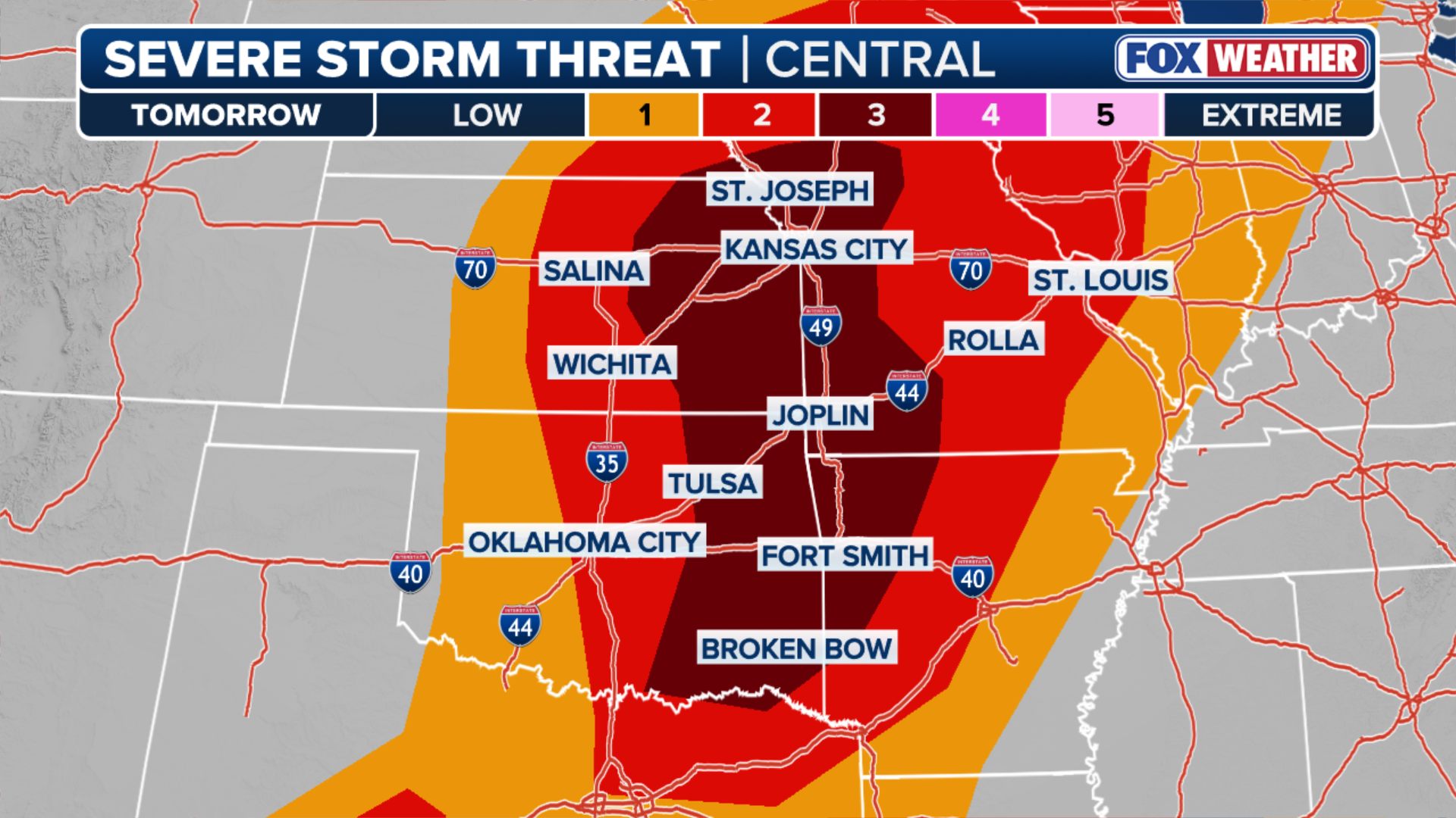
At the tail end of a three-day, severe weather bender, a Level 3 out of 5 severe storm threat is in place in parts of Oklahoma, Texas, Missouri, Arkansas, Kansas and Nebraska.
A larger area under a lesser severe storm threat extends from the Southern Plains into the Midwest, setting the stage for a significant and sizable severe weather event.
(FOX Weather)
A parade of storms kicked off the mid-week severe weather event on Wednesday, and on Thursday, an upper-level trough swung into the Southern Plains, interacting with warm, moist air, spawning severe storms.
Though formidable storms swept across the region on Wednesday and Thursday, NOAA‘s Storm Prediction Center (SPC) highlighted Friday as having the greatest risk of large hail, damaging wind gusts and tornadoes.
WHAT IS A DRYLINE AND WHY IS ITS LOCATION IMPORTANT IN SEVERE WEATHER FORECASTING?
A dryline is forecast to set up further to the East as a cold front slides across the Central U.S., interacting with Gulf air that will serve as a detonator for 1,000 miles of severe storms to erupt from South Texas into the upper Midwest.

On Friday, storms will develop along and ahead of a dryline as it shifts East. As the cold front shifts East Friday night 1,000 miles of severe storms could develop across the Southern Plains and into the Midwest.
(FOX Weather)
Low-level winds, approximately 5,000 feet above the surface, are expected to intensify both to the north near Kansas City and to the south toward Oklahoma City and Dallas, a key ingredient that will provide more lift and give way to more intense storms.
SPRING FORWARD 2026: EVERYTHING YOU NEED TO KNOW AS DAYLIGHT SAVING TIME BEGINS SUNDAY
As the dryline gives way to moist Gulf air, combined with strengthening low-level winds, the potential for a severe storm outbreak increases significantly.
(FOX Weather)
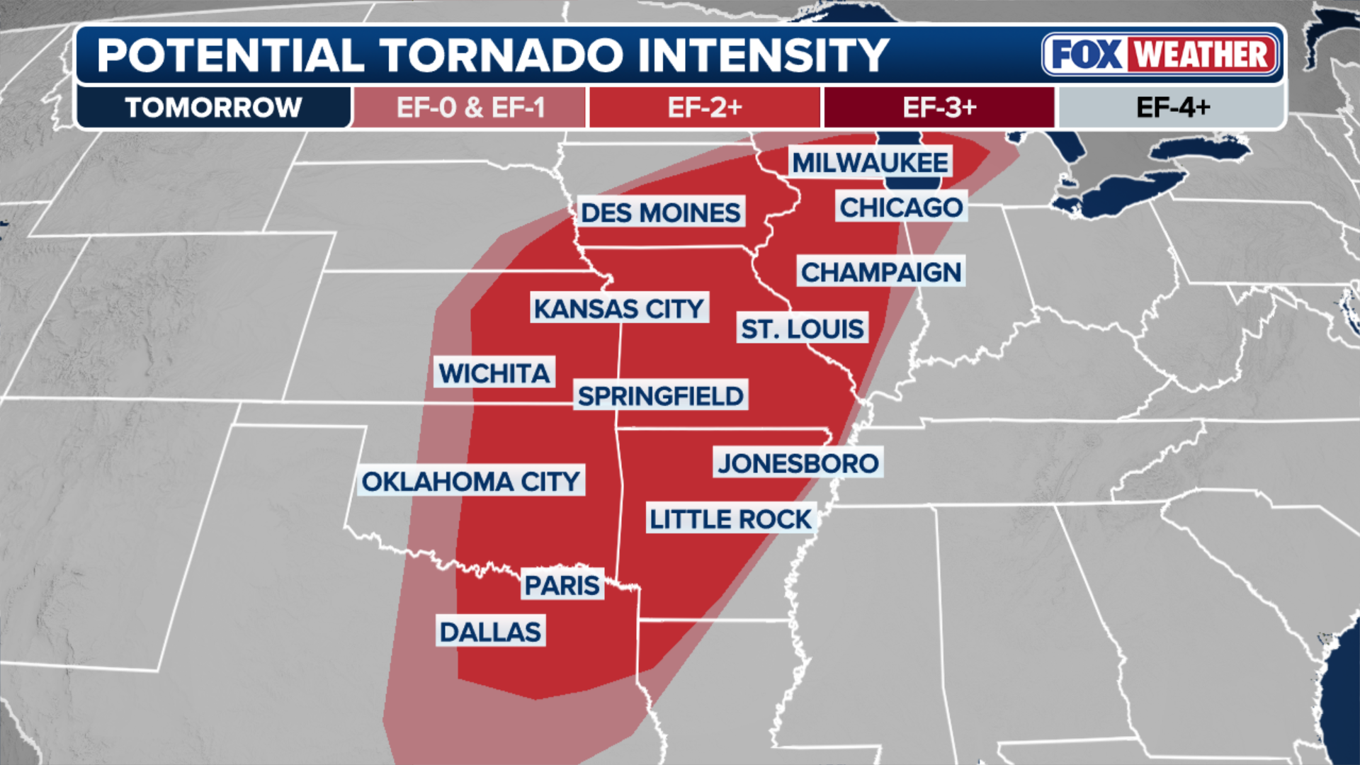
According to the FOX Forecast Center, a more favorable area of wind shear will develop, creating an environment ripe for supercells and an increased tornado threat.
WHAT IS A SUPERCELL THUNDERSTORM?
Strong tornadoes are possible from Kansas City to Wichita to Oklahoma City during the early evening hours Friday when the best atmospheric conditions will be in place.
(FOX Weather)
On top of the pressing tornado threat, all other severe hazards are likely to emerge by midday Friday, continuing through the overnight hours and into early Saturday morning.
NOAA’S STORM PREDICTION CENTER DEBUTS REVAMP TO SEVERE WEATHER OUTLOOKS THIS SEASON
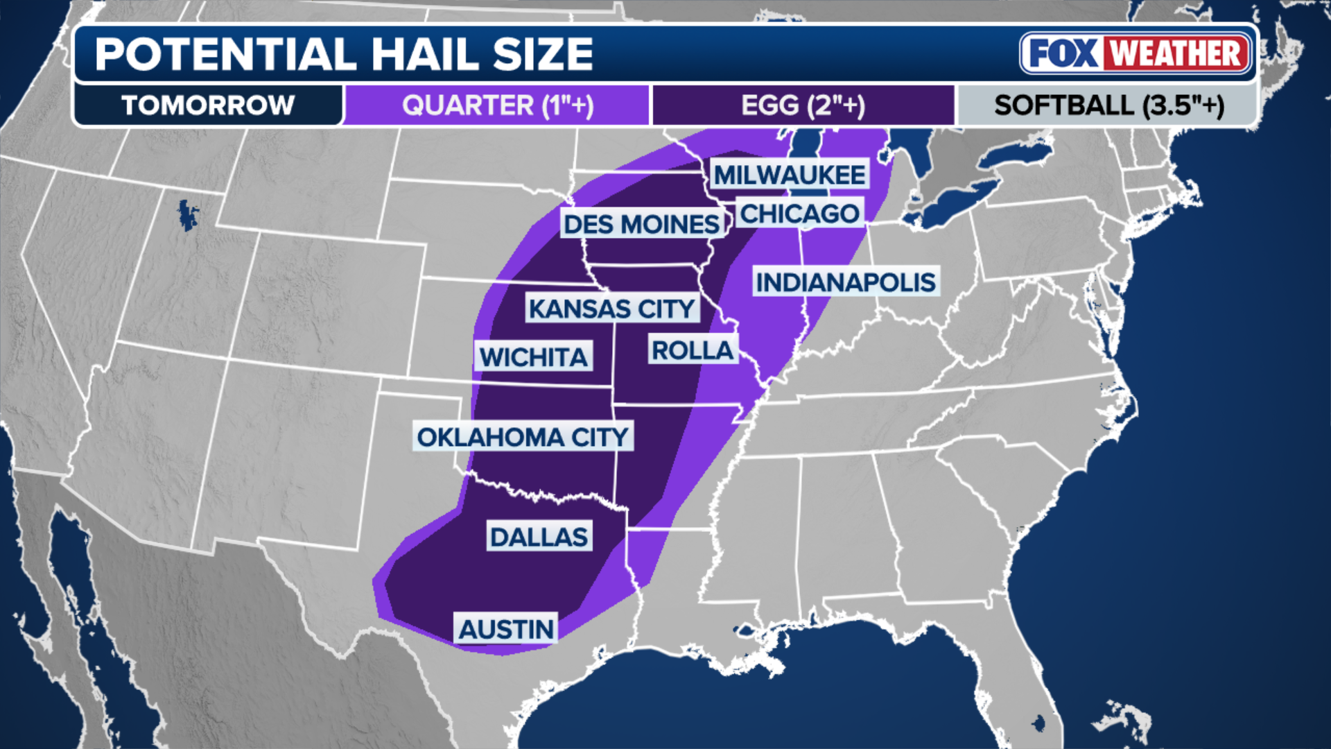
Very large to monster-sized hail, greater than 3″ in diameter, is a major concern, particularly on the northern side of the storm system.


