The FOX Forecast Center is monitoring three rounds of winter weather that will impact 25 states across the Midwest and Northeast through the middle of next week. The first will be a stripe of snow across the Midwest on Saturday which will lead into light Northeast snow Sunday morning. The second wave will primarily be Sunday through Monday starting in the Midwest and impacting the I-95 corridor in the Mid-Atlantic on Monday. The final wave will primarily be Tuesday into Wednesday with a focus on the Northeast and Mid-Atlantic. Even in the higher-end scenarios these storms will not be as impactful as the historic blizzard earlier this week.
Millions of people across 25 states in the winter-weary Midwest and Northeast face three different winter storms that are set to bring more snow and dangerous ice starting this weekend. The weather setup of each storm is different, reflecting an ongoing battle between lingering cold air digging south from Canada and warmer air from the Gulf being pulled north, as the calendar flips to March.
Due to these complex atmospheric dynamics, exactly how much snow and ice will fall and where still remain something of an open question. But even at the highest end projections, these storms will not be as impactful as the historic blizzard that slammed the Interstate 95 corridor earlier this week.
(FOX Weather)
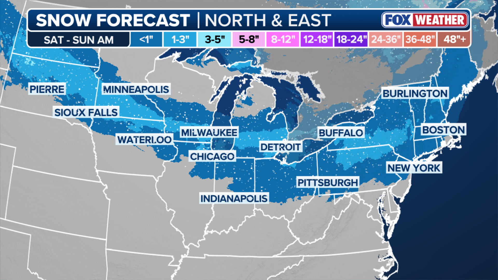
First winter storm to bring stripe of snow along northern tier
According to the FOX Forecast Center, snow will break out along the leading edge of cold air early Saturday across Montana and the Dakotas, before spreading to the Upper Midwest and Great Lakes by Saturday evening.
HURRICANE MELISSA TIES RECORD FOR STRONGEST HURRICANE IN ATLANTIC HISTORY
Accumulation from this fast-moving system should be limited to less than 3 inches.
The cold air and snow will then reach the interior Northeast early Sunday morning, with the most snow expected in cities like Pittsburgh, Pennsylvania, Albany, New York and Manchester, New Hampshire.
(FOX Weather)
Snow will also reach New York City, Providence, and Boston Sunday morning but accumulations are expected to be an inch or less.
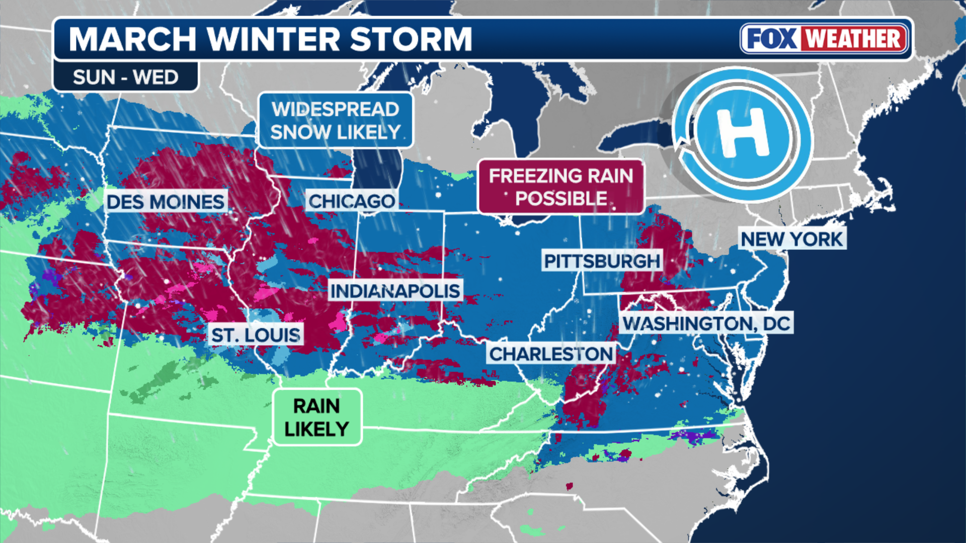
Second storm to pack stronger punch and brings ice threat for Midwest, Ohio Valley
Just as the first wave ends in the Northeast, a second storm will develop along the tail end of the passing cold front on Sunday night.
Warmer, moist air from the Gulf will be pulled north by strengthening southerly winds and ride up over the front — a phenomenon meteorologists call “overrunning.”
Computer forecasts have not quite pinned down exactly where the snow-rain line will set up, which will play a big role in which regions see dangerous road conditions caused by freezing rain and ice within that transition zone.
Based on current data, the greatest icing concern is centered along the Interstate 70 corridor and through the Ohio River Valley.

(FOX Weather)
Currently, higher-end computer forecast scenarios show a 3–5 inch swath of snow for Chicago, Detroit, Pittsburgh, Philadelphia, and potentially New York through Monday. Meanwhile, lower-end scenarios call for 1–3 inches of snow across the same region, with a heavier mix of ice and rain.
Third winter storm could bring a parting shot of snow, ice to Northeast
The third is expected to arrive on Tuesday, as warm air from the south gets caught between the Arctic area of high pressure exiting off the Eastern Seaboard and a developing low-pressure system in the Plains.

(FOX Weather)
This storm is expected to deliver mostly beneficial, snow-melting rain.
However, the air should remain just cold enough across some parts of the Northeast for ice and snow.
“The best chance for accumulating snow will remain north of Interstate 90, while significant icing will be a concern across Pennsylvania, where below-freezing air will stay trapped in the valleys,” the FOX Forecast Center said Friday.


