It seems there is no end in sight for the severe weather that sent more than four tornadoes spinning across the United States this week.
Friday morning, Mississippi locals were given just minutes to take cover as severe thunderstorms created a terrifying tornado threat.
‘TAKE COVER NOW! Move to a basement or an interior room on the lowest floor of a sturdy building,’ an alert issued by the National Weather Service rang out in Jackson Thursday morning.
‘Avoid windows. If you are outdoors, in a mobile home, or in a vehicle, move to the closest substantial shelter and protect yourself from flying debris.’
The sudden warning was issued just before 9am, with potential cyclones spinning through the state as soon as 9.05am. Winds gusts kicked up to 80mph, and hail was spit out as the storm brewed.
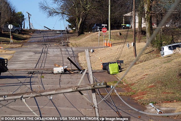
At least four tornadoes were also spotted in Oklahoma and Kansas this week, leading to roof damage, power outages and toppled utility poles.
It seems strong winds, looming thunderstorms and tornado threats will be a theme for the weekend as more severe weather grips the country.
Lower Mississippi, Louisiana, Georgia and Alabama are set to be hit with more severe thunderstorms as the weekend continues, according to The Weather Channel.
Severe weather this week brought tornado warnings to the Southern US, with conditions expected to continue over the weekend. Pictured are broken powerlines in Purcell, Oklahoma

The Midwest and Northeast US could see some snowfall along with high winds

Oklahoma and Kansas were rocked by multiple tornadoes this week

High wind gusts will rock much of the Eastern US as looming thunderstorms and snowfall threaten the region

Resident Richard Hill shovels the sidewalk outside his home in Vergennes, Vermont this week
Saturday morning could mean more tornadoes for Coushatta, Louisiana and Carson, Mississippi, with two possible cyclones brewing, causing damage already on Friday night.
Isolated severe thunderstorms will extend to the eastern US and into the Carolinas, churning up a tornado threat.
The Great Lakes, Midwest and New England may see light to moderate snowfall, but without majorly cold temperatures, heavy snow is unlikely.
Rain coupled with wind gusts up to 50 mph may lead to dangerous driving conditions.
The deep south will continue to be afflicted by heavy rain and flash flooding.
Mississippi and Alabama are predicted to accrue more than five inches of rainfall.
Severe thunderstorms with the proper ingredients for tornadoes could roll over the eastern US on Saturday afternoon.
Strong wind gusts are expected to move east across the country from Saturday and into Sunday.

While some snowfall is expected, meteorologists do not predict bitterly cold tempuratures

Precipitation in the Eastern US could lead to five inches of accumulation in some southern states

Even without a tornado present, high wind gusts can be dangerous
As severe weather begins to die down on Sunday, the Midwestern and Eastern US should only have continued strong winds to worry about.
Rain may continue on Sunday on the East Coast, but snow showers make a pleasantly wintery appearance in the Great Lakes, Appalachia and New England.
Fortunately, the mixed bag of weather will not be met with bitterly cold temperatures.
The National Weather Service reported highs in the 70s in the Southern US, while the Northeast is not likely to dip below the 30s and 40s.
The Midwest is projected to see weather in the 40s and 50s over the weekend.
With more tornado warnings in sight, Americans in vulnerable areas should continue to monitor local weather alerts, per the Red Cross.
Gathering food, water, medicine and other emergency supplies could be crucial in preparing for severe weather.
Even without a cyclone present, high wind gusts can still cause power outages, damage homes and send debris flying.


