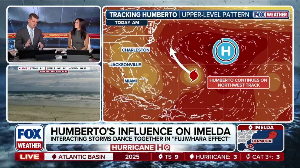
Tropical Storm Imelda is not going to make landfall in the southeastern U.S. as some early models indicated, and its sharp right turn out into the Atlantic is thanks to big influences by the much more powerful Hurricane Humberto.
Humberto topped out with 160-mph winds over the weekend as a Category 5 hurricane. The current track of Imelda is following a very similar northeasterly path.
According to the FOX Forecast Center, multiple weather features are influencing Imelda, which is good news for the U.S. Humberto to the east and a strong dip in the jet stream plunging into the North Atlantic are steering Imelda completely away from the U.S.
“A storm of that magnitude really does make a significant dent in the steering flow,” FOX Weather Meteorologist Stephen Morgan said of Humberto.
LIVE IMELDA TRACKER: SPAGHETTI PLOTS, FORECAST CONES FOR TROPICAL STORM IMELDA
By Tuesday morning, Imelda is expected to take a hard right turn, gaining momentum as it heads out into the Atlantic Ocean by Wednesday.
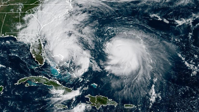
Tropical Storm Imelda on the left near Florida, and Hurricane Humberto on the right in the Atlantic, both seen by NOAA GOES Satellite on Sept. 29, 2025.
(NOAA)
FOX Weather Meteorologist Marissa Torres said Humberto’s influence was one reason why it’s important to look at multiple models for a tropical system.
“That’s what made the forecast for Imelda so complex. Anytime you’re forecasting a tropical cyclone, you have multiple variables. This was even more complicated because you had a developed hurricane that was also going to be influencing it,” Torres said. “To see the evolution of this forecast and the various models, you can learn a lot by not hanging on to just one run of one model. I think this is Humberto is kind of acting as the big brother, bringing along the young brother, saying, ‘Let’s go this way.'”
With two systems developing so close in the Atlantic, there has been a lot of mention of the Fujiwhara Effect. Meteorologists use the term when two tropical cyclones get close enough to each other to create a shared center, forcing the two storms to whip around that common central point.
However, Morgan says these two storms will likely not meet this standard.
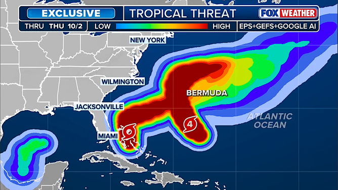
This graphic shows areas where tropical threats are highest in the Atlantic.
(FOX Weather)
“We have these two systems, which by all accounts have created a very jam-packed, a clogged western Atlantic. But as quickly as they clog, they’re going to escape fast and be helped out by the steering patterns and flow,” Morgan said. “But these two systems, just crisscrossing, interacting, having an influence on one another. I don’t think we can technically call this a Fujiwhara, but without a doubt, there is an influence. The proximity of these, if they were a little closer, we would maybe see that Fujiwara, but it’s really just Imelda finding the escape route.”
Both of these storms have Bermuda on alert with a one-two punch this week.
Humberto is forecast to pass north of Bermuda beginning Tuesday, creating tropical storm conditions. Imelda is then forecast to pass Bermuda later Wednesday and into Thursday, dropping another 2-4 inches of rain.
While the U.S. has dodged a landfall with Imelda, it is forecast to create indirect dangerous coastal conditions this week from Florida to North Carolina, including heavy rain, strong winds, massive waves, coastal flooding and dangerous rip currents.


