Updated on Sept. 27, 2025 at 10 a.m.: ;
The National Hurricane Center has designated the disturbance we’ve been following as Potential Tropical Cyclone Nine. The name just means that tropical storm watches and warnings have been issued for land areas based on the forecast of the system organizing and intensifying.
In this case, The Bahamas Department of Meteorology has posted Tropical Storm Warnings for the Central and Northwestern Bahamas, including Nassau, the Abacos and Grand Bahama Island. This is in anticipation of the disturbance becoming Tropical Storm Imelda while it’s in the vicinity of the islands later today and tomorrow.
There is high confidence that Imelda will move north offshore of the Florida east coast. The Miami/Fort Lauderdale/West Palm Beach metropolitan area could see some edge effects tomorrow into Monday in the form of gusty squalls and periods of heavy rain. The weather could be disruptive, but no direct hit from a significant storm is in the cards for South Florida. Boating conditions will, of course, be dangerous.
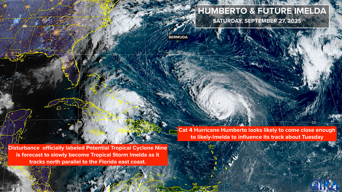
Potential Tropical Cyclone Nine and Hurricane Humberto remain active in Atlantic.
(NOAA)
Through Sunday and Monday, Imelda is forecast to intensify, reaching hurricane strength offshore of the Central or North Florida coast and head in the direction of the South Carolina coast.
Multiple weather features, including powerful Hurricane Humberto to the east, a non-tropical low-pressure system over the Southeast U.S. to the northwest, and a strong dip in the jet stream plunging into the North Atlantic mid to late week will all be vying to steer or grab Imelda.
There appear to be three scenarios in play: 1) the low pressure system over the Southeast pulls Imelda inland as a Category 1 or 2 hurricane; 2) Imelda moves slowly enough that it can be grabbed by the big dip in the jet stream that will also grab Humberto and move it out to sea; or 3) the various forces trying to affect Imelda’s track more or less neutralize each other, and the storm stalls over or near the Southeast coast.
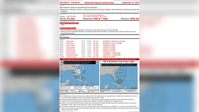
Potential Tropical Cyclone Nine
(Bryan Norcross / NOAA)
The National Hurricane Center’s official forecast takes the compromise position that Hurricane Imelda will stall near the coast or perhaps loop next Tuesday and Wednesday. Even if that happens, however, the storm could still impact land somewhere north on the East Coast late next week – after the time period covered by the cone. Although the odds of that occurring are lower than the storm tracking out to sea based on what we know now.
Even if likely-Hurricane Imelda does not make landfall, potentially dangerous rainfall is likely over at least South Carolina and the eastern 2/3 of North Carolina, with the Low Country and southeastern North Carolina getting the most. But if it makes landfall, as a number of the computer forecasts still indicate, rainfall capable of producing flash flooding will occur over a larger area, including in the mountains.
The majority of the computer forecasts now call for Imelda to slowly turn out to sea before making landfall, but it’s not a slam dunk. Hopefully we’ll get more certainty once the system develops and the computer forecasting systems have something more tangible to latch onto.
For now, residents of coastal Georgia, South Carolina and North Carolina should be thinking about what they’ll do next week if a hurricane makes landfall or parks itself nearby. Flood-prone areas from storm surge or heavy rain could become dangerous.
Remember the rule: forecasts for just-developing, disorganized, or slow-moving systems are subject to large errors and likely to change. This disturbance checks every box.
The exclusive FOX Weather Tropical Threat analysis, which is based on the consensus of the European, U.S. GFS, and Google DeepMind AI models, shows the fork in the road. There are high odds of Imelda tracking north. Then the odds get lower on what happens next.
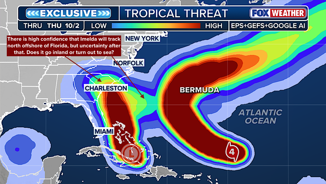
FOX Tropical Threat Model
(FOX Weather)
Hurricane Humberto
For the first time in the post-World War II record book, the first three hurricanes in the season have all reached Category 3 or stronger. Hurricane Humberto is already a Category 4 and is forecast to reach Category 5 strength tomorrow before slowly weakening as it heads north.
HURRICANE HUMBERTO NEARS CATEGORY 5 STRENGTH IN CENTRAL ATLANTIC
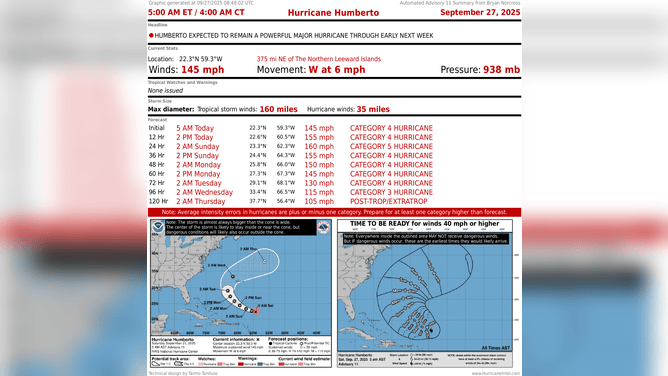
Hurricane Humberto
(Bryan Norcross / NOAA)
There is high confidence that Humberto will arc between the U.S. East Coast and Bermuda and then head out to sea. It will be a large storm when it passes Bermuda, however, so the island will likely have some impacts from the hurricane.
The exact track is not 100% certain, of course, and if it tracks to the left side of the cone, it’s more likely to affect the track of Imelda to its west, including causing it to stall and loop. This is one of the sources of the uncertainty in Imelda’s forecast.
Hurricane Humberto is forecast to be in the general vicinity of Bermuda Tuesday into Wednesday.


