FOX Weather is your Hurricane HQ
(FOX Weather)
Updated on Sept. 2, 2025 at 9:30 a.m. ET.
The tropical disturbance that came off Africa on Sunday is still very disorganized and shows no signs of a circulation developing yet. The consensus of the computer forecast models is that the atmospheric conditions ahead of it will be supportive enough that it can develop into a tropical depression or Tropical Storm Gabrielle.
The National Hurricane Center now has the odds in the high category of the system becoming at least a depression over the next week. NHC forecasters are drawing a large potential development area because it’s not clear when a bubble of atmosphere conducive to the system organizing will materialize.
TROPICAL DEPRESSION 7 NOW ‘LIKELY’ TO FORM SOON AS DISTURBANCE SLOWLY SWIRLS ACROSS ATLANTIC
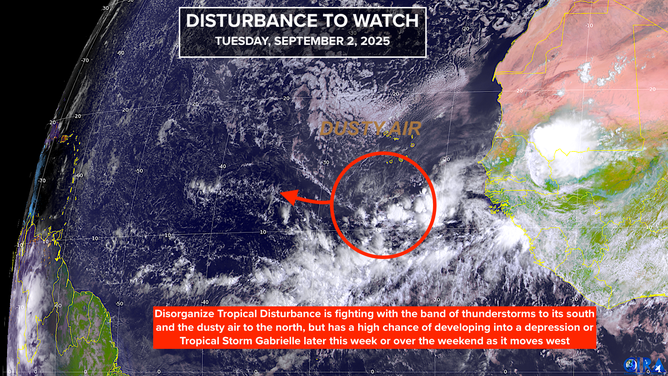
This is satellite imagery showing a disturbance off the coast of Africa.
(CIRA)
Currently, the disturbance is attached to the line of disturbed weather called the ITCZ – the Intertropical Convergence Zone – which is complicating its development. It’s also being pressed by Saharan dust from the north. Up ahead, it looks likely to encounter some hostile upper winds.
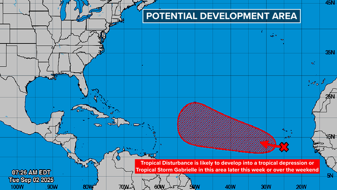
Assuming the system is able to organize, its strength is going to have a lot to do with its future track. The computer forecasts that organize and strengthen the system before it reaches the vicinity of the Caribbean islands show it turning quickly to the north into the open Atlantic. That’s the consensus of the long-range predictions at this point.
But we can’t discount the possibility of the system staying weaker longer and continuing on a more southern track closer to the islands.
If the system does organize and winds in the circulation reach at least 40 mph, it will be named Tropical Storm Gabrielle.
In any case, a series of strong jet stream dips are forecast to move off the U.S. East Coast, which should serve to lift the system north well east of the Bahamas.
There is low concern at the moment for potential Gabrielle to impact land, but we’ll watch to be sure it stays north of Puerto Rico and the northeastern Caribbean islands.
This graphic shows the tropics in the Atlantic Basin.
(Bryan Norcross / FOX Weather)
Elsewhere in the Atlantic
Besides potential Gabrielle, no other systems appear ready to develop. In another week or so, we’ll have to watch the persistent cold fronts that have been lodged over Florida, causing all the rain. They can become the focus for development over the Bahamas or off the Southeast coast, but there’s no sign of anything developing yet.
In the Pacific
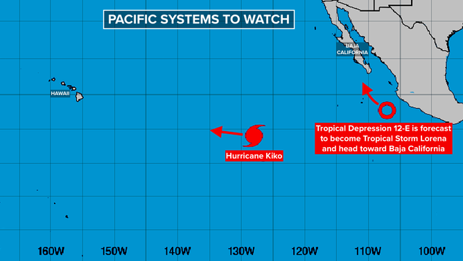
There are two systems of note. The tropical depression off the coast of Mexico is forecast to become Tropical Storm Lorena and track toward Baja California. The waters around Baja are relatively cool, so the system is expected to be weakening when it approaches land.
This graphic shows an overview of the tropics in the Pacific Basin.
(FOX Weather / FOX Weather)
The current forecast calls for Lorena to be a tropical storm at landfall, which can still have significant impacts, of course. Everyone in Cabo San Lucas and the surrounding area should stay informed of the latest forecasts.
Hurricane Kiko is heading in the general direction of Hawaii. The consensus of the long-range computer forecasts is that the storm will pass south of the islands, but it will bear watching.
The ocean water around Hawaii is relatively cool, compared to the very warm water Kiko is tracking over now. Long-range forecasts show the storm significantly weaker when it makes its closest approach to the islands around the middle of next week.
Residents of Hawaii, especially on the Big Island, should plan to stay informed.

