Bryan Norcross: The ocean will continue to be agitated along the East Coast Friday and Saturday – the National Weather Service is posting High Surf Advisories along the coast from North Carolina to the Canadian border. It will take a few days for the energy in the water to completely dissipate. Hurricane Erin was in the top 10% of biggest similar storms in the record book.
Updated at 10 a.m. EST on Aug. 22, 2025
Giant Hurricane Erin is moving away from land and its effect on the ocean along the East Coast is slowly diminishing. Miraculously, the storm will head out to sea having done little more than brush land areas.
The storm’s top winds are decreasing, and it’s accelerating away from land. Erin is forecast to become non-tropical tomorrow and turn into a massive North Atlantic storm. Gusty winds will brush Atlantic Canada as Erin goes by, and the system looks likely to bring bad weather to the UK or Northern Europe in a week or so.
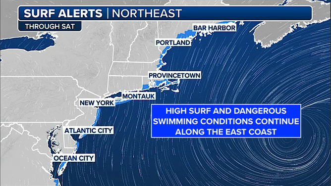
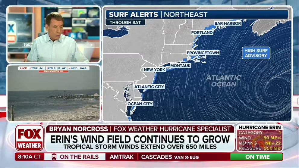
This graphic shows surf alerts through Saturday, August 23, 2025.
(FOX Weather / FOX Weather)
Hurricane Erin was in the top 10% of biggest similar storms in the record book. The slight turn it took on Wednesday afternoon pulled it just far enough from the coast to minimize the impacts in North Carolina, although the beaches were pounded by high waves along most of the East Coast.
The sea water levels were at moderate flood stage, with a few dipping into major flood, at a number of locations in the mid-Atlantic. I haven’t seen any reports of significant damage, however. We were very lucky.
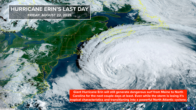
This graphic shows satellite imagery of Hurricane Erin.
(CIRA)
The ocean will continue to be agitated along the East Coast today and tomorrow – the National Weather Service is posting High Surf Advisories along the coast from North Carolina to the Canadian border. It will take a few days for the energy in the water to completely dissipate.
Local officials will evaluate whether the strong currents produced by the hurricane have diminished to a safe level for swimming. Inform yourself of the latest information before you go in the ocean.

While Erin spins away from the U.S., attention goes to a trio of tropical activity still in the Atlantic. FOX Weather Hurricane Specialist Bryan Norcross gives insight into the fates of Invests 99L and 90Land what we could see from the systems.
Elsewhere in the Tropics
The National Hurricane Center is still mentioning three systems, though none looks like a significant threat.
Near the Northeast Caribbean
The broad disorganized tropical disturbance that was tagged Invest #90L is passing northeast of the Caribbean. The system isn’t yet showing any signs of an organized circulation, but it will likely produce some gusty downpours as its moisture tail swings through the islands over the next few days.
The disturbance will track to the north and head in the general direction of Bermuda – well off the East Coast of the U.S. The National Hurricane Center has the system’s odds of developing into a tropical depression or tropical storm in the high range. Most computer models agree that it’s likely to become a tropical storm or possibly a hurricane as it moves north and then arcs out to sea.
Bermuda is going to have to keep an eye on this system. Most of the computer forecasts predict the storm will track to the east of the island, but forecasts for undeveloped systems are always subject to large errors.
The next name on the list is Fernand, but it’s not clear that this disturbance will be the first one to reach tropical storm strength.
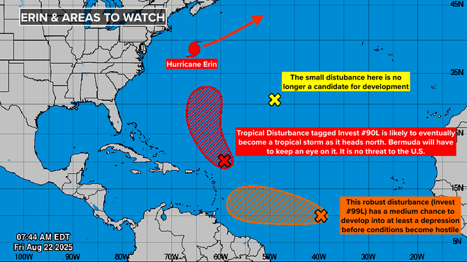
This graphic shows tropical activity in the Atlantic Basin.
(FOX Weather / FOX Weather)
In the Tropical Atlantic
A robust disturbance tagged Invest #99L has looked impressive on the satellite, but the system hasn’t had a well-defined circulation, which is the key criterion to being designated a tropical depression.
There’s still a chance that the system could spin up into a tropical depression or a tropical storm, but the window is fairly short. Hostile conditions are ahead. The National Hurricane Center’s odds for the system to become at least a depression are in the medium range.
That disturbance will likely move through the southern Caribbean islands as a moisture surge. We’ll have to watch it in nine or 10 days when it reaches the western Caribbean or the extreme southern Gulf – if it still exists at that time.
In the Central Atlantic
The National Hurricane Center was painting a small lemon where a non-tropical low-pressure system had a low chance of developing into a tropical depression. That possibility has evaporated.
Looking Ahead
Once these systems clear the board, nothing looks imminent. There’s a good chance we’ll finish August without another significant tropical system.
Remember, last year there was a long tropical snooze, and then the switch flipped in the middle of September. The point is, what happens now is not indicative of what is yet to come.
The broad pulse that moves around the Earth – called the MJO – that enhances or suppresses tropical activity is due to come back around after Labor Day. That doesn’t mean that something couldn’t develop in the meantime, but the odds are lower.


